
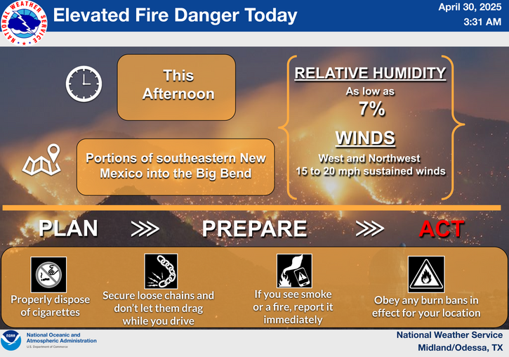
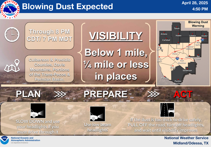
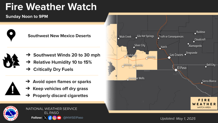
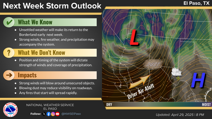
March 12th, 2019.
Malaga tornado west of US Hwy 285 courtesy of Nicole Simonton shared on FaceBook by Tina Kitchens.
Tornado Watch #17.

Tornado Watch #17 was issued for Southeastern New Mexico and parts of West Texas on Tuesday, March 12th, 2019 at 3:30 PM MDT by the Storm Prediction Center (SPC) and was in effect until 10 PM MDT that evening. This watch meant that conditions were favorable for the development of severe thunderstorm capable of producing tornadoes in and close to the watch area during this time frame.
Severe Thunderstorm Warning.

This GrLevel3 2.0 radar snapshot at 3:33 PM MDT showed the outline of the Tornado Watch (pink shaded box) as well as a Severe Thunderstorm Warning for Otero County which included the Alamogordo, Cloudcroft, and Mayhill areas. This rapidly developing squall line of severe thunderstorms was racing to the east at 55 mph.
Tornado Warning For South-Central Eddy County.

At 5:48 PM MDT a Tornado Warning remained in effect for south-central Eddy County including the Whites City, Black River Village, Loving, and Malaga areas. At 5:45 PM MDT a Park Ranger at the Carlsbad Caverns Visitors Center reported golf ball size hail covering the ground. Notice the strong hook echo showing up on radar wrapping back around into the Caverns Visitor Center. The main hail core was located east of Whites City along Creosote Rd and southward to the Black River. The severe thunderstorm producing the large hail and possible tornado was moving to the east at 50 mph.
GR2Analyst Radar Snapshot At 6:08 PM MDT..

Based on the Midland National Weather Service Survey Teams Assessment and radar data the Malaga tornado formed at 6:08 PM MDT southwest of the community. It lifted around 6:30 PM MDT or twenty two minutes later near State Highway 128 northeast of Malaga after being on the ground for 15 miles.
EF2 Tornado Near Malaga, New Mexico.
Another NWS survey team
investigated a tornado that
was spotted south of the
community of Malaga in Eddy
County New Mexico. A
special thank you to Stacy
Gifford for allowing us to use
this image for the survey
writeup.
Based on radar imagery, the tornado appeared to develop just west of U.S. Highway 285,
approximately 2-3 miles south of Malaga and progressed northeast, possibly for a number of
miles. The exact path could not be determined during the survey due to the tornado’s
containment within private lands, without roads to access the potential path. With insufficient
ground information, the wooden electric power poles along Highway 285 were the only
damage indicators available to assess tornado intensity.
Based on radar
information, it
appears the Malaga
tornado formed at
approximately 6:08
pm MDT, just
southwest of the
power poles on
Highway 285 and
lifted around 6:30
pm MDT (nearly
crossing NM
Highway 128, 3
miles east of
junction with NM
Highway 31)
covering a distance
of 15 miles.
Damaged power poles (image to the
right, provided by Malaga Volunteer Fire
Dept.) along Highway 285 were located
slightly further south than was indicated
on radar, 3.75 miles to 4.05 miles south
of Malaga. This was used as a starting
point. With the tornado crossing the
power poles at approximately a 45-
degree angle, the width of the tornado
was estimated at 1/5 mile.
Approximately 10 power poles that
were damaged to some degree as the
tornado crossed Highway 285. Poles on
the north and south limits were snapped
at 1/2 to 2/3 height from the ground, while near the center-line of the tornado's path, poles
were snapped close to ground level. The observed damage is consistent with damage of an EF2
tornado, with winds estimated at approximately 112 mph.
In addition to tornado and straight-line wind damage, there were several reports of large hail.
These reports included…
• 2.75-inch hail (baseball size) 6-7 miles north of
Pecos,
TX.
• 1.75-inch hail (golfball size) in Loving, NM and
at Carlsbad Caverns.
• 1.25-inch hail (half dollar size) in eastern Loving
County, TX.
• 1 inch hail was also reported in
various locations across
southeastern NM and West TX.
• Hail damage also occurred in
Malaga, NM although it is
unknown how large this hail
was at the time.


Malaga Tornado March 12th, 2019.
Malaga Tornado March 12th, 2019.
Courtesy Of Live Storm Chasers - Russ D. Contreras.
Malaga Tornado March 12th, 2019.
Malaga Tornado March 12th, 2019.
Courtesy Of Live Storm Media.
Scored a tornado today in Malaga, Nm.3.12.19
. pic.twitter.com/fTTlRGWgxl— Russ D.Contreras (@Stormtrek1) March 13, 2019
Location: Malaga , NM
— Live Storm Chasers (@Livestormchaser) March 13, 2019
Footage of a Tornado in Loving, NM
This is moving east at 30mph quickly along 128 through Eddy County.
Folks in the path of this storm need to take cover.
— Joseph Neubauer (@JNeubauerWx) March 13, 2019
Tornado - Malaga, NM
Video Permission: Angel Vargas#NMwx pic.twitter.com/1ZiBqBhPez
— Live Storm Chasers (@Livestormchaser) March 13, 2019
Exclusive | Close Range Tornado Video!Malaga, NM
Viewer/Follower Submitted
By: Natalie Gonzalez#NMwx #StormHour @StormHour pic.twitter.com/3p35HhqteF— Live Storm Chasers (@Livestormchaser) March 13, 2019
Tornadoes In Eddy County New Mexico.
Our last reported tornado in Eddy County prior to the Malaga tornado on March 12th, 2019 was an EF0 tornado that was reported 17 miles north-northeast of Carlsbad on September 17th, 2016 at 3:50 PM MST. It was estimated to be 200 yards wide and was on the ground for 0.92 miles. It touched down in open fields and no damages were reported.
Our last reported EF2 tornado occured in downtown Carlsbad on June 7th, 1992 at 8:10 PM MST. Six people were injured in this tornado. It was estimated to have been 73 yards wide and was on the ground for one half of a mile. The damage path was down Church street to the beach area then northeastward into La Huerta. Damages were estimated at $250,000.
See more of my blog posts on tornadoes in Southeastern New Mexico by going to my home page on my weather web page and clicking on the titles and links (Local Tornadoes) in the right hand sidebar.
The Truth Is Stranger Than Fiction - And Sometimes It Hurts!


No comments:
Post a Comment
Your comments, questions, and feedback on this post/web page are welcome.