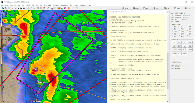
Dexter, NM Tornado March 12th, 2019.
GR2Analyst Radar Snapshot.
Captured At 6:03 PM MDT Tuesday, March 12th, 2019.
Public Information Statement
National Weather Service Albuquerque, NM
712 PM MDT Wed Mar 13 2019

...NWS DAMAGE SURVEY FOR 3/12/2019 TORNADO EVENT...

.OVERVIEW...
Just before 6 pm MDT on Tuesday, March 12th a tornado touched down in
Chaves county, about 15 miles south southeast of Dexter. The tornado
moved north northeast for approximately 15 minutes, and eventually
dissipated about one half mile northeast of the community of Dexter.
Six people suffered minor injuries, and six homes were substantially
damaged or completely destroyed. An additional dozen homes and
structures also sustained minor to moderate damage.

.DEXTER TORNADO...

RATING:                 EF-2
ESTIMATED PEAK WIND:    111 - 135 mph
PATH LENGTH /STATUTE/:  15 miles
PATH WIDTH /MAXIMUM/:   150 - 350 yards
FATALITIES:             0
INJURIES:               6

START DATE:             Mar 12 2019
START TIME:             0555 PM MDT
START LOCATION:         15 SSE Dexter / Chaves County / NM
START LAT/LON:          33.0010 / -104.4402

END DATE:               Mar 12 2019
END TIME:               0610 PM MDT
END LOCATION:           0.5 NE Dexter / Chaves County / NM
END_LAT/LON:            33.2104 / -104.3603

SURVEY_SUMMARY: A damage survey was completed today in Chaves county.
This was the first March tornado documented in Chaves county since
1959, and the earliest known EF1 or stronger tornado in the state of
New Mexico. The last EF2 tornado in New Mexico occurred on May 23,
2012.

EF Scale: The enhanced Fujita Scale classifies tornadoes into
the following categories.

EF0...Weak......65 TO 85 mph
EF1...Weak......86 TO 110 mph
EF2...Strong....111 TO 135 mph
EF3...Strong....136 TO 165 mph
EF4...Violent...166 TO 200 mph
EF5...Violent...>200 mph

NOTE:
The information in this statement is preliminary and subject to
change pending final review of the event and publication in
NWS Storm Data.
**TORNADO AFTERMATH** Heartbreaking scenes after a tornado moved through the town of Dexter, NM Tuesday evening. This video shows some of the damage from neighborhoods affected #nmwx @NWSAlbuquerque pic.twitter.com/hBZ9gRSAVk— Meredith Garofalo (@GarofaloWX) March 13, 2019
WOW... What a monster of a tornado!— Live Storm Chasers (@Livestormchaser) March 13, 2019
Near Hagerman, NM
Video Permission: Shani Pitzer#NMwx pic.twitter.com/DgtTJl8rrd
The Truth Is Stranger Than Fiction - And Sometimes It Hurts!


Comments
Post a Comment
Your comments, questions, and feedback on this post/web page are welcome.