Increasing Chances For T-Storms/Heavy Rainfall/Flash Flooding!


June 29, 2025.
West Of Hope, NM.

Blog Update at 12:23 PM MDT, Friday, July 11, 2025. 
Blog Updated at 1:12 PM MDT, Friday, July 11, 2025.

Parts of northeastern New Mexico have been upgraded to a Slight Risk for severe thunderstorms this afternoon and evening. Parts of southeastern New Mexico have been upgraded for a Slight Chance of severe thunderstorms on Saturday. 

Good News & Bad News!


Both good news and bad news or on the horizon, as we once again enter a pattern change with our weather here in New Mexico. The good news is that we will cool down, and scattered thunderstorms and rain showers become increasingly more likely today into next week. 

The bad news is that over the next week, the threat of locally heavy rains and flash flooding will also be on the uptick across most of the state this weekend into next week. Some of those areas of the state that have already flooded this year may do so again in the coming week. 

As has been the case since last year's fires, the burn scar areas will likely have the highest risk for flash flooding. This includes the Calf Canyon/Hermits Peak burn scars as well as the Ruidoso burn scars. Other burn scars and nearby areas in the state will also be susceptible to flash flooding. 

Scattered thunderstorms will also become capable of producing locally heavy downpours just about anywhere in the state this weekend into next week. The stronger of these storms will also be capable of producing localized flash flooding. 

A slow southward-moving cold front will backdoor down the eastern plains this afternoon into Saturday, adding additional lift, instability, and low-level upslope moisture to the state. Meanwhile, several upper-air disturbances will rotate around the ring of fire. Around the peripheral edge of the strong upper-level high-pressure ridge draped across the Desert Southwest, aiding in the production of the necessary lift and instability needed for thunderstorm production. A secondary cold front will work its way southward and backdoor down the eastern plains late next week as low-level Gulf of America moisture gets pulled northward into the region. 

Marginally severe thunderstorms are possible across the eastern half of the state today and Saturday, and southeastern New Mexico on Sunday. Large hail, damaging thunderstorm wind gusts, frequent deadly lightning, locally heavy rains, and localized flash flooding will be possible with the thunderstorms in and near these areas. 

Flash flooding in the Ruidoso area has been devastating both last year and so far this summer. I wish I had better news, but the truth is that those poor folks are going to have to endure multiple rounds of additional flash flood threats off and on again today into the end of next week. The truth is that this situation will not get better until the rains end later this year. 

Thunderstorms today into the end of next week will have the potential to produce rainfall rates of 1" to 3" per hour or greater in some cases. Storm total rainfall amounts in some locations by the end of next week could possibly be in the 4" to 6" or greater range. 

Have multiple ways of receiving the National Weather Service Watches, Warnings, and Advisories. Always be aware of the local forecasts for your location and monitor them often for changes or upgrades. 

I run RadarScope on my cell phone. Not only does it give quality radar information it has the ability to provide you with current severe weather alerts if you upgrade to RadarScope Pro. It is available on the Play Store app and can be used on both iPhones and Androids.

I also use Weatherwise Radar. Which is also free with the ability to upgrade. The free version provides National Weather Service Watches, Warnings, and Advisories. It is available on the Google Play Store and will work on your iPhones or Androids. 

For my desktop, I use the GRLevelX software radar program. It is an excellent radar program, but it is not free. 

The Red Cross has a free app that can also be used on phones and Androids via the Play Store. It's called Emergency Severe Weather App. I use it and I love it. 

If you receive a flash flood warning or any other type of severe weather warning on your phone, computer, iPad, or whatever, DON'T IGNORE THEM!  

The National Weather Service issues these because there is a serious risk to life and property! Life-threatening conditions develop rapidly during flash flood events, and your reaction time may be limited. New Mexico has a long history of flash flooding and its associated deaths. 

Especially if it is a Flash Flood Warning and in particular a FLASH FLOOD EMERGENCY WARNING! You may only have seconds or minutes to seek higher ground if you are in a flood-prone area. 

Never attempt to drive through flooded street intersections, across low water crossings, or flooded arroyos, streams, or creeks. You may not be able to determine how deep the floodwaters are. It only takes as little as 12"-18" of fast-flowing flood water to sweep a normal-sized vehicle away. 

When our arroyos, creeks, streams, and rivers flood in New Mexico, flood debris fills them quickly. This causes flood waters to back up, or pile up against bridges, culverts, etc. If you get caught in these debris flows, your chances of survival become much less. 

Be situationally aware of your surroundings, your local weather, and pay attention to what the sky is telling you. Have a plan, and a backup to that plan, and be ready to act immediately whenever a severe weather or flood, or flash flood warning is issued for your location. 


Today.


Saturday.


NOAA Weather Radio is another option to receive critical weather information, watches, and warnings from the National Weather Service.  

If you are not aware, the National Weather Service has a program to alert the public via their cell phones of impending life-threatening weather events, such as tornadoes, floods, and flash floods. 

Wireless Emergency Alerts (WEA)


Imagine this: You’re driving down the highway, humming along to your favorite tunes, when the cell phone stowed in your bag suddenly makes a strange noise. To investigate, you take the next exit and safely pull over to check the screen. Good thing you did: Your phone just alerted you to a tornado a few miles away in same county you’re driving through.

Sound plausible? It is. America’s wireless industry is helping to build a Weather-Ready Nation through a nationwide text emergency alert system, called Wireless Emergency Alerts (WEA), which will warn you when weather threatens.

And check out real stories of how WEA has saved lives across America.

Frequently Asked Questions 

  1. What are WEA messages?
    Wireless Emergency Alerts (WEA) are emergency messages sent by authorized government alerting authorities through your mobile carrier. Government partners include local and state public safety agencies, FEMA, the FCC, the Department of Homeland Security, and the National Weather Service. No signup is required! Alerts are sent automatically to WEA-capable phones during an emergency.
     
  2. Why is this important to me?
    Alerts received at the right time can help keep you safe during an emergency. With WEA, alerts can be sent to your mobile device when you may be in harm's way, without need to download an app or subscribe to a service.
     
  3. What types of alerts will I receive?
    • Extreme Weather and Hydrologic Warnings
    • Local emergencies requiring evacuation or immediate action
    • AMBER Alerts
    • Blue Alerts
    • Presidential Alerts during a national emergency
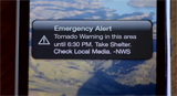
  4. What does a WEA message look like?
    WEA will look like a text message. The WEA message will typically show the type and time of the alert, any action you should take, and the agency issuing the alert. The length and language of the message received on a particular device will be dependent on the wireless network and the language setting of the device. Messages will be up to 360 characters on 4G LTE networks and beyond. WEA message length will be a maximum of 90 characters on 3G and earlier networks. Please see the current NWS WEA messages in English and Spanish.

     
    Examples of Wireless Emergency Alerts in English and Spanish.
  5. How will I know the difference between WEA and a regular text message?
    WEA messages include a special tone and vibration, both repeated twice.
     
  6. What types of WEA messages will the National Weather Service send?
    Warnings for Tsunamis (see Fact Sheet), Tornado, Severe Thunderstorm (only when the damage threat is destructive), Flash Flood (only when the damage threat is considerable or catastrophic), Hurricane, Typhoon, Storm Surge, Extreme Wind, Dust Storm and Snow Squall.
     
  7. What should I do when I receive a WEA message?
    Follow any action advised by the emergency message. Seek more details from your favorite TV or radio station, NOAA Weather Radio, news website, desktop application, mobile application, or other trusted source of information.
     
  8. Will I receive a WEA message if I'm visiting an area where I don't live, or outside the area where my phone is registered?
    Yes, if you have a WEA-capable phone and your wireless carrier participates in the program. For information about which mobile devices are WEA-capable and carrier participation, please visit: http://www.ctia.org/consumer-resources/wireless-emergency-alerts or contact your wireless carrier.
     
  9. What if I travel into a threat area after a WEA message is already sent?
    If you travel into a threat area after an alert is first sent, your WEA-capable device will receive the message when you enter the area.
     
  10. Does my cell phone have all WEA capabilities?
    Many wireless devices available since 2012 support the ability to receive and present a Wireless Emergency Alert (WEA). As WEA has been enhanced with new features, wireless devices can support WEA 1.0, 2.0 or 3.0. Some of the features supported for each WEA version include:
    • WEA 1.0 supports alerts up to 90 characters in length and only in English.
    • WEA 2.0 supports alerts up to 360 characters in length and Spanish alerts, so long as the alerting authority transmits in Spanish. Device settings may determine whether English or Spanish alerts are displayed.
    • WEA 3.0 can support geographical targeting accuracy of 0.1 mile (1/10 mile). WEA 1.0 and 2.0 devices, and in some cases 3.0 devices, cannot support this enhanced geographic targeting. In cases where WEA 3.0 is not supported, the alert may be presented, but may not be within 0.1 mile accuracy.
    For more information about WEA, please visit the Federal Emergency Management Agency (FEMA), Federal Communications Commission or CTIA. For more information about your wireless device and WEA, please visit the website of the device manufacturer or your wireless provider.
     
  11. Is this the same service public safety agencies have asked the public to register for?
    No, but they are complementary. Local agencies may have asked you to sign up to receive telephone calls, text messages, or emails. Those messages often include specific details about a critical event. WEA are very short messages designed to get your attention in an emergency situation. They may not give all the details you receive from other notification services.
     
  12. Will I be charged for receiving WEA messages?
    No. This service is offered for free by wireless carriers. WEA messages will not count towards texting limits on your wireless plan.
     
  13. Does WEA know where I am? Is it tracking me?
    No. WEA uses radio technology to broadcast the alert from cell towers to mobile devices in the area of the threat. Therefore, WEA doesn’t know exactly who is tuned in.
     
  14. Will a WEA message interrupt my phone conversations?
    No, the alert will not interrupt your call.
     
  15. How often will I receive WEA messages?
    You may receive frequent WEA messages during an emergency. Message frequency depends on the number of imminent threats to life or property in your area.
     
  16. If, during an emergency, I can't make or receive calls or text messages due to network congestion, will I still be able to receive a WEA message?
    Yes, WEA messages are not affected by network congestion.
     
  17. What if I don't want to receive WEA messages?
    You can opt-out of receiving WEA messages for imminent threats and AMBER alerts, but not for Presidential messages. To opt out, please refer to instructions from your wireless carrier or visit http://www.ctia.org/consumer-resources/wireless-emergency-alerts for more information.
     
  18. Why did I receive an alert when there was no warning in effect for my location?
    WEA messages are broadcast using radio-like technology from cell towers in, and sometimes around, the actual warning area. If your device is not capable of WEA 3.0 (see item #10 above), an alert can reach cell phones outside of the actual warning area depending on the broadcast range of the cell towers which broadcast the alert.

  19. How will I receive alerts if I don't have a WEA-capable device?
    WEA is one of many ways you can receive emergency notifications. Other sources include NOAA Weather Radio, news media coverage, the Emergency Alert System on radio and TV broadcasts, desktop applications, mobile applications, and other alerting methods offered by local and state public safety agencies.

  20. How does the NWS activate a Wireless Emergency Alert on my cell phone?

  21. The NWS pushes our suite of warnings, advisories, and watches to a national collection point called the Integrated Public Alert and Warning System (IPAWS). The NWS specially marks our most critical NWS alerts for WEA distribution, so that when they reach IPAWS, they are pushed to commercial wireless carriers who broadcast the alert from cell towers in the threat area to your cell phone. IPAWS also serves as collection point for non-weather alerts, such as civil and child abduction emergency messages which are issued by other emergency authorities. Once an alert is in IPAWS, the alert may be made available through a variety of channels for further distribution, such as broadcast over television/radio stations, sirens, display on highway signs, desktop and mobile alert software application, and the Wireless Emergency Alert system.

    WEA Factsheet (PDF) - Download a factsheet on Wireless Emergency Alerts.


Comments

  1. As always your info is must appreciated. I learn much as well. We definitely need a lot more rain in extreme west Texas and southern New Mexico. The winds overnight and this morning along the east slopes of the Franklins have been very strong, breaking limbs off trees and throwing debris, ranking up there with strong winds of spring.

    ReplyDelete
  2. Thanks. Looks like you guys got hit with the front as it backdoored east and southeast into the El Paso area. Hope you get t-storms and rain without the severe aspect.

    ReplyDelete

Post a Comment

Your comments, questions, and feedback on this post/web page are welcome.

NWS Albuquerque Burn Scar Matrix

Current National Weather Service Watches/Warnings In Effect.

New Mexico

Chaves County Plains & Mtn's

Eddy County

Culberson County

Lea County

Lincoln County

Otero County

Current US Temps

Current US Wind Chill/Heat Index Temperatures

WPC 7-Day Precipitation Forecast

Roswell Live EarthCam

Ruidoso Live Webcam

Cloudcroft Live Webcam

NWS Midland 3-Day Precipitation Forecast

NWS Midland High End 3-Day Precipitation Forecast

NWS Midland 3-Day Precipitation Chances

New Mexico 3-Day Precipitation Forecast

New Mexico 3-Day High End Precipitation Forecast

New Mexico Precipitation Chances

NWS El Paso 3-Day Precipitation Forecast

NWS El Paso High End 3-Day Precipitation Forecast

NWS El Paso 3-Day Precipitation Chances

US 24-Hour Precipitation Forecast

US 24-Hour High End Precipitation Forecast

US 24-Hour High End Precipitation Forecast

US 3-Day Precipitation Forecast

US 3-Day High End Precipitation Forecast