One More Of T-Storms & Locally Heavy Rain Then We Dry Out.


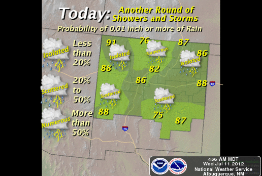


We have one more shot seeing some much needed rainfall across the local area today and tonight before we dry out and warm up. Scattered thunderstorms will once again pop up across the area today, and some of these may produce locally heavy rain, which may produce localized flash flooding. This will be especially true over and near those areas that have received heavy rain over the past couple of days, as well as over and below the burn scar areas.
If you come upon a flooded arroyo please do not attempt to dry across it. Turn Around - Don't Drown!
As we close out the work week and head into the weekend, we will gradually warm up as we dry out for a few days. Our afternoon high temperatures are forecast to climb back up into the mid 90's. This combined with the recent rainfall, and increased humidity levels, will make for some pretty muggy afternoons.
Long-range models are calling for yet another uptick in our summer monsoon activity by the first of next week. A upper-level disturbance located along the Texas Gulf Coast this morning will work its way westward, and may enhance our monsoonal flow from the south next week.
After two very long years of enduring a horrendous and historic drought, it appears that we may be seeing it release its grip on the local area. Long-range forecasts are calling for El Nino conditions to return by around August or September...so hopefully we will have a wet fall, winter, and spring ahead.
The Truth Is Stranger Than Fiction!
My Web Page Is Best Viewed With Google Chrome.


Comments
Post a Comment
Your comments, questions, and feedback on this post/web page are welcome.