Busy Fall Weather Pattern Coming Up - What About Ileana?
Looking North From St Hwy 368
Capitan Mountains - North Of Hondo, NM.
Smoke From Forest Fires To Our West.
Smoke from forest fires in Arizona and southern California is being pulled east and northeast into New Mexico this afternoon. Hazy skies will make for a beautiful sunset and sunrise tonight and Friday morning in parts of the area. Not so good though for those with allergies and breathing problems.
ECMWF 500 MB (18,000' MSL) Forecast.
ECMWF 500 MB (18,000' MSL) Forecast.
Very Fall-like Upper Air Pattern Into Next Week.
A closed mid-upper level low was centered over southern Idaho at sunrise this morning. This low is forecast to lift northeastward into southern Canada by early Saturday morning and wash out. A second stronger mid-level short-wave trough of low pressure will quickly dive southward out of the Gulf of Alaska on Friday and then into the Pacific Northwest by Saturday evening.
This storm will strengthen as it drops further southward into central California by sunrise Monday morning. It is then forecast to wobble eastward into northern Utah next Tuesday.
ECMWF Temperature Anomaly Forecast.
Valid At 6 PM MDT Monday, September 16, 2024.
6 - 10 Day Temperature Outlook.
Cold Across The Great Basin This Weekend Into Early Next Week.
A strong early-season Pacific cold front will bring much below normal temps to the Great Basin this weekend into the first of next week. By sunset next Monday temps over northern California and parts of Nevada will be some forty degrees below normal.
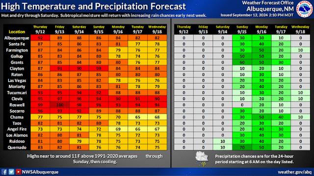
Meanwhile, here in New Mexico, our temperatures will continue above normal this afternoon into early next week. Especially in southeastern New Mexico. The exception to this will be southwestern, western, and parts of northern New Mexico early next. Near record-to-record high temps may occur today into the weekend in a few places. As of 4 PM this Thursday afternoon, the Roswell Airport ASOS had already reached 99 and Carlsbad 95. Summer is fighting to hang on.
Remnant Moisture From Tropical Storm Ileana.
A tropical depression strengthened into Tropical Storm Ileana this afternoon. At 3 PM MDT she was located about 240 miles south-southeast of Cabo San Lucas, Mexico. Illenia is moving north-northwest at 9 mph and will reach the southern tip of Baja California around noon tomorrow. At this time Ileana is not forecast to strengthen into a hurricane and will continue moving northward into the Gulf of Baja by Monday.
With a deep and cold closed low parked over the Great Basin late this weekend into early next week, and a strong southwesterly flow aloft around the base of the low, the question to be answered is how much of Ileana's remnant moisture gets pulled northward into New Mexico. And what effects will that moisture have?
Thinking as of this Thursday afternoon is that the western and northern half of the state will benefit the most from this tropical moisture plume. I think the models may be underestimating the storm's total rainfall amounts this weekend into next week. Which is not really all that unusual with tropical systems.
Scattered thunderstorms return to the Sacramento and Captian mountains Saturday and increase in coverage Sunday into the first of next week.
Locally heavy rainfall and flash flooding will be a concern in areas most impacted by Ileana's remnant tropical moisture late this weekend into early next week. Keep abreast of your local forecasts and be ready for possible changes to existing forecasts as the weather pattern unfolds this weekend into early next week.
Severe thunderstorms may dot the landscape of the eastern one half of the state next Tuesday as the strong Great Basin storm moves closer and a sharp dryline forms over the eastern plains of the state.
Weather Prediction Center 7-Day Rainfall Forecast.
ECMWF Snowfall Forecast.
There Are None So Blind As Those Who "Will - Not" To See...107.


Comments
Post a Comment
Your comments, questions, and feedback on this post/web page are welcome.