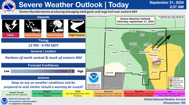
An Active Day For Severe T-Storms In NE/E/SE NM.
Just Outside Of Carrizozo, NM.
Weather Prediction Total Rainfall Forecast.
Today.
Sunday.
Monday.
Tuesday.
Wednesday.
A deep upper-level closed low was located over southwestern Arizona at midnight last night. This low is forecast to lift northeastward to the Four Corners Region by sunset this evening.
A cold front will be pushing southward into northeastern New Mexico this afternoon and evening, then into southeastern New Mexico and West Texas by around sunrise Sunday morning.
Strong lift, good instability, low-level southeasterly upslope flow from the Gulf of Mexico, and along and behind the frontal boundary, the drylinie draped over southeastern New Mexico, all will play a role today into tonight in producing scattered severe thunderstorms across northeastern, eastern, and southeastern New Mexico, and parts of West Texas.
Scattered thunderstorms will develop early today and quickly become severe in these areas. They will be capable of producing large hail, damaging thunderstorm wind gusts in excess of 58 mph, frequent cloud to ground lightning, locally heavy rainfall and localized flash flooding.
Scattered supercell thunderstorms are expected and the stronger of these will be capable of producing a few tornadoes. Especially along the southward advancing cold front and along and east of the dryline.
A Flood Watch is in effect from noon today through late tonight for the Southern Sangre de Cristo mountains, east slopes of the Sangre de Cristo mountains, and the northeast Highlands of New Mexico.
Localized flash flooding will also be possible with the stronger supercell thunderstorms and any training thunderstorms this afternoon into tonight across eastern and southeastern New Mexico. And across the burn scar areas in the Sacramento mountains.
Stay alert and weather aware today and be ready to seek shelter in the event that severe weather approaches or threatens your location or area. Especially with any outdoor activities taking place. Local storm total rainfall amounts of 1" to 3" are possible today into tonight.
On a side note Winter Weather Advisories have been issued for parts of western and northwestern Colorado for tonight into Sunday. Up to 8" of snow is forecast. It won't be long before we start seeing this in New Mexico.
Good news temperature-wise. Highs today in southeastern New Mexico will be in the low 90's ahead of the approaching cold front from the north. Behind it tomorrow near 80 to the mid 80's. The mid-upper 70's to near 80 on Monday and Tuesday, and the mid-upper 70's on Wednesday behind another reinforcing shot of cooler air.
The Ruidoso area will see the low-mid 70's today into next Tuesday, and the upper 60's next Wednesday.
The Cloudcroft area will see the low-mid 60's today into next Tuesday, and the upper 50's next Wednesday.
Rather reluctantly summer is finally giving it up and losing the battle temperature-wise. Sunday marks the calendar beginning of fall although the meteorological or climatological beginning of fall occurred on September 1st.
There Are None So Blind As Those Who "Will - Not" To See...107.


Comments
Post a Comment
Your comments, questions, and feedback on this post/web page are welcome.