Hope For More Snow Comes This Week.
Just east of Cloudcroft, New Mexico.
A snow drought continues across the Sacramento, Capitan, and Guadalupe mountains. To date, (Oct 1, 2020 - Jan 17, 2021) Cloudcroft (8,750') has only received 5.5" of snowfall all season long. The long-term average (Oct-Apr) is 90.0".
Blog Updated At:
1051 AM MST Sunday, Jan 17,2021.
Two Winter Storms This Week?
Winter storm #1 is forecast to develop late tonight into early Monday morning over northern and central California. Then continue to deepen and strengthen as it drops southward to west of San Diego, California by sunset Monday. Meanwhile, winter storm #2 is forecast to develop over the northern and central Rockies tonight into Monday. By sunset Monday it should be impacting much of Colorado, western, northern, and central New Mexico with colder temperatures and snow...some of which may be heavy.
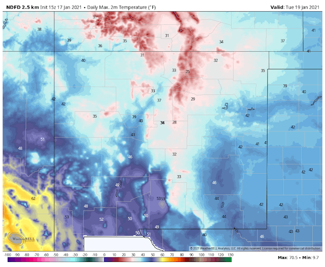
Valid At 5 AM MST Tuesday, January 19, 2021.
A southward moving cold front will surge through the state on Monday afternoon into early Tuesday morning. Colder temperatures will accompany the frontal passage Monday night into Wednesday.
Today.
Monday.
Tuesday.
NWS NDFD Total Snowfall Forecast.
Monday Night Into Wednesday Morning.
The Sacramento and Capitan mountains look to pick up around 1" to 3" of snow with possibly 4" to 6" at the higher elevations by Wednesday morning. Late next week as the second winter storm impacts the area they could get this much again, maybe more. By next weekend it's possible that Cloudcroft may have gotten a foot of new snow...more than they have had all season long so far.
NWS NDFD Total Precipitation Forecast.
Monday Night Into Wednesday Morning.
Round #1 comes Monday night into Tuesday as the two closed mid-upper level lows to our combine into one storm and then parks itself southwest of San Diego, west of northern Baja into Thursday. Round #2 comes Thursday night/Friday into the weekend. But the details of this second winter storm to impact the area are fuzzy at the moment.
The Truth Is Stranger Than Fiction!


Comments
Post a Comment
Your comments, questions, and feedback on this post/web page are welcome.