Northern & Central New Mexico Winter Storm Today Into Saturday Afternoon.
South Of Cloudcroft, NM.
Northern & Central New Mexico Winter Storm Today Into Saturday Afternoon.
.SYNOPSIS...
Issued at 246 AM MST Fri Nov 24 2023

A storm system will cross today through Saturday with widespread
rain and snow showers. The snow level will drop near 3500 feet in
elevation tonight.
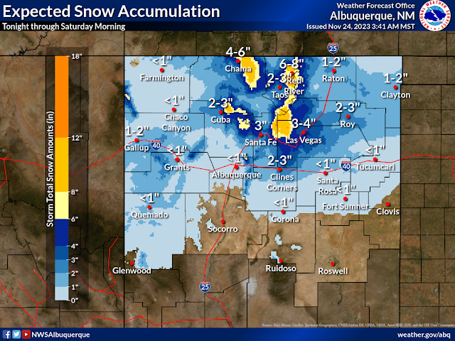
A few to several inches of snow are forecast to
accumulate across much of northern, west central, and central New
Mexico tonight through Saturday morning, except for little or no
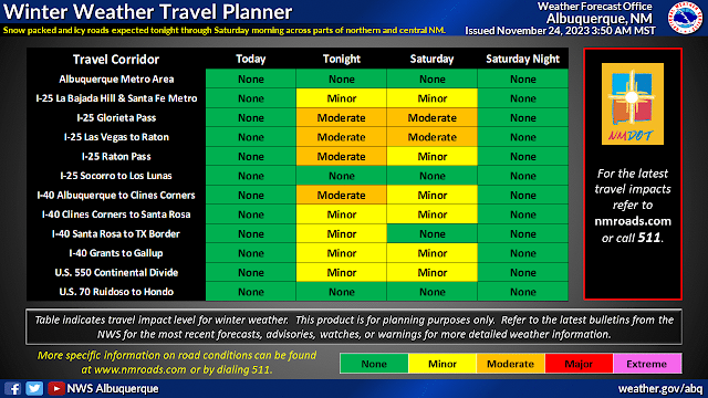
accumulation in Farmington, Albuquerque, and Tucumcari.Travel will be impacted on many roadways along and north of I-40. High temperatures will plummet today through Sunday, and although
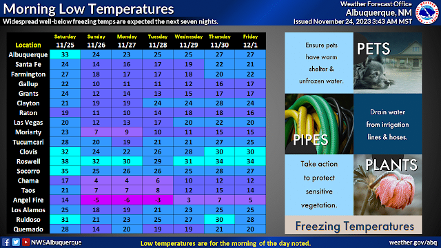
readings will modify some, they will remain below 1991-2020
averages in most places through coming work week. After dry weather Sunday through Wednesday, the chance for rain and snow
showers will return mainly to western areas starting Thursday.RTMA Apparent Temperatures.
New Mexico NWS MesoWest Wind Chill Temperatures.
Brrrr...It's A Cold Black Friday Morning!
An backdoor arctic cold front has moved southward and westward through the eastern one third of New Mexico overnight into this morning. Temperatures across northeastern New Mexico as of 9 AM MST are in the teens and 20's with wind chill temps in the single digits.
Low clouds, as seen on the visible satellite image, are banked up against the central mountain chain, and southward along the east slopes of the Sacramento, Capitan, and Guadalupe mountains. As well as across the northeastern, eastern, and parts of the southeastern plains as of 9 AM this morning.
Highs today will be chilly across the southeastern plains and will range from the 40's to the 50's. Highs on Saturday will warm a little up into the 50's and 60's. Then cool again Sunday and Monday into the 40's and 50's.
The Sacramento, Capitan, and Guadalupe mountains will see highs in the 30's and 40's today into the weekend.
A few light rain and or snow showers may break out over parts of the southeastern plains tonight but nothing significant is anticipated at this time.
At sunrise this morning a closed mid-upper level low was centered over central Nevada. It is forecast to move southeastward and then eastward across northern New Mexico and Colorado today and tomorrow. Saturday night into Sunday the the closed low is forecast by the models to open up, then pivot northeastward, dragging a shortwave trough across the state into Sunday.
Winter Storm Warnings are in effect today through Saturday afternoon. The Sangre de Cristo, and Tusac mountains of northern New Mexico are expecting to get up to 8" to 12" of new snowfall from this storm. With over a foot on some of the higher westward facing slopes.
Winter Weather Advisories are in effect today through Saturday afternoon for parts of northern one third of New Mexico. New snowfall totals will range from 1" to 3" across some of the lower elevations and up to 3" to 6" for some of the higher elevations in this area of the state.
At this time (as of 9 AM MST Friday morning) there are now watches, warnings, or advisories in effect for the southeastern plains, or the Sacramento, Capitan, and Guadalupe mountains.
Current NWS forecasts call for less than an inch of snowfall in Ruidoso and Cloudcroft today through Saturday. Ski Apache is forecast to get between 1" to 3" of new snow from this storm. It's always possible that these locations might see a little more snow than what is currently forecast should the storm to our northwest slide further south. But at this time nothing major is anticipated.
There Are None So Blind As Those Who "Will - Not" To See...107.


Comments
Post a Comment
Your comments, questions, and feedback on this post/web page are welcome.