


Changes In Our Weather Blowing In The October Wind.

Alamo Peak South Of Cloudcroft.
Fall In New Mexico Is Beautiful!
Fall in New Mexico is a gorgeous time of the year. The weekends are filled with all kinds of outdoor activities. Thousands hit back roads of the state to view (leaf peepers) the changing colors in the high country. Specifically the aspens. We did this on Friday when I took my cover photo south of Cloudcroft, high in the southern Sacramento mountains, near Alamo Peak.
October is a time of transition from the last gasps of summer to the first hints of winter. Our annual summer monsoon died in September leaving many of us with below-normal rainfall. It can still be downright hot across the lower valleys as has been the case since September. Unusually so for the southeastern and eastern plains. The 90's have been prevalent instead of our normal near 80-degree high temps.
Reported Highs On Saturday, October 12, 2024.


Albuquerque Intl Airport ASOS 86. The old record of 87 in 1979 still stands.
Roswell Industrial Air Center ASOS 97 beats the previous record of 95 in 1979.
Carlsbad Airport ASOS 95. The old record of 97 in 1979 still stands.
Elk NWS Co-Op Station 86 beats the previous record of 85 in 1979.
Cloudcroft NWS Co-Op Station 69. The old record of 71 in 1955 and 1996 still stands.
El Paso Intl Airport ASOS 94 beats the previous record of 93 in 1975.
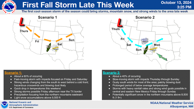
Nothing lasts forever even in the weather world. This upcoming week's weather will demonstrate that. A deep, cold closed upper-level low associated with a long wave trough in the Gulf of Alaska (this morning) will send a series of disturbances southeastward into the desert southwest by the end of this upcoming week. This will produce changes but the question is what will those changes be and how significant.

ECMWF 500 Millibar (18,000' MSL) Forecast.


ECMWF 7-Day Total Snowfall Forecast.

 Valid At 6 PM MDT Sunday, October 20, 2024.
 Valid At 6 PM MDT Sunday, October 20, 2024.


NWS NDFD Low-Temperature Forecast Wednesday Morning.


Valid At 6 PM MDT Sunday, October 20, 2024.
National Blend Of Models (NBM) 7-Day Total Precipitation Forecast.

National Blend Of Models (NBM) 7-Day Total Snowfall Forecast.

Monday.

Tuesday.

Wednesday.

Thursday.

Friday.

NWS NDFD Low-Temperature Forecast Wednesday Morning.


Cooling Down With Lowland T-Storms/Rain & Higher Mountain Snows Returning.


Our first cold front that will start the cooling process arrived earlier today. Not much in the way of significant cooling has occurred. Our highs this afternoon will range from near 90 to the low 90's. The upper 80's are forecast on Monday and Tuesday. A second and stronger cold front arrives Tuesday afternoon and evening. Our highs on Wednesday and Thursday will be in the mid to upper 70's. The low 80's are expected on Friday and the mid-upper 70's are forecast for next weekend. A stronger and further south storm track will mean colder than advertised/forecast temperatures late next week. Either way by the end of next week we will drop down to seasonal averages if not below.
As the backdoor cold front slides westward through the mountain central mountain passes and gaps Tuesday evening into Wednesday morning, strong easterly winds along with areas of blowing dust will develop. This includes the Albuquerque metro area into Wednesday morning. Strong southwesterly winds will begin to pick up areawide later next week as the storm in the Gulf of Alaska dives into the Four Corners Region.
By the end of next week, our chances for rain showers, scattered thunderstorms, and higher mountain snows (western and northern New Mexico) will be on the increase. As a deep, cold, closed upper-level low settles into the area. Just how far south it digs and how long it hangs around will dictate who gets rain and or snow and how much. The GFS model forecasts are currently wetter for the area than the Euro model.
Strong to possibly severe thunderstorms may dot the eastern and southeastern plains late next week. Along with areas of heavy rainfall.
A mix of rain and snow showers looks possible across the higher elevations of the Sacramento Mountains Wednesday night into Thursday. And again Friday night into next weekend. Snow levels at this time (as of Sunday afternoon) will likely be above 9,000'. How high or how low the actual snow levels across the state are will be highly dependent upon the track, speed, and location of the incoming storm.
This pending strong fall storm is a week away so there will be changes in the forecast models as well as in our local forecasts so stay tuned. Summer fought a hard battle but it is finally getting the boot. Winter may make an early appearance in some of the higher northern and western mountains of the state late next week into the weekend.
Our normal first freeze of the season across the southeastern plains typically occurs the last week of October into the first week of November. Tis the season so let's do this.
There Are None So Blind As Those Who "Will - Not" To See...107.


Comments
Post a Comment
Your comments, questions, and feedback on this post/web page are welcome.