Summer Has Finally Given Up - Here Comes Fall.
Cloudcroft, New Mexico.
Don't forget to fall back, or set your clocks back, an hour this Sunday morning at 2 AM.
Summer Has Finally Given Up - Here Comes Fall.
ECMWF 500 MB (18,000' MSL) Forecast.
National Blend Of Models (NBM) Storm Total Precipitation Forecast.
Valid Friday Through Election Night.
Weather Prediction Center (WPC) Storm Total Precipitation Forecast.
Weather Prediction Center (WPC) Storm Total Precipitation Forecast.
ECMWF Storm Total Snowfall Forecast.
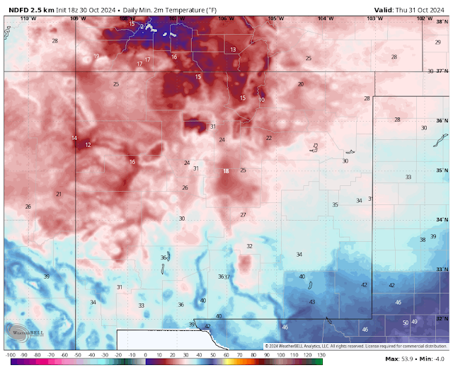
Widespread Freeze Tonight.
A Pacific cold front moving through southeastern New Mexico early this afternoon will move east and out of the local area tonight. Behind it a much colder airmass is moving southeastward. At noon today temperatures ranged from the 30's and 40's across western and northern New Mexico to the 70's across the southeastern plains. High temps yesterday afternoon reached the 90-degree mark in Roswell and Carlsbad.
Strong southwesterly winds raked the state yesterday afternoon along with areas of blowing dust. Several Dust Advisories were issued for Chaves County and parts of southern New Mexico.
The Roswell Industrial Air Center Airport ASOS clocked a peak wind gust Tuesday afternoon of 67 mph. Blowing dust obscured the sky during the afternoon and dropped the visibility down to 1/4 of a mile at times. A gust to 66 mph was recorded at the Sierra Blanca Regional Airport and the Smokey Bear Raws in Ruidoso clocked a gust to 60 mph. The San Augustin Pass Raws east of Las Cruces on US Hwy 70 clocked a gust to 82 mph.
As the latest fall storm that produced our high winds, blowing dust, and higher northern mountain snow showers departs today another stronger storm is organizing over the Gulf of Alaska today. It will dive southward and strengthen carving out a large long-wave trough of low pressure over the western U.S. Friday into the weekend. By next Monday a strong upper-low is forecast to be located over central New Mexico.
Our first widespread freeze of the season will impact much of the state late tonight into early Thursday morning. Low temps Thursday morning will likely be in the 20's and 30's over much of the state. The teens are forecast for the far northern mountains.
Lows across the southeastern plains will be in the 30's to near 40. The Roswell, Dexter, Hagerman, Artesia, Lakewood, Seven Rivers, and Tatum areas will get very close to seeing their first freeze. The Carlsbad area may escape it though.
T-Storms Return Friday Night Into The Weekend.
Snow Over Western & Northern New Mexico Late This Weekend.
Low-level moisture born upon southeasterly upslope flow will quickly return to the southeastern plains on Friday. The atmosphere will destabilize with a strong southwesterly flow aloft setting up ahead of the approaching storm to our northwest. A dryline will likely setup along the east slopes of the Capitan, Sacramento, and Capitan mountains Friday afternoon into Saturday night.
Scattered rain showers and thunderstorms will be on the increase across the eastern and southeastern plains and nearby mountains Friday evening into Saturday night. Some of these may become severe over the eastern and southeastern plains. Locally heavy rainfall and localized flash flooding will also be a concern. However, I do not see anything in the computer model forecasts at this time, that indicates that another excessive rainfall event such as the devastating Roswell area event is in the making. It is early so specific rainfall forecast totals are not reliable this far out in time. The different models have different outcomes so don't get too caught in the model rainfall forecasts yet.
As a strong closed or upper-level low settles into the state late this weekend into next Monday scattered rain showers and snow showers will overspread parts of western and northern New Mexico. There is the potential for heavy mountain snow in some of these areas. More on this later.
Snow levels may drop as low as around 7,000' Monday night in the Sacramento mountains. Ski Apache may see their first accumulating snowfall of the season on Monday and Monday night.
Long-range forecasts call for a period of below normal temps and wetter-than-normal conditions over the state over the next two weeks.
There Are None So Blind As Those Who "Will - Not" To See...107.


Comments
Post a Comment
Your comments, questions, and feedback on this post/web page are welcome.