Severe T-Storms - Very Heavy Rainfall/Flash Flooding - Heavy High Mtn Snowfall
South Of Cloudcroft, NM.
Blog Post Updated At 12:29 PM MDT Saturday, October 19, 2024.
Blog Post Updated At 11:06 AM MDT Saturday, October 19, 2024.
Potent Cut-Off Low Will Produce Wild Wx Over NM Today Into Sunday.
Valid Today Through 6 AM MDT Tuesday.
NWS NDFD Forecast Storm Total Snowfall Amounts.
Valid Today Through 6 AM MDT Tuesday.
ECMWF Forecast Storm Total Snowfall Amounts.
As Of 7 AM MDT Saturday, October 19, 2024.
The Set Up.
A potent cut-off upper-level low will basically park itself over Arizona today through Sunday. It will wobble around Arizona today into Sunday. By sunset Sunday it is forecast to start opening up and lifting northeastward into the Four Corners. And then into eastern Colorado on Monday.
At the surface, a quasistationary front located in northeastern New Mexico will intersect a Pacific cold front in western New Mexico...both moving little today. The Pacific front will slide eastward across the state Sunday night into Monday morning.
Abundant low-level Gulf of Mexico moisture has been imported into the eastern one-half of the state borne upon stiff southeasterly winds. Surface dew point temperatures are in the 50's and 60's. Low clouds envelop the eastern side of the state in this rich moisture field.
Yesterday and overnight scattered t-storms dumped heavy rainfall on some locations in central, north-central, and northeastern New Mexico. Reports indicate that 1" to 3" fell in some spots.
Today & Tonight.
Once the sun works its magic and the low clouds over the eastern one-half of the state burn off the atmosphere will become primed for the development of severe thunderstorms. Several lines or clusters of severe thunderstorms may develop this afternoon into tonight. Scattered supercell thunderstorms are forecast to develop ahead of this line today into tonight.
The atmosphere will become very unstable today. This morning's 6:45 AM MDT Severe Weather Outlook for today courtesy of the Storm Prediction (SPC) calls for the best window of opportunity for severe thunderstorms to occur between around 5 PM to 9 PM MDT this afternoon and evening. This does not mean that severe thunderstorms cannot or will not develop before that time frame.
Outside of the severe weather threat areas scattered rain showers and thunderstorms will dot the landscape of the state today into Sunday.
Severe T-Storms:
Scattered Supercell thunderstorms across the eastern one-half of the state (including southeastern New Mexico), from the central mountain chain eastward, will have the potential to rapidly intensify once they develop. These dangerous thunderstorms on steroids will be capable of producing large to very large hail, damaging thunderstorm wind gusts in excess of 58 mph, deadly lightning strikes, heavy to very heavy rainfall, and flash flooding.
Due to a very unstable atmosphere, a strongly sheared wind environment from the surface to around 40,000' MSL, and low cloud bases in the abundant low-level moisture, tornadoes may also develop with the strongest supercell thunderstorms.
It is fairly uncommon but not rare to have this type of setup in October in New Mexico. Today will be one of those days that you will need to pay very close attention to your local weather conditions. Pay attention to any National Weather Service Watch or Warning that will likely be issued across the state today into tonight. Be on the alert and ready to seek shelter in the event that a severe thunderstorm or tornado approaches your location. Some locations may see multiple rounds of severe thunderstorms today into tonight.
Heavy To Very Heavy Rainfall - Flash Flood Threat:
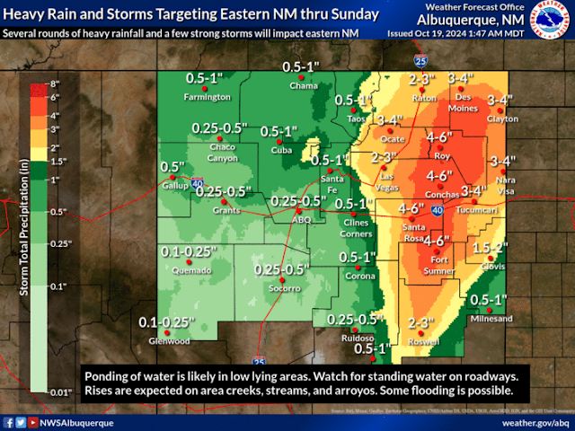
Heavy to very heavy rainfall will cause issues across the state today into tonight as well. A Flood Watch remains in effect for north-central, northeastern, eastern, and parts of southeastern New Mexico through Sunday Forecast storm total rainfall amounts in some areas of northeastern, eastern, and parts of the eastern plains are in the 2" to 6" range.
Flash flooding will be a concern in the Flood Watch area today into tonight. This includes Lincoln and Chaves Counties. As has been the case since this summer the Burn Scar areas around Ruidoso will have the highest threat for flash flooding as well as the Hermits Peak, and Calf Canyon Burn Scars.
Winter Weather:
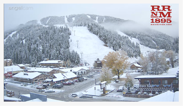
A Winter Weather Advisory remains in effect through Noon MDT Sunday for the northern Sangre de Cristo mountains. 2" to 6" of new snowfall is forecast below 10,000' and 6" to 12" is forecast above 10,000'.
Heavier snowfall reports this morning include.:
A report of 8" of new snow 5 miles west-northwest of Eagle Nest Lake, Taos Ski Valley 7", 7" south-southwest of Toadlena in San Juan Co, 4" in Cibola, and 2" 5 miles south of Cimarron in Colfax Co.
As far as the Sacramento mountains are concerned snow has been removed from the forecasts due to the expected high snow levels. Ski Apache could possibly see a mix of rain and snow Sunday night. But as of this Saturday morning, no significant accumulations are forecast.
Since we have a cut-off upper-level low (cut off from the jet stream flow to the north) we have an ornery storm to deal with. These types of storms can and are cantankerous and have been known to wreak havoc on forecasts. So do not be surprised if there are changes in some of our forecasts. Some areas may get more rain and snow than currently forecast, some less.
Sunday looks like it could be another repeat of what we experience today.
Stay safe, have a good weekend, enjoy the rain and snow if possible, and stay alert. As always visit my weather web page for all the latest weather info.
There Are None So Blind As Those Who "Will - Not" To See...107.


Comments
Post a Comment
Your comments, questions, and feedback on this post/web page are welcome.