A Cold Front & T-Storms For The Weekend.
Between Ruidoso & Cloudcroft.
Mescalero Apache Indian Reservation.
European (ECMWF) 500 MB/18,000' MSL Forecast.
Welcome To Fall.
At least the beginning of the meteorological fall anyway. Just like that our summer monsoon got shut down a week ago. Our old summer nemesis the Four Cornes Mid-Level Death Ridge returned to the region and cut off our monsoonal flow from the south. Thus the airmass over New Mexico has dried out and warmed up.
Looking at the Euro models 500 millibar or roughly the 19,000' Mean Sea Level (MSL) forecast for noon today we find it centered over the Four Corners Region. Lurking below and to the southwest of the southern tip of the Baja Peninsula is Hurricane Kay.
Looking at the Euro models 500 millibar or roughly the 19,000' Mean Sea Level (MSL) forecast for noon today we find it centered over the Four Corners Region. Lurking below and to the southwest of the southern tip of the Baja Peninsula is Hurricane Kay.
With a drier airmass in place of the state, clear skies, light winds, and radiational cooling at night our overnight low temps are coming down. The Angel Fire Airport dipped down to freezing this morning. The Eagle Nest NWS Climate Co-Op Stations' average low temp for Sept 7th is 38ºF.
Cloudcroft dropped down to 41ºF this morning compared to an average for the date of 44ºF. The Mescalero Raws and the Smokey Bear Raws came in with 48ºF and 49ºF. The average low for the date in Ruidoso is 47ºF.
Cloudcroft dropped down to 41ºF this morning compared to an average for the date of 44ºF. The Mescalero Raws and the Smokey Bear Raws came in with 48ºF and 49ºF. The average low for the date in Ruidoso is 47ºF.
Our lows here in the Pecos Valley and surrounding locations across the Southeastern Plains have been in the 60's the last several mornings. With Artesia coming in at 57ºF the past two mornings. The low 60's are average for the local area for the date.
These cooler mornings are another sign that fall is slowly creeping upon us. Our afternoon high temps are running close to seasonal norms for the date.
If you take a look at the Euro's 500 millibar forecast map above you will notice a series of short wave troughs of low pressure dipping south into the Gulf of Alaska, the Pacific Far Northwest, and across the Hudson Bay area of Canada. As the season slowly slides into more fall-like conditions the jet stream becomes stronger with time.
And with time it sends these mid-upper level storms further and further south into the US. These disturbances are often accompanied by southward or eastward-moving cold fronts. Such will be the case this weekend as a cold front slides south through New Mexico late Saturday into Sunday. Our high temps behind this front will drop down into the 80's Sunday and Monday here in Southeastern New Mexico.
And with time it sends these mid-upper level storms further and further south into the US. These disturbances are often accompanied by southward or eastward-moving cold fronts. Such will be the case this weekend as a cold front slides south through New Mexico late Saturday into Sunday. Our high temps behind this front will drop down into the 80's Sunday and Monday here in Southeastern New Mexico.
Cooler temps also return to the mountains with highs Sunday and Monday in the Ruidoso area only in the low-mid 70's. The Cloudcroft area will only see highs in the low 60's.
At 3 PM MDT Wednesday.
National Blend Of Models (NBM)
Forecast High Temperatures Thursday.
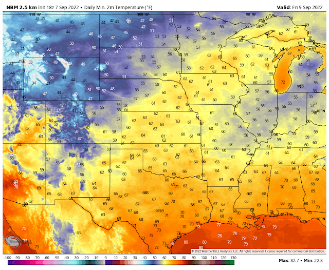
Montana saw high temps Wednesday afternoon above 105ºF. With the frontal passage, they will only see highs on Thursday in the 70's. Lows Friday morning will be in the 40's. In time these cold fronts will continue to get stronger and bring cooler/colder temps further south.
T-Storms Return With The Cold Front.
Scattered thunderstorms and rain showers are slated to return to the area Saturday afternoon into next Tuesday. These will be of the hit-and-miss variety mostly. The cold front will cause low-level upslope easterly flow to return and act as a focus for thunderstorm development. Indirectly Hurricane Kay will send some of her remnant moisture northeastward into the state to add to the equation late this weekend into the first of next week.
Valid At Sunrise Thursday Morning.
Hazy, smoky skies returned to much of the region this morning. We will see a repeat tonight through Thursday. Smoke from forest fires in the northern Rockies is being carried aloft and southward into our local area by northerly and northeasterly winds above the surface.
There Are None So Blind As Those Who "Will - Not" To See...107.


Comments
Post a Comment
Your comments, questions, and feedback on this post/web page are welcome.