

One More Day Of T-Storms Then The Monsoon Gets Shutdown Again.

Near Sitting Bull Falls.
Southwest Of Carlsbad, NM.
NWS Albuquerque Fall Equinox Feature.
NWS Albuquerque Fall Equinox Feature.
New Mexico is no stranger to active fall weather. The
transition from summer to winter brings delightful
relief to the blistering heatwaves of summer. The fall
transition is also associated with a wide variety of
weather as the jet stream starts visiting the region
from the north. Cold blasts, damaging wind storms,
severe thunderstorms, heavy snow, and flash flooding
can all occur during the fall months, sometimes all on
the same day! Fall also brings a glorious display of
changing foliage to many areas of the state.

As Of 8 AM MDT
Tuesday, September 20, 2022.
MRMS 72-Hour Rainfall Totals.
MRMS 72-Hour Rainfall Totals.


As Of 8 AM MDT
Tuesday, September 20, 2022.
New Mexico NWS MesoWest 72-Hour Rainfall Totals.
New Mexico NWS MesoWest 72-Hour Rainfall Totals.


(As Of 8 AM MDT Tuesday, Sept 20, 2022).


As Of 8 AM MDT
Tuesday, September 20, 2022.
(As Of 8 AM MDT Tuesday, Sept 20, 2022).

Decent Rainfall For Some The Past Three Days.
Scattered to numerous thunderstorms have dotted the landscape across the southern desert, Tularosa Basin, and the Sacramento mountains the past three days. Some of the heavier three-day totals include:
Lincoln CoCoRaHS Station located 1.4 miles east-southeast 2.92".
Mayhill - Cool Pines RV Park Personal Weather Station (PWS) northwest of Mayhill 2.32".
Ruidoso Downs Personal Weather Station (PWS) located southeast of Ruidoso Downs 2.10".
Bell Canyon Personal Weather Station (PWS) located northwest of Mayhill 2.09".
High Rolls Personal Weather Station (PWS) southeast of High Rolls 2.03"
Cloudcroft CoCoRaHS Station located 4.0 miles east 2.01"
Mayhill - Lazy Day Cabins Personal Weather Station (PWS) 1.83"
Cloudcroft NWS Climate Co-Op Station 1.83".
Dunken Raws 1.38".
Ruidoso - Forrest Service Rd 120 HADS 1.20"
Timberon Personal Weather Station (PWS) 1.51"
Alto CoCoRaHS Station located 0.3 miles north 1.50".
Cloudcroft CoCoRaHS Station located 0.4 miles east-southeast 1.35".
Arabella CoCoRaHS Station located 2.5 miles south-southwest 1.27".
Arabella CoCoRaHS Station located 2.5 miles south-southwest 1.27".
Ruidoso CoCoRaHS Station located 1.4 miles south-southwest 1.24".
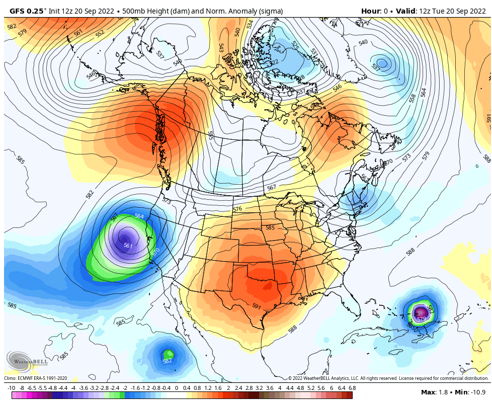
We Dry Out & Stay Warm Until Sunday.
Our recent round of thunderstorms will come to an abrupt end after today. Our persistent stubborn mid-upper level ridge of high pressure depicted above will shift a little further to the west thus shutting down our monsoonal flow from Mexico.
The forecast for the rest of the week calls for high temps a little above seasonal normals today into the upcoming weekend. Highs will range from the low to mid 90's across the southeastern plains and the southern deserts to the upper 70's in the Ruidoso area and the upper 60's in the Cloudcroft area.
The forecast for the rest of the week calls for high temps a little above seasonal normals today into the upcoming weekend. Highs will range from the low to mid 90's across the southeastern plains and the southern deserts to the upper 70's in the Ruidoso area and the upper 60's in the Cloudcroft area.
A seasonally fall-like cold front will arrive in the local area this coming Sunday. Although it won't bring significant cooling to the local area it will drop our daytime highs and nighttime lows down to slightly below normal by the beginning of next week.
Watching The Gulf.


A tropical wave has developed a few hundred miles east of the Windward Islands. This system has an 80% chance of developing into a Tropical Storm over the next five days. We will have to keep an eye on its potential track and strength to see whether or not it ends up in the Gulf of Mexico as a Hurricane by the end of the weekend or next week.
There Are None So Blind As Those Who "Will - Not" To See...107.


Comments
Post a Comment
Your comments, questions, and feedback on this post/web page are welcome.