


Another Prolonged Widespread High Wind - Blowing Dust Event!

Sierra Blanca Peak.
Looking East From Near Three Rivers.

Valid At 5 PM MST Tuesday.

Another Prolonged Widespread High Wind - Blowing Dust Event!
Our windy season has kicked off early. Yet another prolonged widespread high wind - blowing dust event is slated to hammer New Mexico and nearby areas today into Wednesday. Especially on Wednesday!
But first let's talk about the rains that have fallen over the past three days. While not everyone has received measurable precipitation locally, others have, and some of those reports are impressive given the time of the year. And the Sierra Blanca Snotel Station is reporting a 24-hour snowfall total of 17.0" of snow with 1.60" of precipitation. Very dense fog reduced the visibility down to near zero over parts of the Sacramento mountains overnight into this morning...A Dense Fog Advisory was issued by the El Paso National Weather Service Office.
(As Of 9 AM MST Monday, Feb 20, 2023).


Selected Heavier New Mexico 72-Hour Precipitation Totals.
(As Of 9 AM MST Monday Morning).
Alto CoCoRaHS Station 7.4 W 2.59"
Cloudcroft CoCoRaHS Station 1.8 SW 1.77"
Cloudcroft CoCoRaHS Station 2.3 S 1.50"
Rio Ruidoso At Ruidoso HADS 1.49"
Sierra Blanca Snotel 1.20"
Cloudcroft CoCoRaHS Station 0.4 ESE 1.13"
Smokey Bear Raws - Ruidoso 1.09"
Pine Springs Raws - Guadalupe Mtn's Natl Park 1.00"
Alto Water Treatment HADS .90"
Sunspot CoCoRaHS Station 0.2 SSW .72"
Timberon PWS .71"
Alto CoCoRaHS Station 0.3 N .70"
Reported 24-Hour Peak Wind Gusts.
(As of 9 AM MST Monday, February 20, 2023).
Pine Springs West Texas MesoNet Station 75 mph.
Carlsbad Airport ASOS 63 mph at 5:25 PM MST Sunday.
Raton Crews Airport 63 mph.
Pine Springs Raws 63 mph.
Bowl Raws 63 mph.
Vaughn 60 mph.
Bat Draw Raws - 57 mph.
Scattered rain showers will dot the landscape off and on today through Tuesday night across the southern one half of the state. A few isolated thunderstorms with moderate rainfall is possible through tonight across parts of southwestern and southern New Mexico.
NWS Watches/Warnings In Effect.


At 5 AM MST Monday, February 20, 2023.
GFS 500 MB (18,000') Analysis.

At 11 AM MST Wednesday, February 22, 2023.
Windy Today Into Wednesday - Main Event Wednesday.
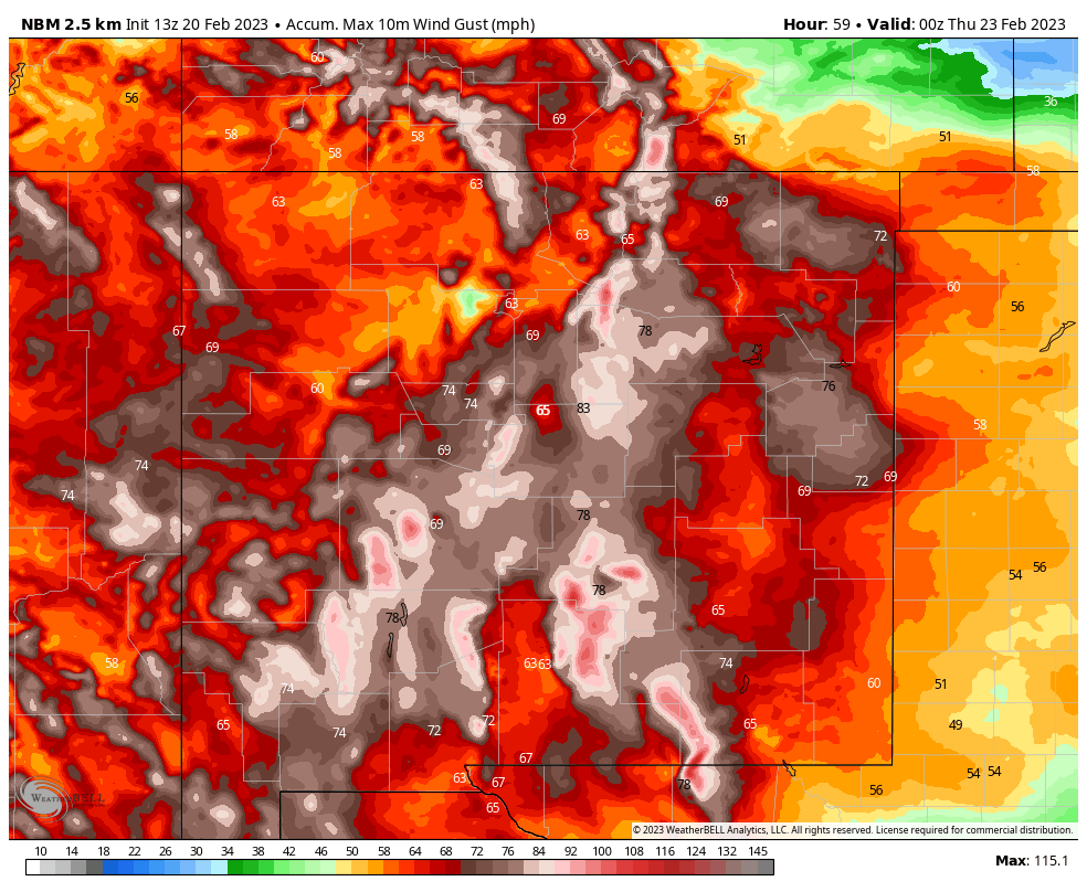
NBM Peak Wind Gust Swath Forecast Wednesday.
A cut off mid/upper-level low current off of the southern California Coast is the culprit behind our recent rain and snowfall over the area. This low will gradually weaken and open up as it moves northeast across Southeastern New Mexico Tuesday night.
Meanwhile, a deep, cold, and very strong mid/upper-level closed low is forecast to develop over far Northwestern British Columbia and the Pacific Northwest tonight into Tuesday. This powerful winter storm will then drop slowly southward into the Great Basin. By sunrise Wednesday it is forecast to be centered over eastern Nevada.
Meanwhile, a deep, cold, and very strong mid/upper-level closed low is forecast to develop over far Northwestern British Columbia and the Pacific Northwest tonight into Tuesday. This powerful winter storm will then drop slowly southward into the Great Basin. By sunrise Wednesday it is forecast to be centered over eastern Nevada.
This monster of a winter storm will be accompanied by very strong jet stream wind speeds traversing the state and area on Wednesday. Forecast models indicate that a jet stream winds at the 30,000' level (300 millibars) will be in the neighborhood of 150 knots or near 175 mph Wednesday. At the 18,000' level (500 millibars) these winds are forecast to be around 115 to 120 knots or around 130 to 140 mph. At 10,000' (700 millibars) above sea level jet stream winds of 50 to 80 knots or around 60 to 90 mph are forecast.
At the surface a Pacific cold front will swing across the state on Tuesday. With a stronger Pacific cold front arriving Wednesday and exiting the state by Thursday. A deep surface low will develop over southeastern Colorado Tuesday night and Wednesday. A strong surface pressure gradient along with deep mixing of the winds aloft to the surface will all combine to produce this high wind event.
Translation. A prolonged, widespread, significant high wind/blowing dust event looks to be shaping up for much of New Mexico and nearby areas. Wind Advisories, High Wind Watches, and High Wind Warnings have already been hosted for much of the southern and eastern areas of the state for today. Except to see these expand in aerial coverage on Tuesday with many of these same areas likely upgraded to High Wind Warnings.
In fact the El Paso NWS Office already has a High Wind Watch in effect from late Tuesday night through late Wednesday night for the southern Sacramento mountains above 7,500'. This includes the Cloudcroft, Sunspot, Silver Lake, 16-Springs Canyon, and Wimsatt areas. Southwest winds are forecast to become sustained at 40 to 60 mph with gusts up to 95 mph!
Below 7,500' southwest are forecast to become sustained at 30 to 50 mph with gusts up to 75 mph! This includes the High Rolls, Mountain Park, Mescalero, Timberon, Pinion, Sacramento/Weed, Mayhill, Elk, and Dunken areas.
These winds will be capable of causing damge to roofs, west facing windows, power lines, other utility lines, trees, roadway signs, barns, and sheds. For reference a similar High Wind Event caused considerable damage in Cloudcroft and nearby areas on March 13, 2019...click on this link to see my blog post. Estimated peak wind gusts were reported to be 107 mph. The Pine Springs West Texas MesoNet Station clocked a peak wind gust of 103 mph.
For the northern Sacramento mountains including the Tinne, Hondo, Ruidoso Downs, Ruidoso, Alto, Nogal, Lincoln, and Capitan areas a Wind Advisory is in effect for today for west winds sustained at 25 to 35 mph with gusts near 55 mph. This also includes much of eastern New Mexico.
A Wind Advisory is in effect for today for Eddy, northern/central Lea, and Culberson Counties for southwest winds sustained at 25-35 gusting to 55 mph.
A High Wind Warning remains in effect for the Guadalupe mountains of Eddy County and Culberson County in West Texas today through 11 PM MST Wednesday night. West Winds sustained at 45 to 65 mph with gusts to 90 mph are expected.
Again, additional High Wind Watches, Warnings, and Advisories are expected to be issued by our local National Weather Service Offices either later today or Tuesday for New Mexico and nearby areas. Damaging winds are possible across many areas of the state on Wednesday. Damages to roofs, shingles, barns, sheds, other outbuildings, powers lines, utility lines, agriculture sprinkler systems, and west facing fences may occur. It's possible that some west facing windows may be blown out during those gusts that exceed 70 mph. Localized power outages may occur in some areas.
Travel upon roadways, highways, and interstates will be dangerous during these high winds. Especially on north-south oriented roads. Some vehicles may be blown over such as high profile vehicles and semi tractor trailer trucks in gusts that reach or exceed 70 mph. Don't be surprised to see some road closures due to the extreme winds, blowing dust, and possibly smoke from any wildland fire that may develop.
Widespread blowing will be possible on Wednesday across many parts of New Mexico. Especially across the southern deserts and lowlands, the eastern one-half of the state, Southeastern New Mexico and nearby West Texas. Localized areas of blowing dust will be particularly dangerous during the higher sustained winds and wind gusts.
Open, exposed, and freshly plowed farmlands, fields, lots, highway construction sites, and other dust prone locations will experience sudden drops in the visibility with little to no warning down to zero in blinding clouds of blowing dust.
Open, exposed, and freshly plowed farmlands, fields, lots, highway construction sites, and other dust prone locations will experience sudden drops in the visibility with little to no warning down to zero in blinding clouds of blowing dust.
(Today - Thursday Morning).

NWS NDFD Total Snowfall Forecast.
(Today - Thursday Morning).

Snow will occur over the western, northern, and central mountain chains of the state including the Sacramento mountains. Heaviest snowfall is forecast to occur over the western and northern mountains.
There Are None So Blind As Those Who "Will - Not" To See...107.


Comments
Post a Comment
Your comments, questions, and feedback on this post/web page are welcome.