

Prolonged Significant High Wind/Blowing Dust Event Tonight Into Wednesday!

Capitan Mountains On St Hwy 246.
Snow Showers Obscuring The Mountains.

Two Winter Storms With Significant Impacts.
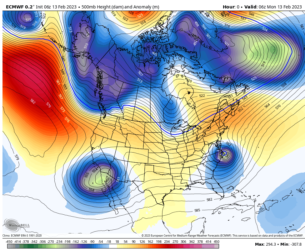
Two strong winter storms will impact New Mexico and surrounding areas today into Wednesday. Early this Monday morning the first winter storm (closed mid/upper-level low) to impact the area was centered over the northern Gulf of Baja, California. It is forecast to move east today and by around sunset should be located over central New Mexico. It will then pivot northeastward and by sunrise Tuesday morning will be located over far southeastern Colorado.
The second and stronger winter storm will drop southward out of the Great Basin and into northern Arizona as a closed mid/upper-level low Wednesday morning at sunrise. It will then swing eastward across central and northern New Mexico Wednesday. The closed low opens up as a shortwave trough of low pressure and exits the state on Thursday.
A Pacific cold front will sweep eastward across the state today and by sunset it will be moving east out of Southeastern New Mexico. A second and colder Pacific cold front will swing across the state and area on Wednesday.
A prolonged and significant high wind and blowing dust event is possible across southern New Mexico, the Sacramento, Capitan, and Guadalupe mountains, and parts of the eastern plains tonight through Wednesday.
Moderate to heavy snow is forecast for the northern mountains where Winter Storm Warnings are in effect. 6" to 12" will be possible today into Tuesday morning. Blowing snow will also occur in the mountains.
Moderate to heavy snow is forecast for the northern mountains where Winter Storm Warnings are in effect. 6" to 12" will be possible today into Tuesday morning. Blowing snow will also occur in the mountains.
ECMWF 500 MB (18,000' MSL) Forecasts.


Valid Today Through Wednesday Night.


Prolonged Significant High Wind Event.
A High Wind Warning remains in effect for Eddy County and the Guadalupe mountains of Eddy and Culberson Counties from 5 PM MST this Monday afternoon through 8 PM MST Tuesday evening.
Across the lower elevations of Eddy County west winds are forecast to increase tonight into Tuesday and become sustained at around 30 to 50 mph with gusts near 75 mph!
A High Wind Warning continues in effect for the Guadalupe mountains of Eddy and Cublerson Counties from 5 PM MST this Monday afternoon through 8 PM MST Tuesday evening. West winds will become sustained at 45 to 65 mph with gusts near 100 mph!
A High Wind Watch remains in effect for Chaves and Lincoln Counties, as well as for much of the eastern plains of New Mexico from late tonight through Tuesday afternoon. West winds becoming sustained at 35-45 mph with gusts to 65-70 mph are possible.
A High Wind Watch remains in effect for the southern Sacramento mountains from Noon MST today through 5 AM MST Tuesday. Southwest winds will become sustained at 35-50 mph with gusts near 70 mph.
A Wind Advisory remains in effect for Lea County and much of West Texas from 2 AM MST Tuesday morning through 5 PM MST Tuesday afternoon. West winds sustained at 25-35 mph with gusts to 50 mph are expected.
A Wind Advisory remains in effect from Noon MST today through 8 PM MST this evening for all of southern New Mexico. West winds sustained at 25-35 mph with gusts to 50 mph are expected.
Note: The El Paso/Santa Teresa National Weather Service Office currently (as 4 AM MST this Monday morning) has west winds sustained at 44-49 mph with gusts to 80 mph possible Wednesday morning in the Cloudcroft area!
These high wind gusts (especially 70 mph and higher) will be capable of causing damages to: roofs, small outbuildings, barns, sheds, trees, power lines, and other utility lines. Some west facing windows may be blown out with gusts over 70 mph. Downed power lines may start wildfires. Although it is somewhat unusual for us to have high winds at night it is not unheard of locally.
Areas of widespread blowing dust will develop tonight into Tuesday with the worst conditions expected on Tuesday. Blinding dust storms occurring during the strongest winds will severely limit the visibility in dust prone locations. This will be especially true in the following locations: freshly plowed or exposed farmlands, fields, lots, and highway construction sites. Sudden drops in the visibility down to zero with little to no advanced warning may occur. Please remember that Southeastern New Mexico and nearby areas have a long history of vehicle pileup's during these blinding dust storms with injuries and fatalities in some cases in past years.


Valid Today Through 5 AM MST Thursday Morning.


Moderate To Heavy Snowfall In The Sac's.
Our first winter storm is forecast to drop 1" to 3" of snow in the Ruidoso area today through Wednesday. In the Cloudcroft area 2" to 4" are currently forecast to fall by Wednesday. Locally heavier snowfall totals at the higher elevations of 6" to 8" could fall by Wednesday evening. Areas of blowing and drifting snow, moderate to locally heavy snowfall, and icy and snow packed roads will create travel problems at times today through Thursday morning.
Wind chill values across the higher elevations (above 8,000') of the Sacramento mountains will range from near zero to -11 tonight into Wednesday.


Low level southeasterly upslope flow from the Gulf of Mexico ahead of the approaching winter storm from the west will increase surface moisture across parts of West Texas and southeastern New Mexico this afternoon into Tuesday morning. A few isolated thunderstorms cannot be ruled out over the state and especially over parts of the Permian Basin of West Texas. Scattered rain showers at the lower elevations this afternoon into Tuesday morning may deposit up to a tenth of an inch of rainfall in a few local areas across Southeastern New Mexico.
There Are None So Blind As Those Who "Will - Not" To See...107.


Comments
Post a Comment
Your comments, questions, and feedback on this post/web page are welcome.