


Spring-Like Weather Today & Monday Back To Winter Tuesday.

Dark Canyon Moonrise.

Valid At 5 PM MST Monday.

Spring-Like Weather Today & Monday Back To Winter Tuesday.
As we countdown the last days of the meteorological winter mother nature wants to jump in and give us a couple of days of spring-like weather. As of 3:30 PM MST this beautiful Sunday afternoon high temps across the local have reached the mid to upper 70's across the southeastern plains and southern New Mexico, as well as over parts of West Texas. While reporting stations in the Sacramento mountains are reporting highs mostly in the 50's and 60's.
Yet another mid/upper-level short wave trough of low pressure located west of Portland, Oregon this afternoon will swing southeast into the Four Corners by around sunset Monday. By sunset Tuesday it is forecast to be centered near El Paso. Then it pulls off to the northeast and should be centered over northern Texas by sunset Wednesday.
At the surface a Pacific cold front will swing southeastward across New Mexico Monday. By sunset it should be moving eastward out of the southeastern plains.

At 11 AM MST Sunday, February 5, 2023.
ECMWF 500 MB (18,000' MSL) Forecast.

Valid At 5 PM MST Monday.

Warm & Windy Monday.
Monday will be almost as warm as today across the local area with high temps just a few degrees cooler in most places. Colder air moves in behind the cold front Monday night and Tuesday.
Highs Tuesday across the southeastern plains are forecast to range from near 50 to the low 50's. Highs in the mountains will range from the mid to upper 30's in the Ruidoso area to the upper 20's to near 32 in the Cloudcroft area.
Monday.

Tuesday.

Breezy To Windy Monday.
West winds are forecast to become sustained at 35 to 45 mph with gusts near 60 mph across the Guadalupe mountains Monday morning into Monday evening. A High Wind Warning is in effect.
A Wind Advisory is in effect for parts of southern and southwestern New Mexico as well as Otero County on Monday. West winds sustained at around 25 to 35 mph with gusts near 50 mph are forecast. West winds will gust up to around 30 to 40 mph Monday across the southeastern plains.

Chance For Rain & Snow Showers.
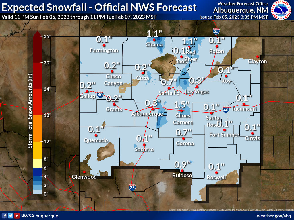
A mix of lowland/valley light rain and or light snow showers will be possible Tuesday into Tuesday night across the southeastern plains. A chance for a mix of light rain and light snow showers will occur across southern New Mexico with snow levels dropping down to around 4,000' Tuesday. Snow showers are possible in the mountains Tuesday into Tuesday night. As of this Sunday afternoon significant rainfall and snowfall does not appear likely. Snowfall totals may however get up into the 1" to 3" range at the higher elevations of the Sacramento and Capitan mountains.

Valid At 5 AM MST Wednesday.
NWS NDFD Forecast Snowfall Totals.

There Are None So Blind As Those Who "Will - Not" To See...107.


Comments
Post a Comment
Your comments, questions, and feedback on this post/web page are welcome.