Here We Go Again - Another Widespread High Wind/Blowing Dust Event!
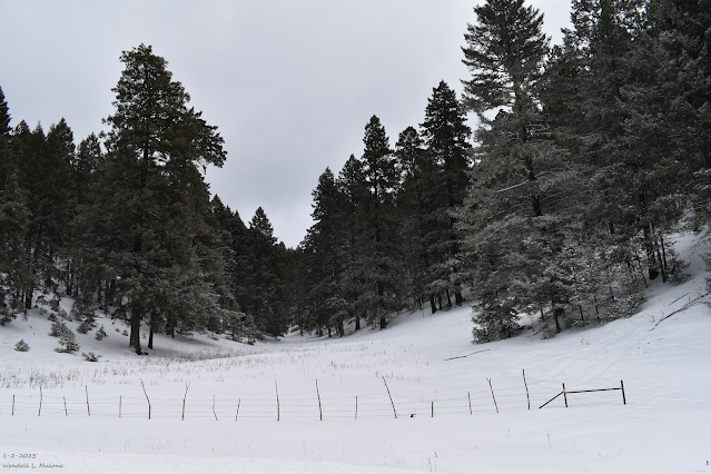
January 2, 2023.
Near Sunspot, New Mexico.
Yet Another Widespread High Wind/Blowing Dust Event Sunday!
Here we go again. A powerful Pacific winter storm is absolutely hammering southern California this Saturday morning. To put the strength of this storm into perspective consider this. La Crescenta-Montrose, California which is located north of Glendale, and east of Los Angeles recorded 8.05" of rainfall over the past 24 hours (CoCoRaHS Station) and 9.23" over the past 48-hours. And they are not done yet. The Mount Shasta CoCoRaHS Station has already measured 32.0" of snowfall the past two days. Four day snowfall totals at the Mountain High location are 81.0". Forecasts for parts of the southern Sierra Nevada are calling for snowfall totals of five to eight feet from this storm along with wind gusts up to 87 mph! Another 4" to 10" of rainfall is forecast for the foothills locations.
By the time this potent winter storm arrives in New Mexico tomorrow (Sunday) it will have spent most of its associated rainfall and snowfall. 1" - 3" of new snowfall will be possible over the southwestern, western, and northern mountains of the state. Current forecasts (as of Saturday morning) are calling for an inch or less across the Sacramento mountains.
Late tonight areas of low clouds, fog, and a few light rain showers will develop over portions of the Southeastern Plains. These will burn off quickly Sunday morning as strong southwesterly downsloping winds crank ahead ahead of the inbound winter storm from the west.
Late tonight areas of low clouds, fog, and a few light rain showers will develop over portions of the Southeastern Plains. These will burn off quickly Sunday morning as strong southwesterly downsloping winds crank ahead ahead of the inbound winter storm from the west.
Once again the main weather event will be high winds and widespread blowing dust over most of the state and nearby areas.
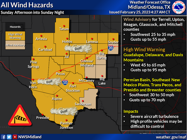
Correction - Across the southern Sacramento mountains: A High Wind Warning is in effect from 9 AM MST Sunday through Midnight MST Sunday night. West winds will become sustained at 45 - 55 mph with gusts to 85 mph! Power outages are possible. Blowing dust may reduce the visibility and affect travel through the mountains.
For the northern Sacramento mountains: A High Wind Watch is in effect from Sunday morning through late Sunday night. West winds will become sustained at 40-50 mph with gusts near 65-75 mph! Power outages are possible. Brief periods of blowing snow may create reduced visibility which may affect travel through the mountains. Blowing dust may also reduce the visibility and affect travel through the mountains.
For the northern Sacramento mountains: A High Wind Watch is in effect from Sunday morning through late Sunday night. West winds will become sustained at 40-50 mph with gusts near 65-75 mph! Power outages are possible. Brief periods of blowing snow may create reduced visibility which may affect travel through the mountains. Blowing dust may also reduce the visibility and affect travel through the mountains.
Across the Chaves County Plains A High Wind Watch is in effect from Sunday morning through late Sunday night. West winds will become sustained at 40-50 mph with gusts near 65-75 mph! Power outages are possible. Damage form the higher wind gusts may occur.
Across Eddy and Lea Counties: A High Wind Warning is in effect from 10 AM MST Sunday through 11 PM MST Sunday night. Southwesterly winds will become sustained at 35 - 55 mph with gusts to 70 mph! Damage form the higher wind gusts may occur.
Guadalupe Mountains of Eddy/Culberson Counties: A High Wind Warning remains in effect until 10 AM MST Sunday through 9 PM MST Monday. West winds sustained at 45 - 65 mph with gusts to near 95 mph are expected!. Damages from the winds may occur. Blowing dust may also reduce the visibility and affect travel through the mountains
High winds across parts of the state and locally may down trees, power lines, and power poles which may cause power outages in some locations. Other utility and cable lines may also be downed. Wind damage to homes, roofs, shingles, fences, sheds, barns, and other outbuildings are possible in many areas. Some west facing windows could blow out in gusts above 70 mph. Vehicles on north/south oriented highways may be blown over or blown off roads and highways. Especially high profile vehicles such as semi trucks, and camper trailers, and vans.
Widespread blowing dust is expected over much of the lower elevations of the state Sunday. Blowing dust locally may be more widespread with the more southern location of the core of the jet stream wind speed maximum overhead.
Many areas could see the visibility drop down to 1/2 of a mile. Dust prone locations such as freshly plowed, cultivated, exposed or open farmlands and fields, lots, and highway construction sites (oil field areas) will experience sudden drops in the visibility down to zero with little to no advanced warning. Travel upon the states highways and roadways in these areas will be dangerous if not impossible in some locations at times.
Life threatening conditions may exist due to the brownout conditions. Remember that southeastern New Mexico has a long history of multivehicle accidents with fatalities and injuries during these blinding dust storms.
Although not likely any wildfire (pray they don't) that could possibly develop (from downed power lines and other sources) could potentially add to the dangerous travel conditions especially if they break out near highways or roadways. Dense smoke could combine with the blowing dust to add to the hazardous conditions.
GFS 500 MB (18,000') Forecast.
NWS NDFD Rainfall Forecast.
NWS NDFD Snowfall Forecast.
As the meteorological winter comes to a close Wednesday (March 1st) and the meteorological spring beings, a round of severe thunderstorms will break out across parts of the West Texas northeastward into Kansas Sunday afternoon and evening. Locally parts of the far eastern Permian Basin, and areas north and east of the Lubbock area will get in on the action also. The dryline will be located over West Texas Sunday afternoon and as it mixes eastward the Pacific cold front approaching from the west will overtake it late Sunday afternoon and evening. Large hail and damaging thunderstorm wind gusts will be the primary severe weather threats. A squall line is forecast to develop and a few isolated tornadoes may also occur.
There Are None So Blind As Those Who "Will - Not" To See...107.


Comments
Post a Comment
Your comments, questions, and feedback on this post/web page are welcome.