

Storm Summary - Sunday, March 19, 2023.

March 15, 2023.
Lubbock, Texas.
Altocumulus Standing Lenticular Clouds (ACSL).
Blog Updated At 6:42 PM MDT Sunday, March 19, 2023.
The Haves And The Have Nots.
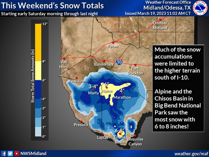
Our series of winter storms over the past week have left behind some very impressive rainfall and snowfall totals. Especially for March which is normally is our driest month of the year. Many areas of the state picked up a quarter to a half of an inch of rain while the southeastern plains received zip, zada, nada! Snowfall totals across the northern mountains have exceeded 18" to 24" in a few spots in the Sangre de Cristo mountains.
Yet another winter storm will impact the state Monday through Wednesday with heavy northern mountain snows and moderate rains across portions of the state's valley locations. And then another colder storm Thursday with continued unsettled weather conditions into next weekend. Another high wind event looks likely across the Guadalupe, Sacramento, and Capitan mountains, and the southeastern plains Tuesday and Wednesday. Off and on periods of rain and snow returns once again in the forecasts for the Sacramento and Guadalupe mountains as well Monday through Thursday.
Some of the heavier storm totals include the following.
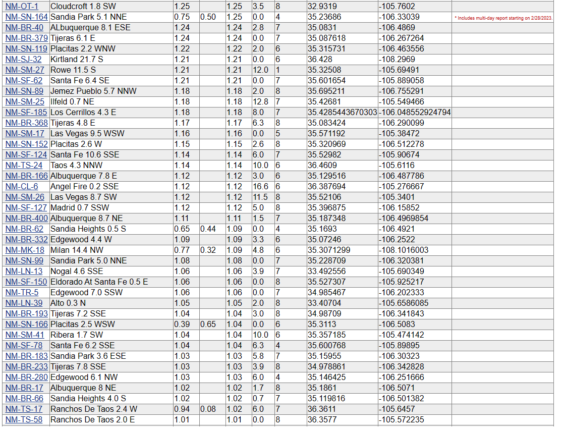
Sandia Park CoCoRaHS Station 0.5 Miles S 2.79"
Rowe CoCoRaHS Station 2.7 Miles NNW 2.53"
Cedar Crest CoCoRaHS Station 0.5 Miles NNW 2.34"
Cloudcroft CoCoRaHS Station 2.3 Miles S 1.42"
Cloudcroft CoCoRaHS Station 0.4 Miles ESE 1.34"
Alto CoCoRaHS Station 7.4 Miles W 1.34"
Smokey Bear Raws 1 Mile NW Of Ruidoso 1.20"
The Cloudcroft National Weather Service Climate Co-Op Station measured 6.1" of snowfall out of this latest series of storms bringing their seasonal to-date total to 63.2". Ski Apache picked up 12.0" over the past week bringing their seasonal total to around 80.0".
(As Of Saturday, March 18, 2023).


(As Of 9 AM MDT Saturday, March 18, 2023).

(As Of 6 AM MDT Saturday, March 18, 2023).


(As Of Saturday, March 18, 2023).

(Monday, March 13th - Friday, March 17th).


New Mexico 7-Day CoCoRaHS Rainfall Totals.


New Mexico CoCoRaHS 7-Day Snowfall Totals.


There Are None So Blind As Those Who "Will - Not" To See...107.


Comments
Post a Comment
Your comments, questions, and feedback on this post/web page are welcome.