


Winter Say's To Spring - Here Hold My Beer & Watch This!

Yucca Sunset.
March 12, 2023. Carlsbad, New Mexico.

Valid Wednesday Through Next Monday.
NWS NBM Total Snowfall Forecast.
NWS NBM Total Snowfall Forecast.


Valid 6 PM MDT Thursday Through 6 PM MDT Saturday.
Winter Say's To Spring - Here Hold My Beer & Watch This!
A parade of storms is forecast to impact the area Wednesday through the first of next week. A strong back door cold front will slide southward down the eastern plains and into Southeastern New Mexico Thursday afternoon bringing an end to our run of warm spring temps. A series upper level disturbances will cross the region during this time frame also. These will aide in producing rain and snow statewide.
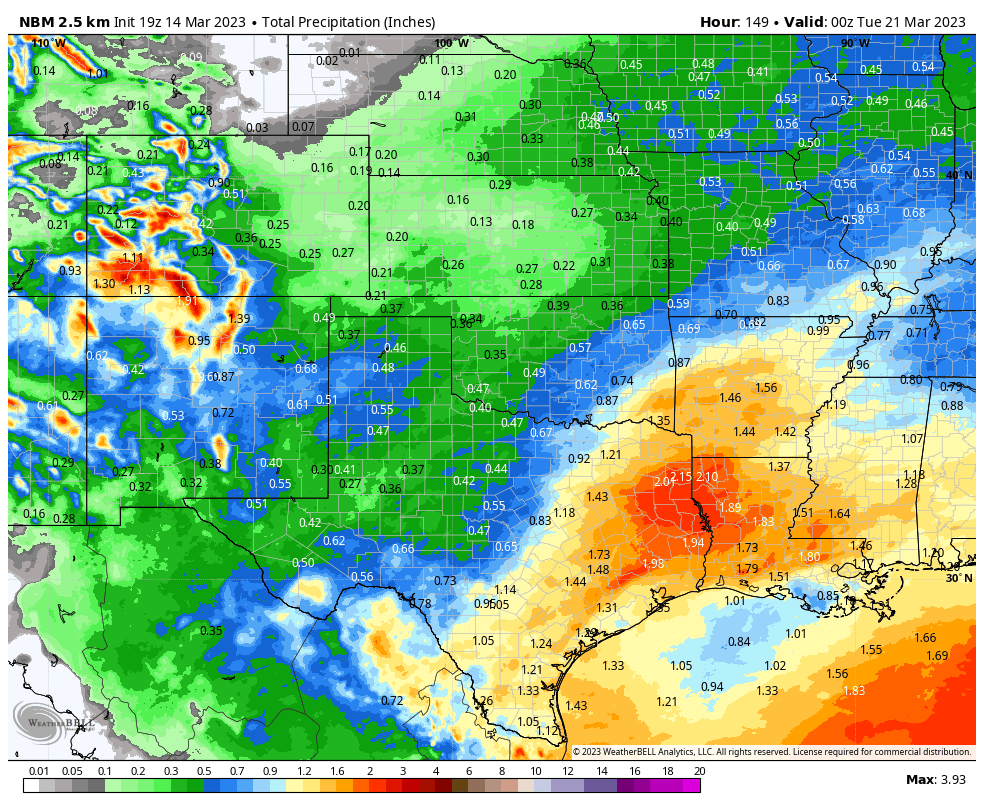
For a change I have some good news to report. Although Wednesday and Thursday will be windy and dusty in places overall the period Thursday through the first of next week stands a decent chance of being wet areawide. The Sacramento mountains look to pick up some decent snowfall totals by the first of next week. Rainfall totals across the Southeastern Plains could be as high as a half of an inch or more. Some areas of the state could see precipitation totals of half of an inch to over an inch, with over an inch in a few areas. If we keep this up we are headed for a wet and green spring instead of a dry and brown spring.
A Winter Storm Watch is in effect for the northern mountains from Wednesday evening through late Thursday night. Snowfall totals of 8" to 12" with higher amounts above 10,000' are forecast. Additional moderate to heavy snowfall is forecast for these areas and other areas of the state Thursday night into the weekend.
A Winter Storm Watch is in effect for the northern mountains from Wednesday evening through late Thursday night. Snowfall totals of 8" to 12" with higher amounts above 10,000' are forecast. Additional moderate to heavy snowfall is forecast for these areas and other areas of the state Thursday night into the weekend.
This is a first look at our upcoming weather changes so be prepared, and expect to see additional changes in our local forecasts over the next five or six days.
Southeastern Plains Forecasts.
Wednesday: Our first storm produces breezy to windy weather Wednesday into Thursday. Southwest winds will increase to sustained speeds of 15-25 mph with gusts near 30-40 mph. Our high temps will climb up close to 80º.
Thursday: Windy with patchy areas of blowing dust. Our afternoon highs will range from near 70º to the low 70's. West winds becoming sustained at around 20-30 mph with gusts to 40-50 mph. A few widely scattered light rain showers are also possible.
Thursday Night: Scattered light rain showers and perhaps a few light snow showers will mix in with the rain showers. Our chances for measurable precipitation are 30%. Lows in the low 30's.
Friday: Scattered light rain and light snow showers. Chances for measurable precipitation are 20%. Highs in the upper 40's to near 50º.
Saturday and Sunday: Scattered light rain and light snow showers. Chances for measurable precipitation are 20% to 30%. High temps will range from near 50º on Saturday to the mid-upper 40's on Sunday.
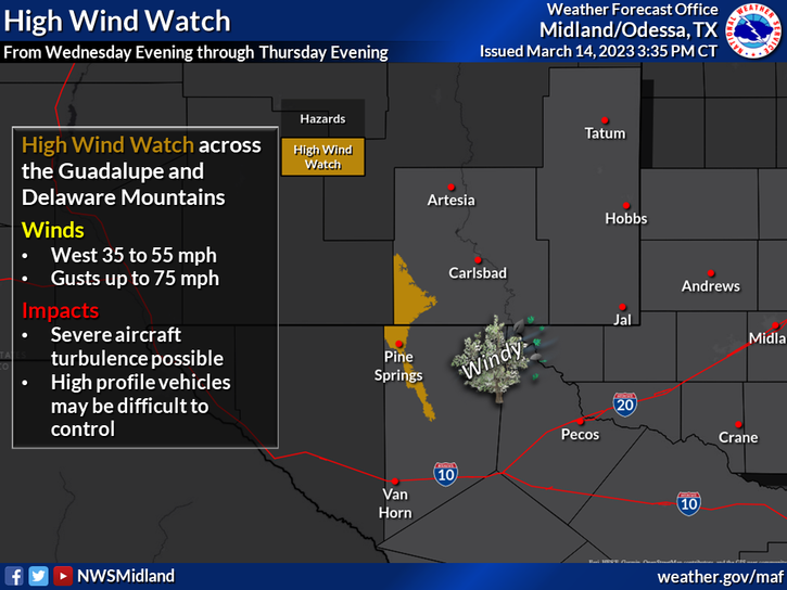
A High Wind Watch is in effect for the Guadalupe mountains of Eddy and Culberson Counties Wednesday evening through Thursday evening. West winds will become sustained at 35-55 mph with gusts near 75 mph.
At this time (Tuesday night) snowfall accumulations for the southeastern plains are forecast to be less than an inch Thursday into Friday morning. Accumulating snow is possible across the Southeastern Plains Saturday into Monday. It's possible that some areas could see 1" to 3". Our overnight low temperatures will drop down to near or slightly below freezing Thursday night into the first of next week.
Sacramento Mountains Forecasts.
Wednesday: Storm number one produces windy weather. Southwest winds will increase to sustained speeds of 25-40 mph with gusts near 50-70 mph. High temps in the Ruidoso area will climb up to near 60º. High temps in the Cloudcroft area will be near 50º.
Wednesday Night: Windy with west winds sustained at 30 to 35 mph with gusts near 50-60 mph. Ruidoso has a 50% chance for rain showers and a low in the upper 30's. Wednesday night. Cloudcroft has a 60% chance for rain and snow showers with a low near freezing. No significant accumulations of snow are forecast.
Wednesday Night: Windy with west winds sustained at 30 to 35 mph with gusts near 50-60 mph. Ruidoso has a 50% chance for rain showers and a low in the upper 30's. Wednesday night. Cloudcroft has a 60% chance for rain and snow showers with a low near freezing. No significant accumulations of snow are forecast.
Thursday: Windy with west winds sustained at around 25-30 mph gusting to near 40 mph. The Ruidoso area has a 60% chance for rain showers and a high in the low-mid 50's. Cloudcroft has a 60% chance for rain and snow showers with a high in the low 40's.
Thursday Night: Cold with scattered snow showers. Both Ruidoso and Cloudcroft have a 50% chance for snow with a low near 20º. West winds in Cloudcroft will gust up to near 40 mph.
Friday: Scattered snow showers. The Ruidoso area has a 40% for snow showers with a high near 40º. Cloudcroft has a 50% chance for snow with a high near 30º.
Saturday and Sunday: Snow showers likely in the Ruidoso and Cloudcroft areas. Chances for snow Saturday through Sunday are in the 50% to 70% range. Highs in the Ruidoso area Saturday will be near 40º and Sunday the low 40º. Highs in the Cloudcroft area Saturday will be near 30º and the low 30's on Sunday.
Snowfall accumulations in the Ruidoso and Cloudcroft areas are forecast to be 1" to 3" Wednesday night through Friday. With the heaviest snowfall above 8,500'. Snowfall accumulations of Saturday into Sunday night are currently forecast to be in the 4" to 6" range. Additional snowfall is forecast the beginning of next week.
There Are None So Blind As Those Who "Will - Not" To See...107.


Comments
Post a Comment
Your comments, questions, and feedback on this post/web page are welcome.