Fall Cold Front To Bring A Much Need & Welcomed Change Monday Into Next Week.
Sierra Blanca Peak.
Looking West From Windy Point Vista.
Fall Knocks On Our Front Door Next Week.
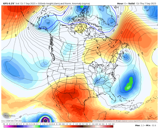
Valid At 6 AM MDT Thursday, Sept 7, 2023.
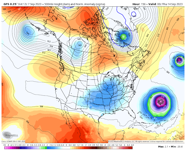
GFS 500 Millibar (18,000' MSL) Forecast.
Valid At 6 PM MDT Wednesday, Sept 13, 2023.
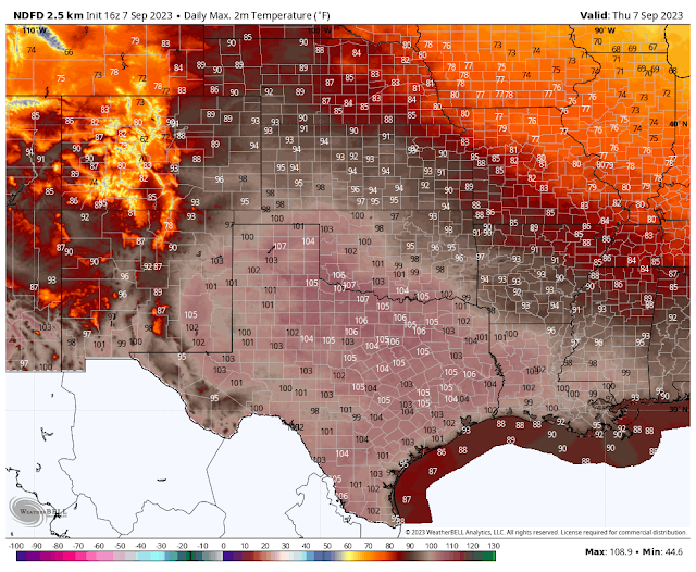
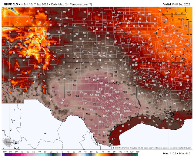
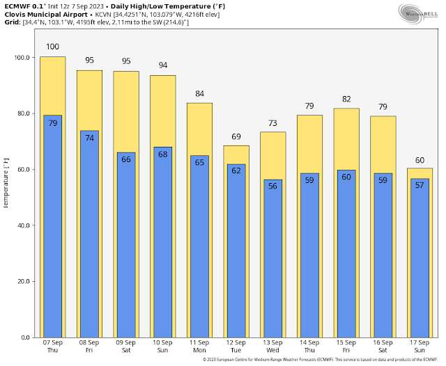
Today.
Friday.
Saturday.
Sunday.
Monday.
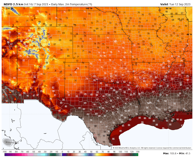
Tuesday.
Wednesday.
Tuesday Morning.
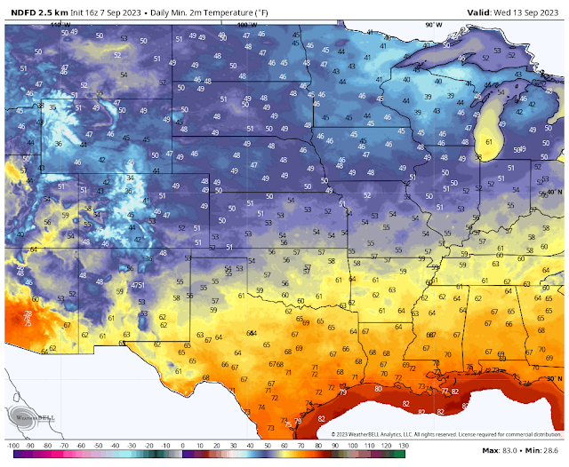
Wednesday Morning.
Changes Taking Place In The Upper Air Pattern.
As we move towards the middle of the month we are seeing changes taking shape in the upper air pattern over North America. All summer long a persistent, and unusually strong mid-upper level ridge of high pressure, has dominated our weather here in New Mexico and nearby areas. This ridge has wobbled around the region and at times allowed surges of monsoonal moisture to work into the state from northern Mexico. But overall our annual summer monsoon has been on the weak side this year.
This morning the center of the strong mid-upper level ridge of high pressure was centered over northern Mexico and southern New Mexico. A series of mid-level short wave troughs of low pressure will dig southeast into the northern plains of the U.S. late this weekend into next week. These troughs of low pressure will eventually weaken, and force the mid-upper level ridge of high pressure to move off to the south and southwest of New Mexico.
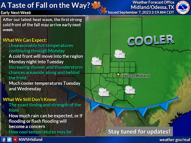
Strong Fall Cold Front Headed South Towards SE NM Late Monday.
As one of these short wave troughs deepens over the Great Lakes Region late this weekend into the first of next week, a strong cold front will surge south into the northeastern and eastern plains of New Mexico Sunday night into Monday.
This strong cold front will then work its way southward and west into southeastern New Mexico, and the rest of the state Monday afternoon into Tuesday. A much needed and welcomed change to cooler temperatures will accompany the frontal passage. Everybody I know is sick and tired of this torrid summer we have endured. It's not the hottest summer on record for us but it will likely go down in the top ten I think.
Much Cooler Next Week.
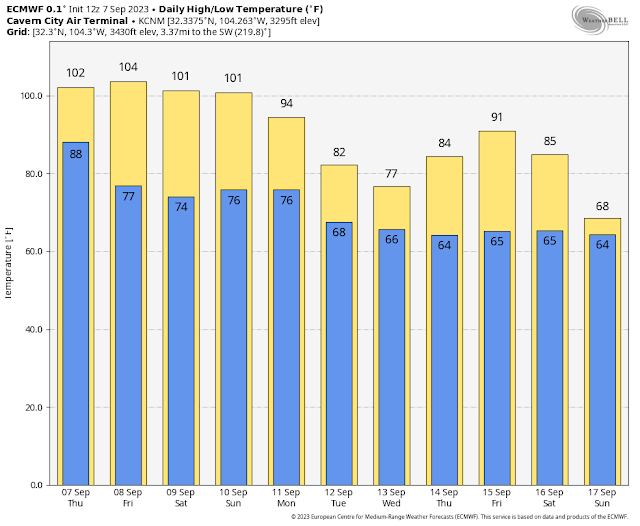
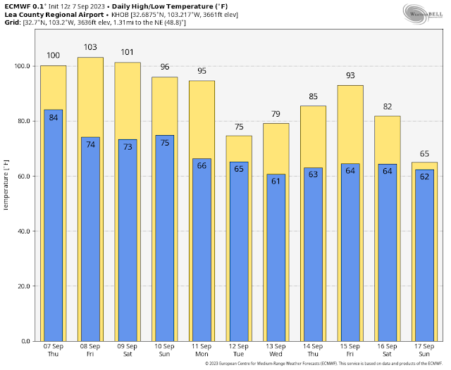
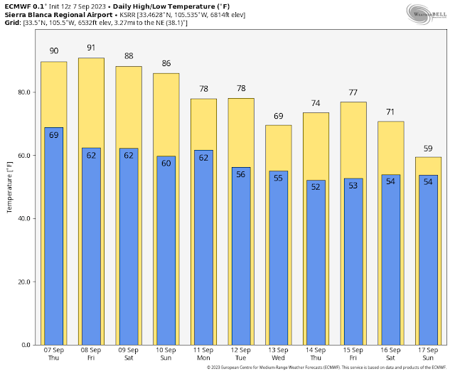
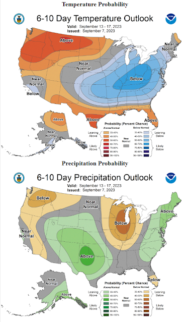
After seeing record setting daily and possibly monthly high temperatures today and Friday (near 105) next week is looking much cooler. Current forecasts have most of southeastern New Mexico only in the 80's next Tuesday and Wednesday. Maybe even in the 70's in some areas. The rest of next week looks seasonably cool also with highs mostly in the 70's and 80's across the eastern and southeastern plains.
Highs across the mountains will also cool down into the 60's and 70's next Tuesday and Wednesday and possibly through the rest of the week.
T-Storms forecast To Return With Much Needed & Welcomed Rainfall.
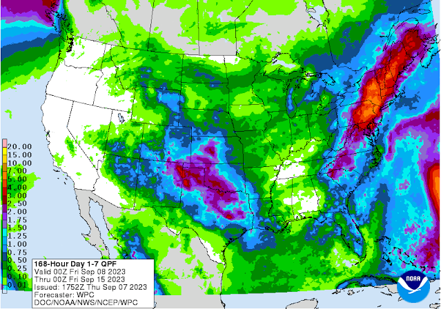
Low level easterly and southeasterly upslope flow will import low-level moisture into the area along and behind the cold front Monday into the middle of next week. It's still too early to try and pinpoint who will get the heaviest rainfall and how much but overall the forecast model trends are optimistic at this point that many in New Mexico and nearby areas are going to get wet from this weekend into next week.
A few hit and miss thunderstorms will occur across the Sacramento mountains today and Friday. Scattered thunderstorms should break out across the eastern and southeastern plains Sunday ahead of the approaching southward moving cold front. The Sacramento, Capitan, and Guadalupe mountains will see thunderstorm activity begin to increase this weekend also.
We will need to watch to see if enough instability is available to fire off severe thunderstorms along and behind the cold front as it moves south down the eastern side of the state Sunday into Monday night.
Localized heavy rainfall along with localized heavy rainfall appears possible. As has been the case all summer of particular concern will be the burn scar areas in the mountains which are highly susceptible to flash flooding.
September Is A transition Month Weather-wise.
September is a month of transition with New Mexico's weather. Fall cold fronts get stronger and colder with time as the jet stream strengthens and occasionally sags south into the state. Severe thunderstorms are no stranger to the state in September either. In fact the eastern and southeastern plains often see a second severe weather season (Sept - Oct) during this time. Nor is it uncommon for the states higher peaks to experience their first snowfall of the season in September. Many of the states higher mountain valleys experience their first freeze of the season in September.
For details concerning the New Mexico State Fair's historical weather and climatology please visit this link courtesy of the Albuquerque National Weather Service Office.
See the latest Drought Information Statement for New Mexico via this link.
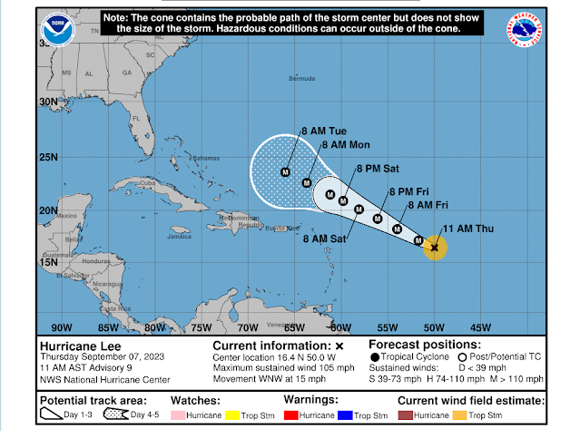
There is the real possibility that powerful Hurricane Lee which is undergoing rapid intensification, and is forecast to continue to do so into Saturday, will go down in the record books as one of the strongest hurricanes seen in the Atlantic Basin in years. So far Lee is out pacing the forecast models, and as noted in the NHC's forecast discussion above, he may even have sustained winds of over 170 mph with gusts over 200 mph over the next couple of days.
There Are None So Blind As Those Who "Will - Not" To See...107.















Comments
Post a Comment
Your comments, questions, and feedback on this post/web page are welcome.