Hello Fall Weather - Glad To see Ya Show Up!
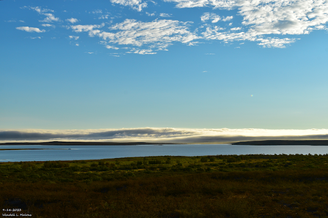
Early Morning Fog Bank.
Brantley Lake Between Artesia & Carlsbad.
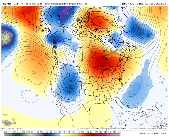
ECMWF 500 Millibar (18,000' MSL) Forecast.
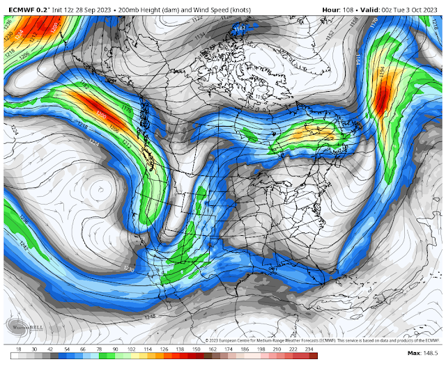
ECMWF 500 Millibar (18,000' MSL) Forecast.
Valid At 6 AM MDT Tuesday, October 3, 2023.
Valid At 6 PM MDT Tuesday, October 3, 2023.
Valid At 6 AM Tuesday, Oct 3, 2023.
ECMWF Storm Total Snowfall Forecast.
Valid At 6 AM Tuesday, Oct 3, 2023.
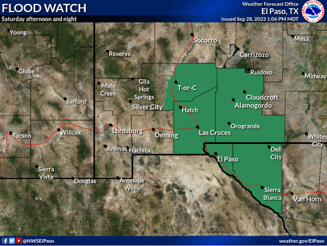
NWS El Paso/Santa Teresa Flood Watch.
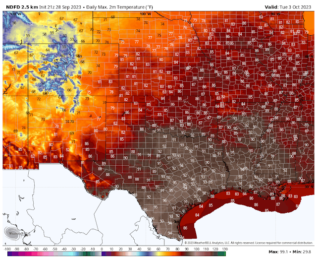
Tuesday, October 3, 203.
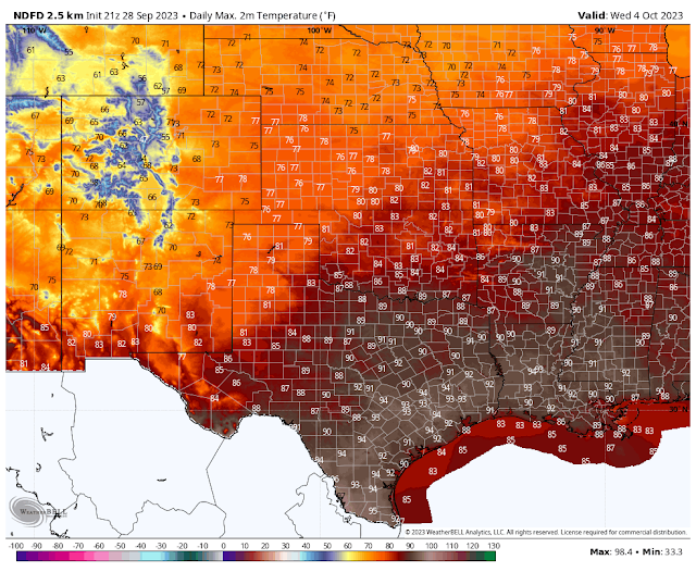
Wednesday, October 4, 2023.
Big Changes In Our Weather Starting This Weekend.
Summertime conditions continue to stubbornly hang on but this shall end soon. A strong mid-upper level low diving southward out of the Gulf of Alaska and into the Pacific Northwest this afternoon will bring changes to our weather starting tomorrow. A split flow in the jet stream will help to strengthen this mid-upper level storm into the first of next week.
By Saturday around sunset this strong mid-upper level low is forecast to be located over central California, and by Tuesday morning around sunrise it should be moving into the Four Corners Region.
The seasons first strong Pacific cold front is forecast to enter the Four Corners Region on Monday then progress eastward across the state into Tuesday. The dryline will sharpen up over eastern New Mexico this weekend and persisting into early next week.
Low-level and mid-level moisture will get drawn northward into the state starting tomorrow and continuing through the weekend into the first of next week.
As the upper level storm approaches showers and thunderstorms should ramp up along the states central mountain chain eastward starting Friday afternoon. The weekend should get fairly busy with thunderstorm activity especially over and east of the central mountain chain out onto the eastern and southeastern plains. A few severe thunderstorms will be possible this weekend into the first of the week.
A Flood Watch has been issued for parts of southern New Mexico and far West Texas for Saturday into Saturday evening. This includes the El Paso, Las Cruces, Alamogordo, and Tulorosa areas. Also included is all of the southern Sacramento mountains including the Timberon, Sunspot, Cloudcroft, Silver Lake, Mescalero, High Rolls/Mountain Park, 16-Springs Canyon, Mayhill, Sacramento/Weed, and Pinion areas. T-storms will produce locally heavy rainfall especially backbuilding and or training thunderstorms. Meaning multiple thunderstorms developing over the same location and producing multiple rounds of heavy rainfall on Saturday.
Widely scattered thunderstorms will be possible across the southeastern plains Friday afternoon and evening. This activity is expected to ramp up this weekend. A few thunderstorms may become severe and be capable of producing large hail and damaging winds. Scattered thunderstorms are forecast to continue Monday and Tuesday ahead of the approaching upper level storm and Pacific cold front.
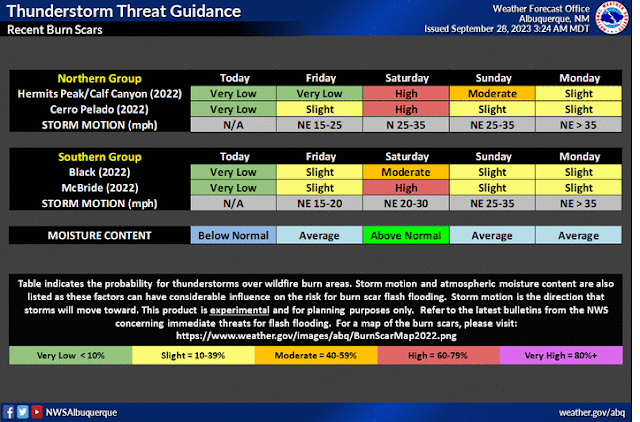
Storm total rainfall amounts may be in the 1" to 3" range along and east of the mountains by Tuesday with some spots possibly seeing higher totals especially over and near the mountains. Localized flash flooding will be a concern this weekend into the first of next week. Practically over and near the mountains and the burn scar areas.
High mountain snow showers are possible across the higher peaks of the northern mountains of New Mexico, generally above 10,000', this weekend into the first of next week.
High temperatures will continue above normal into the weekend with the mid 90's forecast for Friday across the southeastern plains. Our highs will cool down into the upper 80's to near 90 for Saturday and the mid-upper 80's Sunday into Tuesday. By Wednesday we should only see highs near 80.
For the Sacramento mountains the upper 70's in the Ruidoso area on Friday, the mid 70's on Saturday, and the low 70's Sunday into Tuesday. And the upper 60's Tuesday and Wednesday. For the Cloudcroft area the upper 60's on Friday with the mid 60's on Saturday. Sunday into Monday the low 60's and the upper 50's for Tuesday and Wednesday.
There Are None So Blind As Those Who "Will - Not" To See...107.






Comments
Post a Comment
Your comments, questions, and feedback on this post/web page are welcome.