Another Round Of Severe T-Storms This Afternoon & Evening!
Roswell, New Mexico.
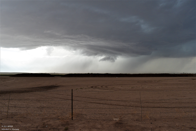
Truck Bypass Looking Northwest.
NWS Midland Severe Weather Outlook Today.
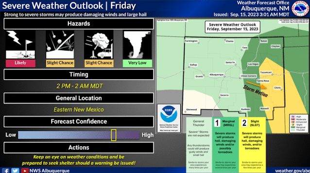
NWS Albuquerque Severe Weather Outlook Today.
NWS Albuquerque Burn Scar Matrix Forecast.
Weather Prediction Center (WPC) 7-Day Total Rainfall Forecast.
Another Round Of Severe T-Storms Today.
Finally our unusually strong and persistent mid-level ridge of high pressure has been pretty much wiped out across the region this morning. Zonal flow has taken over at the mid-levels with embedded disturbances zipping across the area from time to time. These will help destabilize the atmosphere later this afternoon into tonight aiding in the development of scattered t-storms across parts of the state and local area.
At the surface a southward moving backdoor cold front will sag down the eastern plains and into southeastern New Mexico this afternoon into Saturday morning. This front will provide additional low-level upslope flow/moisture and convergence along it. This will aide in the development in thunderstorms.
After seeing our afternoon high temps across the southeastern plains climb up into the upper 80's to near 90 this afternoon, cooler air behind the front will only allow us to get up to around 80 or so on Saturday and the mid 80's on Sunday. The low to mid 90's return Monday and Tuesday.
After seeing our afternoon high temps across the southeastern plains climb up into the upper 80's to near 90 this afternoon, cooler air behind the front will only allow us to get up to around 80 or so on Saturday and the mid 80's on Sunday. The low to mid 90's return Monday and Tuesday.
Across the Sacramento mountains high temps today are forecast to range from the low to mid 60's to the low to mid 70's. Highs on Saturday will only be in the low to upper 60's. Scattered afternoon and evening t-storms are forecast today into the weekend.
Scattered t-storms are forecast to develop over mainly the eastern one half of the state this afternoon continuing into tonight. Some of these will become severe especially over the eastern and southeastern plains eastward into parts of West Texas. Large hail and damaging thunderstorm wind gusts in excess of 58 mph will be possible.
Locally heavy rainfall will occur with the stronger storms that may cause localized flash flooding. Frequent lightning will also accompany any thunderstorm. Some of the heavier storm total rainfall amounts may be in the 1" to 2" range.
A few supercell thunderstorms may also develop. These rotating t-storms may produce a few tornadoes.
Our chances of measurable rainfall across the southeastern plains range from 20% - 30% today, increasing to 50% - 70% tonight. Dropping down into the 20% to 40% range Saturday and Sunday.
(As Of 8 AM MDT Friday, Sept 15, 2023).
(As Of 8 AM MDT Friday, Sept 15, 2023).
(As Of 8 AM MDT Friday, Sept 15, 2023).
(As Of 8 AM MDT Friday, Sept 15, 2023).
Public Information Statement
National Weather Service Albuquerque NM
952 AM MDT Fri Sep 15 2023

...HAIL REPORTS...

Location                     Size      Time/Date

...New Mexico...

...San Miguel County...
San Geronimo                 0.75 in   1151 AM 09/14
3 NW Romeroville             0.50 in   1144 AM 09/14

...HIGHEST WIND REPORTS...

Location                     Speed     Time/Date

...New Mexico...

...Bernalillo County...
Albuquerque Intl Sunport     43 MPH    0638 PM 09/14

...Chaves County...
Dunken 2 NE (Dunken)         44 MPH    0636 PM 09/14

...Roosevelt County...
Dora 2 SW                    41 MPH    1118 PM 09/14

...Socorro County...
Mine (WSMR)                  65 MPH    0400 PM 09/14
Contreras 1 ESE (Sevilleta)  59 MPH    0511 PM 09/14
Little Burro (WSMR)          50 MPH    0355 PM 09/14
Zumwalt Track (WSMR)         44 MPH    0315 PM 09/14
Stallion WIT (WSMR)          42 MPH    0330 PM 09/14
Sulf (WSMR)                  41 MPH    0325 PM 09/14

...PRECIPITATION REPORTS...

Location                     Amount    Time/Date

...New Mexico...

...Bernalillo County...
Ponderosa 2 W                0.29 in   0700 AM 09/15
Ponderosa 2 WNW              0.24 in   0700 AM 09/15
Albuquerque 8.7 SE           0.23 in   0700 AM 09/15
Ponderosa 2 W                0.23 in   0939 AM 09/15
Ponderosa 1 WSW              0.22 in   0700 AM 09/15

...Catron County...
Reserve 1 WSW                0.62 in   0908 AM 09/15
Reserve 1 W                  0.55 in   0915 AM 09/15
Beaverhead                   0.41 in   0908 AM 09/15

...Chaves County...
Roswell 5.1 N                0.51 in   0800 AM 09/15
Roswell 4.3 N                0.49 in   0700 AM 09/15
Roswell 5.2 N                0.42 in   0800 AM 09/15
Roswell 3.4 NNE              0.25 in   0700 AM 09/15

...Colfax County...
Raton Crews Airport          0.31 in   0853 AM 09/15
Angel Fire 4.1 NNW           0.24 in   0700 AM 09/15

...Curry County...
Ned Houk State Park          1.56 in   0920 AM 09/15
Cannon Air Force Base        0.94 in   0655 AM 09/15
Clovis 3.3 SW                0.92 in   0700 AM 09/15
Clovis                       0.91 in   0940 AM 09/15
Clovis 1.5 ESE               0.90 in   0644 AM 09/15
Clovis 3 WSW                 0.89 in   0930 AM 09/15
Clovis 2.3 NNE               0.85 in   0617 AM 09/15
Clovis 1.7 NE                0.74 in   0700 AM 09/15
Clovis                       0.63 in   0940 AM 09/15
Texico 13.6 N                0.54 in   0700 AM 09/15
Clovis 2.3 NNE               0.40 in   0700 AM 09/15

...De Baca County...
Fort Sumner 8.9 NNW          1.00 in   0700 AM 09/15
Fort Sumner 14.1 W           0.50 in   0700 AM 09/15
Fort Sumner 9.0 SSE          0.41 in   0700 AM 09/15
Fort Sumner 12 NW            0.40 in   0800 AM 09/15

...Guadalupe County...
Santa Rosa 12.1 SE           0.54 in   0700 AM 09/15
Santa Rosa Airport           0.44 in   0915 AM 09/15

...Los Alamos County...
Los Alamos 0.9 WSW           0.75 in   0700 AM 09/15
Bandelier Natl Monument      0.65 in   0920 AM 09/15
Los Alamos 2.5 WSW           0.61 in   0800 AM 09/15
Los Alamos 1.4 E             0.51 in   0700 AM 09/15
Los Alamos 2 ENE             0.46 in   0937 AM 09/15
Los Alamos 2 E               0.41 in   0935 AM 09/15
Los Alamos 1 NNE             0.28 in   0403 AM 09/15
Los Alamos 6.9 SSE           0.26 in   0700 AM 09/15
Los Alamos Airport           0.22 in   0915 AM 09/15

...McKinley County...
Tohatchi 0.2 E               0.51 in   0700 AM 09/15
Prewitt 5.5 NNE              0.51 in   0800 AM 09/15
Crownpoint 12.5 NW           0.31 in   0800 AM 09/15

...Mora County...
Chacon 2.1 ENE               0.63 in   0700 AM 09/15

...Rio Arriba County...
Chama 23.3 SSW               0.54 in   0630 AM 09/15
Chama 12.3 SSE               0.47 in   0700 AM 09/15
Coyote 7 SSW (Coyote)        0.44 in   0848 AM 09/15
El Rito 0.0 SW               0.25 in   0700 AM 09/15

...Roosevelt County...
Portales 5.1 SSW             1.50 in   0700 AM 09/15
Causey 11.0 S                1.11 in   0830 AM 09/15
Portales 1 SW                0.64 in   0930 AM 09/15
Tolar 13 SE (Melrose Range)  0.35 in   0914 AM 09/15
Tolar 13 SE (Melrose)        0.35 in   0914 AM 09/15

...San Juan County...
Farmington 4.7 ENE           1.01 in   0800 AM 09/15
Farmington 3.0 NE            0.92 in   0600 AM 09/15
Farmington 2.3 NNE           0.65 in   0700 AM 09/15
Aztec 4.1 WSW                0.49 in   0600 AM 09/15
Farmington 4.1 E             0.49 in   0700 AM 09/15
Aztec 9.1 NE                 0.23 in   0700 AM 09/15
Narbona Pass                 0.22 in   0841 AM 09/15

...San Miguel County...
San Geronimo 1 SE            0.52 in   0800 AM 09/15
Lower Colonias 5 E (Pecos)   0.39 in   0914 AM 09/15
Sapello 5.1 WNW              0.37 in   0700 AM 09/15
Rowe 11.5 S                  0.33 in   0700 AM 09/15
Conchas                      0.27 in   0730 AM 09/15

...Sandoval County...
La Cueva 2 SSE (Jemez)       0.95 in   0908 AM 09/15
Redondo (DRI)                0.74 in   0800 AM 09/15
San Antonio (DRI)            0.72 in   0800 AM 09/15
Valles Caldera HQ (DRI)      0.69 in   0800 AM 09/15
Cebollita Spring (DRI)       0.68 in   0800 AM 09/15
Deer Lake Estates            0.45 in   0933 AM 09/15
Los Posos (DRI)              0.40 in   0800 AM 09/15
Frijoles (Tower)             0.37 in   0908 AM 09/15
VALLES CALDERA LOS ALAMOS 13 0.36 in   0915 AM 09/15
Cuba 2.1 NNW                 0.34 in   0700 AM 09/15
Cuba 9 SW (Cuba)             0.34 in   0841 AM 09/15
Placitas 1.6 ENE             0.28 in   0700 AM 09/15
Bernalillo 1.8 NE            0.20 in   0700 AM 09/15

...Santa Fe County...
Madrid 0.6 SSW               0.40 in   0700 AM 09/15
Santa Fe 1.5 W               0.31 in   0842 AM 09/15
Madrid 1.9 SE                0.29 in   0700 AM 09/15
Santa Fe 2.3 SE              0.27 in   0600 AM 09/15
Santa Fe 3.3 WNW             0.26 in   0800 AM 09/15
Santa Fe 2 SSE               0.26 in   0935 AM 09/15
Santa Fe 1.3 WSW             0.25 in   0700 AM 09/15
Santa Fe 1.6 WSW             0.24 in   1159 PM 09/14
Santa Fe 3.6 WNW             0.24 in   0800 AM 09/15
Santa Fe 3.2 WNW             0.23 in   0800 AM 09/15
Santa Fe 4.6 NW              0.21 in   0700 AM 09/15
Lamy 1 N                     0.21 in   0930 AM 09/15
Agua Fria 1 N                0.20 in   0930 AM 09/15

...Socorro County...
Contreras 1 ESE (Sevilleta)  0.75 in   0911 AM 09/15
Polvadera 0.5 S              0.30 in   0700 AM 09/15
Magdalena 3 ENE              0.28 in   0936 AM 09/15
Magdalena 2.4 NE             0.27 in   0700 AM 09/15
SEVILLETA NWR LTER SOCORRO 2 0.24 in   0915 AM 09/15
Lemitar 0.7 NNE              0.23 in   0700 AM 09/15
Socorro 1.4 N                0.22 in   0700 AM 09/15

...Taos County...
Red River 8 SSW              0.33 in   0936 AM 09/15

...Union County...
Clayton 14.6 SSW             0.89 in   0700 AM 09/15
&&


Observations are collected from a variety of sources with varying
equipment and exposures. We thank all volunteer weather observers
for their dedication. Not all data listed are considered official.
There Are None So Blind As Those Who "Will - Not" To See...107.


Comments
Post a Comment
Your comments, questions, and feedback on this post/web page are welcome.