Dryline Season Has Arrived - But No T-Storms For Us In SE NM.
US Hwy 70 - West Of Hondo, NM.
(April - June 2024).
(Oct 1, 2023 - April 12, 2024).
(Oct 1st, 2023 - April 14, 2024).
Cloudcroft NWS Climate Co-Op Station 63.6".
Ruidoso NWS Climate Co-Op Station 13.1".
Elk NWS Climate Co-Op Station 11.1".
Roswell Airport ASOS 6.0"
Hope NWS Climate Co-Op Station 1.3"
Carlsbad CoCoRaHS 2.1 NNW 0.5".
Tatum CoCoRaHS 1.7 SW 0.4"
Carlsbad Caverns Natl Park Visitors Center NWS Climate Co-Op Station 0.2"
Artesia NWS Climate Co-Op Station 0.0".
Hot/Very Dry - High Winds - Blowing Dust -
Critically Dangerous Fire Weather Conditions Today!
Valid At 6 PM MDT Monday.
ECMWF 500 MB (18,000' MSL) Forecast.
NWS NDFD Forecast High Temperatures.
Today.
As we head deeper into spring we see that the dryline is becoming more active across far West Texas. It is dryline season meaning that our severe weather season (April - June) has started. However, our local forecasts for SE NM do not offer any hope for thunderstorms anytime soon. Maybe by this upcoming weekend as a strong cold front approaches Friday.
We continue to slide deeper into our ongoing drought and the forecast for the rest of this spring is dire. With El Nino coming to an end and La Nina conditions returning by this summer it appears we are on track for another very hot and dry spring and summer.
The Roswell Airport ASOS officially reached 90 on Saturday for a high temperature, the first for this year. And they topped out at 90 again on Sunday. The Carlsbad Airport ASOS reached 90 on Saturday as did I here at our home in Carlsbad.
This may be one of those years when we have high winds and extreme fire danger from now into the beginning of summer.
Today's forecast high temps for SE NM will once again be in the upper 80's to near 90. It will cool down slightly Tuesday and Wednesday with our highs forecast to be in the mid - upper 80's. Thursday should be the hottest day of the week with our highs in the low 90's.
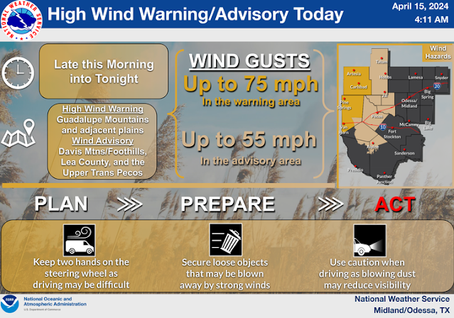
Today will be very windy with areas of blowing dust and Critically Dangerous Fire Weather Conditions areawide! High Wind Warnings and Wind Advisories are in effect today for much of the local area of the state. Southwest to west winds are forecast to increase later this morning to sustained speeds generally in the 25 - 45 mph range with gusts in the 60-70 mph range in the warning and advisories areas. A few localized higher gusts are possible and some of these may exceed 70 mph.
Localized wind damage and power outages may occur during the strongest gusts. This includes the possibility of downed power and utility lines, poles, as well as damage to trees, roofs, barns, sheds, other outbuildings, fences, and agricultural irrigation sprinkler systems.
Any wildland, grass, or forest fires that may develop will have the ability to rapidly spread and grow and become potentially life threatening in the high winds. Please refrain from any outdoor activity that involves the use of flame or sparks today.
Widespread blowing dust will likely develop across southern and southeastern New Mexico this afternoon as well as across parts of West Texas. As always in our more dust prone locations such as freshly plowed, cultivated or exposed farmlands, fields, and highway construction sites the visibility may suddenly drop down to zero with little to no advanced warning during these blinding dust storms.
There Are None So Blind As Those Who "Will - Not" To See...107.


Comments
Post a Comment
Your comments, questions, and feedback on this post/web page are welcome.