Typically Hot Temps For Late June - Rain Returns In About A Week?.


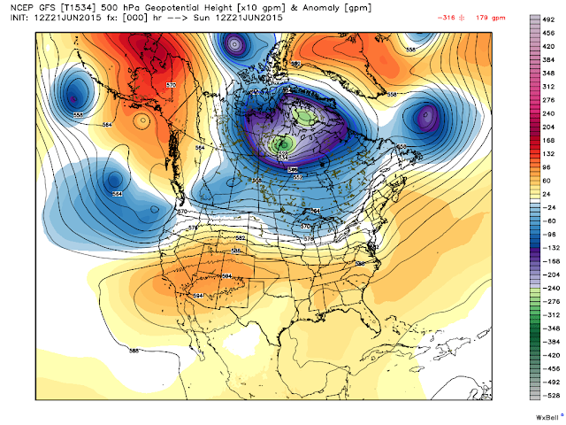
We've undergone a transition recently as the jet stream has relaxed and pulled back to the north in Canada, This is allowing our summer time mid-upper level ridge of high pressure to settle in over the Western US. This has allowed the atmosphere to stabilize therefore effectively shutting down our crop of thunderstorms seen recently.

 Our next best chance for rainfall over the southeastern plains will occur by the end of next weekend into the first of the following week (7-10 days from now). A few hit and miss afternoon thunderstorms will pop up over the Guadalupe, Sacramento, and Capitan Mountains from time to time. Until then we will see typical daytime high temps for late June in the mid-upper 90's with a few days topping the century mark next week. 

The Truth Is Stranger Than Fiction!

Comments

NWS Midland Regional Forecast

NWS Midland Regional Forecast

NWS Midland Regional Forecast

NWS Albuquerque Regional Forecast

NWS Albuquerque Regional Forecast

NWS Albuquerque Regional Forecast

NWS Albuquerque Regional Forecast

NWS El Paso Regional Forecast

NWS Lubbock Regional Forecast

NWS Lubbock Regional Forecast

NWS Lubbock Regional Forecast

NWS Lubbock Regional Forecast

Current Watches In Effect

SPC Mesoscale Discussions

Storm Prediction Center (SPC) Day 1 Severe Weather Outlook

Current NWS National Watches/Warnings In Effect

Current NWS National Watches/Warnings In Effect
Click On The Map For The Latest Updates

New Mexico

Eddy County Plains & Guadalupe Mtn's

Guadalupe Mtn's In Culberson County

Chaves County Plains & Mtn's

Lea County

Lincoln County

Otero County

Current US Temps

Current US Wind Chill/Heat Index Temperatures

NWS Forecast High Temps Today

NWS Forecast Low Temps Tonight

NWS Albuquerque Storm Total Rainfall Forecast

NWS Midland Storm Total Rainfall Forecast

NWS El Paso Storm Total Rainfall Forecast

Average Daily High/Low Temperatures

Average Daily High/Low Temperatures