

Significant High Wind Event Today - Heavy Snow In the Sac's.
Blog Updated @ 10:09 AM MST.
Blog Updated @ 1:35 PM MST.

1-19-2017.
Altocumulus Standing Lenticular Clouds 30 Miles South Of Carlsbad, NM.
Significant High Wind Event Today!

Valid @ 5 AM MST This Morning.
GFS 500 MB (`18,000' MSL) Analysis.

Valid @ 5 AM MST This Morning.

Valid @ 5 AM MST This Morning.

Valid @ 11 AM MST This Morning.
The Jet Stream is aimed at southern New Mexico and West Texas this morning and winds aloft at the 34,000' level are screaming along at 155 knots or 178 mph. A strongly negatively tilted trough of low pressure at the 500 millibar level is also nosing into the area. Not only are the winds aloft strong (around 60 mph at the 700 millibar level or 10,000') but a tight surface pressure gradient will get even tighter as the surface low deepens over Northeastern New Mexico and the Texas Panhandle this afternoon.
(Click On The Link For The Latest Up To Date Information).


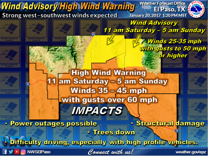

Current Watches & Warnings In Effect For The Local Area.
The bottom line for Southeastern New Mexico and nearby areas...very windy today! Wind Advisories and High Wind Warnings are in effect for the area today. Southwest to west winds will become sustained at around 30 to 40 mph with gusts to near 50-55 mph across parts of Southern New Mexico and West Texas. Westerly winds in Eddy, Chaves, Lincoln, and Otero Counties will become sustained at around 35-50 mph with gusts to 60-70 mph! Westerly winds in the Pine Springs and Guadalupe Pass areas will gust up to around 75 mph...possibly higher.
Areas of blowing dust may develop later this morning and continue into tonight. Sudden drops in the visibility down to near zero with little to no advanced warning will be possible in some locations...especially over and near: freshly plowed or exposed farmlands, open fields and lots, construction sites, and other dust prone areas. Some damage may occur to roofs, west facing windows, power poles and power lines, tree limbs, small sheds and other outbuildings, and agriculture irrigation sprinkler systems.
Blowing and drifting snow will cause difficult and dangerous driving conditions (already occurring) in the Sacramento Mountains today with some areas experiencing near blizzard conditions at times. Near whiteout conditions will develop in some areas along with the possibility of some road closures. Large tree falls could possibly occur in the Sacramento Mtn's at the higher elevations if wind gusts exceed 70 mph.
Winter Storm Warnings and Winter Weather Advisories are in effect today for the Sacramento Mtn's. Snowfall totals will range from 6" to 12" and 7" to 14" or more across the higher elevations above 8,000' with lesser amounts down to around 5,000'.


Snowfall Reports As Of 9 AM MST This Morning:
1.8 SW Cloudcroft 9.5"
0.4 ESE Cloudcroft 6.5"
2 S Alto 5"
1.6 NNE Alto 3.5"
4.6 SSE Nogal 1.3"
1.0 N Ruidoso 1"
The Truth Is Stranger Than Fiction!


Comments
Post a Comment
Your comments, questions, and feedback on this post/web page are welcome.