Weekend Winter Storm Headed To NM.
January 11, 2017.
(CCSL) Cirocumulus Standing Lenticular Clouds.
Southwest Of Carlsbad Over The Guadalupe Mtn's.
Next Major Winter Storm Impacts NM Friday - Sunday.
So far a series of powerful Winter Storms over the past week has produced a peak wind gust at Squaw Mountain of 173 mph, over four feet of snow in the Sierra Nevada Mountains, and near 25" of rain in the lower elevations of the Sierra Nevada Mountains.
Valid @ 5 AM MST This Morning.
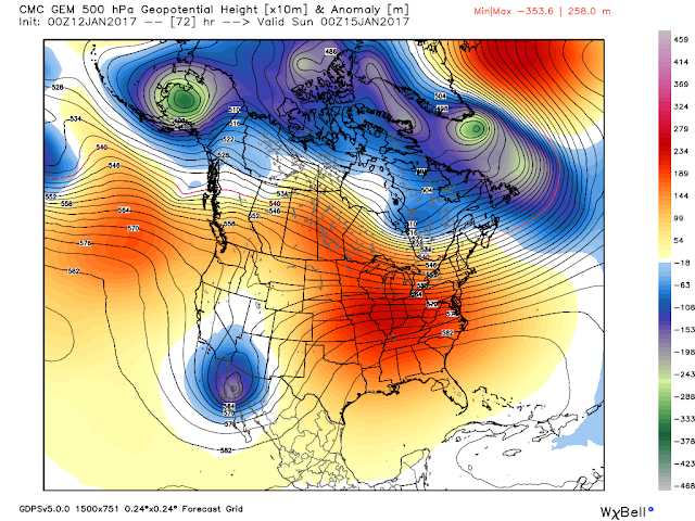
Our next inbound Winter Storm was centered over Northwestern California and Southern Oregon just before sunrise this morning. Forecast models track this potent upper storm southward today into tomorrow.
Valid @ 5 PM MST This Afternoon.
GFS 500 MB Forecast.
Valid @ 5 PM MST Friday.
GFS 500 MB Forecast.
Valid @ 5 PM MST Saturday.
GFS 500 MB Forecast.
Valid @ 5 PM MST Sunday.
So far the computer forecast models agree on the track and strength of this next Winter Storm to impact the Desert Southwest especially New Mexico. A secondary lobe of energy is forecast to split off from the primary cut off upper level low Sunday and Monday and will produce additional precipitation over the area the first of next week as it lags behind the parent storm that will lift out to the northeast.
Yet another record high temperature fell by the wayside yesterday with Roswell's reading of 82ºF. Our string of 70's and 80's will be coming to an end as a cold front enters the area late tonight into Friday.
NWS Watches & Warnings In Effect.
(As Of 7 AM MST This Morning).
Valid @ 5 PM MST Friday.
Valid @ 5 PM MST Saturday.
Valid @ 5 PM MST Sunday.
Current thinking is that coldest air associated with this next modified arctic cold front will remain to far to the north and northeast of Southeastern New Mexico to produce wintry precipitation across the local area. It appears that moderate to even heavy rainfall will be possible with this storm Friday night into Sunday. Local rainfall totals by Monday morning could be in the .50" to 1.00" range with a few spots seeing totals possibly as high as 2.00". This is January right not April?
As the secondary storm lifts out Sunday night into Monday we may have a chance of seeing some light snow as colder air works its way into the region.
Snow levels across the Capitan, Sacramento, and Guadalupe Mtn's will remain high Friday and Saturday and generally range from 9,500' to 10,500'. They will drop down to around 7,500' on Sunday and 5,500' Sunday night...and perhaps to the surface in parts of the local area late Sunday night into Monday morning.
A few thunderstorms will also be possible over the local area this weekend. This is a very strong and complex storm so don't be surprised if there are not some changes in our local forecasts this weekend.
Valid @ 5 AM MST Monday.
Valid @ 5 AM MST Monday.
Local NWS Forecasts.
The Truth Is Stranger Than Fiction!


Comments
Post a Comment
Your comments, questions, and feedback on this post/web page are welcome.