
Fall Freeze Data For New Mexico


MY CoCoRaHS Precipitation Data

NWS Albuquerque 2026 Winter Outlook

NWS Midland Web Page

Click On The Map To Open It Up
NWS Midland Hazardous Weather Outlook

Click On The Image To See The Rest Of The Outlooks
NWS Midland Hazardous Weather Outlook

Click On The Image To See The Rest Of The Outlooks
NWS Midland Hazardous Weather Outlook

NWS Midland Hazardous Weather Outlook

NWS Midland Forecast Graphic
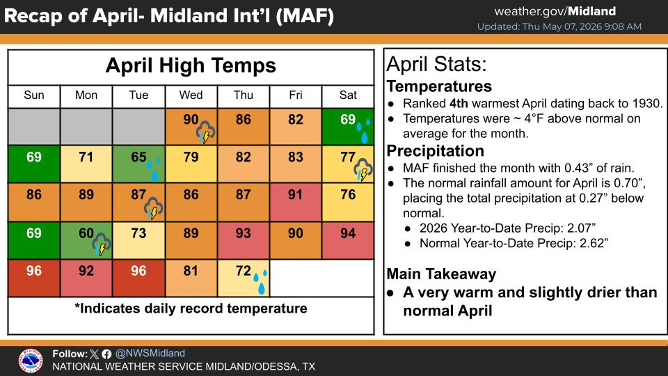
NWS Midland Graphic Forecast

NWS Midland Forecast Graphic

NWS Midland Forecast High Temperatures Today

NWS Midland Forecast Low Temperatures Tonight

NWS Albuquerque Web Page

Click On The Map To Open It Up
NWS Albuquerque Hazardous Weather Outlook

NWS Albuquerque Hazardous Weather Outlook

NWS Albuquerque Forecast Grpahics

NWS Albuquerque Forecast Graphics
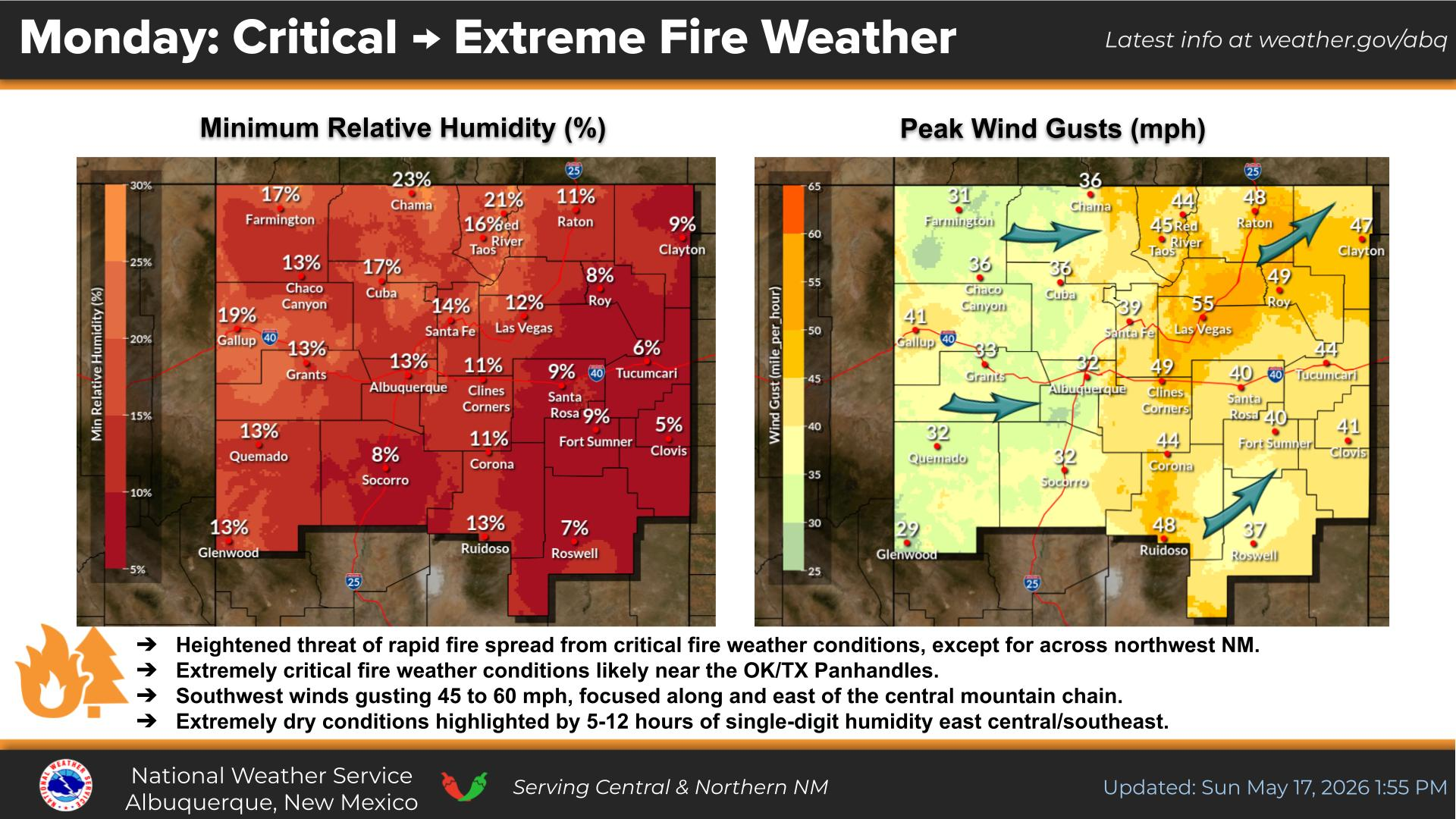
NWS Albuquerque Forecast Graphic

NWS Albuquerque Graphic Forecast

NWS Albuquerque Forecast High Temperatures Today

NWS Albuquerque Forecast Low Temperatures Tonight

NWS Albuquerque Peak Wind Gust Forecast

NWS El Paso Web Page

NWS El Paso Hazardous Weather Outlook

Click On The Image To See The Rest Of The Outlooks
NWS El Paso Hazardous Weather Outlook

Click On The Image To See The Rest Of The Outlooks
NWS El Paso Hazardous Weather Outlook

NWS El Paso Hazardous Weather Outlook

NWS El Paso Graphic Forecast

NWS El Paso Graphic Forecast

NWS El Paso Graphic Forecast

NWS El Paso Graphic Forecast

NWS El Paso Forecast High Temperatures Today

NWS El Paso Forecast Low Temperatures Tonight

NWS Lubbock Web Page

Click On The Map To Open It Up
NWS Lubbock Hazardous Weather Outlook

Click On The Image To See The Rest Of The Outlooks
NWS Lubbock Hazardous Weather Outlook

Click On The Image To See The Rest Of The Outlooks
NWS Lubbock Hazardous Weather Outlook

NWS Lubbock Hazardous Weather Outlook

NWS Lubbock Graphic Forecast

NWS Lubbock Graphic Forecast

NWS Lubbock Graphic Forecast

NWS Lubbock Graphic Forecast
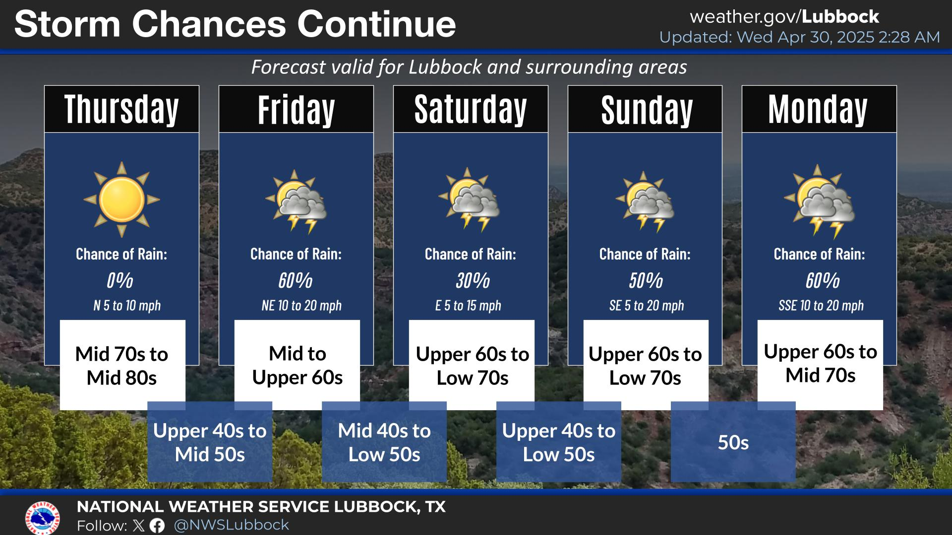
NWS Lubbock Hi Temperature Forecast Today

NWS Lubbock Low Temperature Forecast Tomight

My Rainfall Totals - 2.1 NNW Downtown Carlsbad

My Seasonal Snowfall Totals - 2.1 NNW Downtown Carlsbad

Comments
Post a Comment
Your comments, questions, and feedback on this post/web page are welcome.