My Current Weather

Wednesday, February 12, 2020

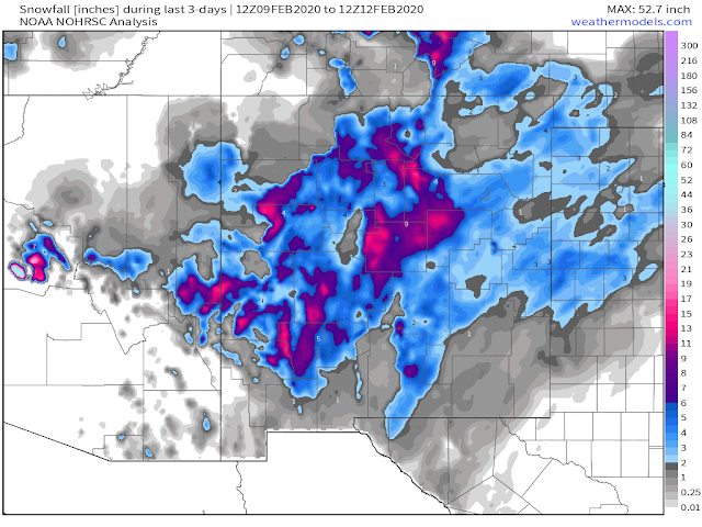
New Mexico Reported Snowfall Totals - Wednesday, Feb 12, 2020.


Blog Updated At 4:16 PM MST Wednesday.


Past 3-Days.


February-To-Date.
 (1st-12th).


Season-To-Date Totals.
(Oct 1st, 2019 - Feb 12th, 2020).


Texas Season-To-Date Totals.
(Oct 1st, 2019 - Feb 12th, 2020).


Snow Cover This Wednesday Morning.


Look closely and you can pick out the snow cover band over the Guadalupe's with a streak of snow extending northeast to Brantley Lake and then on to Loco Hills this morning. Another band runs from just southwest of the Hagerman area northward through Roswell and the Bitter Lakes Wildlife Refuge. Widespread snow cover is evident over the Capitan and Sacramento mountains, and west of Tatum northward over the Eastern Plains.

(Day Snow/Fog False Color Image).


Areas shaded red indicate snow cover this Wednesday morning, and areas shaded in white are clouds. Green is the ground.

(2-Day Totals As Of 8 AM MST This Wednesday Morning).


SNOW 
 •  null GASCON - 13.0 in.
 •  null TIJERAS - 13.0 in.
 • 6 ESE MOGOLLON - 13.0 in.

 • 3 N CHILILI - 12.6 in.
 • 3 ENE PONDEROSA - 12.2 in.
 • 2 N MOUNTAINAIR - 12.0 in.
 • 1 S MOUNTAINAIR - 12.0 in.
 • 4 NW SANDIA PARK - 12.0 in.

 • 1 ESE SEDILLO - 11.5 in.
 • 2 NNW EDGEWOOD - 11.3 in.
 • 2 SW MIERA - 11.3 in.
 • 2 WSW EDGEWOOD - 11.0 in.
 •  null EDGEWOOD - 11.0 in.
 • 8 SSW RED RIVER - 11.0 in.

 • 1 WSW PONDEROSA - 10.5 in.
 • 1 ENE SAN ANTONITO - 10.0 in.
 • 8 SW ROCIADA - 10.0 in.
 • 5 SW BONITO LAKE - 10.0 in.
 •  null ESTANCIA - 10.0 in.

 • 1 SW SAN ANTONITO - 9.7 in.
 • 2 W DATIL - 9.6 in.
 • 8 WNW WILLARD - 9.3 in.
 • 1 WSW SEDILLO - 9.2 in.
 • 7 ESE CUBA - 9.0 in.
 • 4 E SANDIA PARK - 9.0 in.
 •  null SAPELLO - 9.0 in.
 • 3 ESE ANGEL FIRE - 9.0 in.
 • 6 SSE LUNA - 9.0 in.
 • 6 SSE GOLDEN - 9.0 in.

 • 1 SSW SAN ANTONITO - 8.9 in.
 •  null FENCE LAKE - 8.5 in.
 • 2 W PONDEROSA - 8.5 in.
 • 1 NNW CEDAR CREST - 8.1 in.
 • 8 NE ARROYO SECO - 8.0 in.
 • 2 E SAN PABLO - 8.0 in.
 •  null CEDAR CREST - 8.0 in.
 • 5 SSE LLANO LARGO - 8.0 in.
 • 1 S SEDILLO - 8.0 in.
 • 8 S FENCE LAKE - 8.0 in.
 •  null TECOLOTITO - 8.0 in.
 • 7 ESE CHUPADERO - 8.0 in.

 • 2 NNW EDGEWOOD - 7.5 in.
 • 1 ESE TRUCHAS - 7.5 in.
 • 1 N MORIARTY - 7.3 in.
 • 2 E GLORIETA - 7.2 in.
 • 11 WSW BLUEWATER LAKE - 7.0 in.
 •  null JEMEZ SPRINGS - 7.0 in.
 • 2 N EDGEWOOD - 7.0 in.
 • 2 SE MANZANO - 7.0 in.
 • 5 WNW LOS ALAMOS - 7.0 in.
 •  null DIXON - 7.0 in.
 • 2 SW PECOS - 7.0 in.
 • 5 E EL MORRO - 7.0 in.
 • 6 SE PLACITAS - 7.0 in.
 •  null SANDIA PARK - 7.0 in.
 • 9 E CUBA - 7.0 in.

 • 3 ENE MIERA - 6.5 in.
 • 1 NNW ROMEROVILLE - 6.2 in.
 • 2 SE SOUTH SAN YSIDRO - 6.2 in.
 • 3 NW TRES RITOS - 6.0 in.
 • 6 W LOS ALAMOS - 6.0 in.
 • 12 SSE COYOTE - 6.0 in.
 • 2 NW EL RITO - 6.0 in.
 • 3 ENE MAGDALENA - 6.0 in.
 • 15 ESE CORONA - 6.0 in.
 •  null LAS VEGAS - 6.0 in.
 • 1 SSE DILIA - 6.0 in.
 • 13 ESE CUBA - 6.0 in.
 • 11 ENE RED RIVER - 6.0 in.
 • 6 WNW TERERRO - 6.0 in.
 •  null QUEMADO - 6.0 in.
 • 16 W CORONA - 6.0 in.

 • 2 NNE ROWE - 5.8 in.
 • 3 E LOS ALAMOS - 5.8 in.
 •  null ARROYO HONDO - 5.6 in.
 • 2 NE PLACITAS - 5.5 in.
 • 9 S TIJERAS - 5.5 in.
 • 7 NW SANTA FE - 5.3 in.
 • 5 NW LAMY - 5.3 in.
 •  null RAMAH - 5.2 in.
 • 1 WSW LOS ALAMOS - 5.0 in.
 • 4 W MOUNTAINAIR - 5.0 in.
 • 1 ENE SAN ANTONITO - 5.0 in.
 • 1 ESE ZUNI PUEBLO - 5.0 in.
 •  null TORREON NAVAJO MISSION - 5.0 in.
 • 2 NNW SEDILLO - 5.0 in.
 • 11 ENE AMALIA - 5.0 in.
 • 9 SE MAGDALENA - 5.0 in.
 • 6 S TEXICO - 5.0 in.
 • 1 ENE LUNA - 5.0 in.
 • 8 SE EAGLE NEST - 5.0 in.
 •  null CONCHAS - 5.0 in.

 • 3 SSW ENCINO - 4.6 in.
 • 3 WSW RIO RANCHO - 4.6 in.
 • 5 WSW ARROYO HONDO - 4.6 in.
 • 1 W CLAYTON - 4.5 in.
 • 2 E SOCORRO - 4.5 in.
 • 1 SE SAN GERONIMO - 4.4 in.
 • 4 NNW LAMY - 4.4 in.
 • 2 SW BERNALILLO - 4.3 in.
 •  null MIAMI - 4.3 in.
 • 1 WSW MIAMI - 4.3 in.
 • 6 SSE SANTA FE - 4.2 in.
 • 1 NE POJOAQUE PUEBLO - 4.2 in.
 • 2 NE SOCORRO - 4.1 in.
 • 1 W MCCARTYS - 4.1 in.
 • 4 NNW EDGEWOOD - 4.1 in.
 • 5 NNW LAMY - 4.0 in.
 • 8 NW ALBUQUERQUE - 4.0 in.
 • 1 SSW MADRID - 4.0 in.
 • 3 NW SANDIA PUEBLO - 4.0 in.
 • 2 NE RUIDOSO - 4.0 in.
 • 7 NNW AGUA FRIA - 4.0 in.
 • 8 NNW GLORIETA - 4.0 in.
 • 1 N CANONES - 4.0 in.
 • 5 SSW TOADLENA - 4.0 in.
 • 3 E GALLUP - 4.0 in.
 • 3 NNE AGUA FRIA - 4.0 in.
 • 9 ENE SHADY BROOK - 4.0 in.
 • 1 W SANTA FE - 4.0 in.
 •  null JEMEZ SPRINGS - 4.0 in.
 • 1 ESE ABBOTT - 4.0 in.
 • 3 N SANTA FE - 4.0 in.
 • 3 NE BONITO LAKE - 4.0 in.
 •  null RED RIVER - 4.0 in.
 •  null POJOAQUE - 4.0 in.
 • 1 ESE RIO RANCHO - 4.0 in.
 •  null SEDAN - 4.0 in.
 • 2 W ANGUS - 4.0 in.
 •  null SANTA FE - 4.0 in.
 • 2 SW RIO RANCHO - 4.0 in.
 • 4 W RIO RANCHO - 4.0 in.
 • 3 ENE TUCUMCARI - 4.0 in.
 • 3 N FENCE LAKE - 4.0 in.
 •  null EAGLE NEST - 4.0 in.
 • 7 E CANJILON - 4.0 in.
 • 15 NW ALBUQUERQUE - 4.0 in.
 •  null ANGEL FIRE - 4.0 in.
 • 3 NW SANDIA PUEBLO - 4.0 in.
 • 5 ESE BLACK LAKE - 4.0 in.

 • 3 NNE LOS CERRILLOS - 3.9 in.
 • 5 ESE BLACK LAKE - 3.8 in.
 • 3 SSE MAGDALENA - 3.7 in.
 •  null TSE BONITO - 3.7 in.
 • 1 SSE BERNALILLO - 3.6 in.
 • 2 SW AGUA FRIA - 3.6 in.
 • 2 WSW RIO RANCHO - 3.5 in.
 • 4 WSW RIO RANCHO - 3.5 in.
 • 2 WSW HERNANDEZ - 3.5 in.
 • 11 ENE BELL RANCH - 3.5 in.
 • 3 ESE MIERA - 3.5 in.
 •  null OJO ENCINO - 3.5 in.
 • 5 NNW AGUA FRIA - 3.5 in.
 • 3 WNW BERNALILLO - 3.5 in.
 • 4 WNW RIO RANCHO - 3.5 in.
 • 3 W RIO RANCHO - 3.5 in.
 • 1 S SANTA FE - 3.5 in.
 • 4 NW LAMY - 3.4 in.
 • 10 NNW SEDAN - 3.3 in.
 •  null JACONITA - 3.3 in.
 • 5 NE ALTO - 3.3 in.
 • 2 WSW SANTA FE - 3.0 in.
 • 13 NW SEDAN - 3.0 in.
 • 2 SW AGUA FRIA - 3.0 in.
 • 5 NW LAMY - 3.0 in.
 •  null ANGEL FIRE - 3.0 in.
 • 1 SSW FORT SUMNER - 3.0 in.
 •  null CAPULIN - 3.0 in.
 • 1 N ROSWELL - 3.0 in.
 • 7 SSE CUERVO - 3.0 in.
 • 1 ENE SANTA FE - 3.0 in.
 • 2 SE ALTO - 3.0 in.
 •  null ESPANOLA - 3.0 in.
 • 1 S RIO RANCHO - 3.0 in.
 • 1 W LINDRITH - 3.0 in.

 • 3 WSW CORRALES - 2.9 in.
 • 1 SSE GALLUP - 2.7 in.
 • 1 W GRANTS - 2.7 in.
 • 2 N CORRALES - 2.7 in.
 • 1 NW CORRALES - 2.7 in.
 • 2 SSW LOS CORDOVAS - 2.6 in.
 • 1 W CLAYTON - 2.5 in.
 • 5 ESE SANDIA PUEBLO - 2.5 in.
 •  null PORTALES - 2.5 in.
 • 3 N MILAN - 2.5 in.
 • 8 WNW ALBUQUERQUE - 2.5 in.
 • 2 WNW CLOVIS - 2.5 in.
 • 2 S YESO - 2.5 in.
 •  null CONCHAS DAM - 2.5 in.
 • 6 SSE SANTA FE - 2.5 in.
 • 7 SE ALBUQUERQUE - 2.5 in.
 •  null WHITE ROCK - 2.5 in.
 • 5 E SUMNER LAKE - 2.5 in.
 • 2 NW ROSWELL - 2.5 in.
 • 1 N RUIDOSO - 2.5 in.
 • 2 NNE CLOVIS - 2.5 in.
 • 4 WSW RIO RANCHO - 2.4 in.
 • 1 SSE ESCONDIDA - 2.4 in.
 • 1 WNW EL RANCHO - 2.3 in.
 •  null SANDIA PARK - 2.3 in.
 • 8 S HAYDEN - 2.3 in.
 • 3 SW PORTALES - 2.3 in.
 • 2 W DATIL - 2.3 in.
 • 7 SE YATES - 2.3 in.
 • 4 N NEWKIRK - 2.2 in.
 • 3 SW PORTALES - 2.2 in.
 • 6 NW ALBUQUERQUE - 2.0 in.
 • 1 NNE CORRALES - 2.0 in.
 • 2 SW RIO RANCHO - 2.0 in.
 •  null CIMARRON - 2.0 in.
 •  null PORTALES - 2.0 in.
 • 4 NNW TRES RITOS - 2.0 in.
 • 7 NNW ALBUQUERQUE - 2.0 in.
 • 5 ESE RED RIVER - 2.0 in.
 • 22 WNW HAYDEN - 2.0 in.
 • 5 NW CANONES - 2.0 in.
 • 6 NNW ALBUQUERQUE - 2.0 in.
 • 5 NW CHAMA - 2.0 in.
 • 1 ESE MENTMORE - 2.0 in.
 • 2 ENE GALLUP - 2.0 in.
 • 8 SSW SAN MIGUEL - 2.0 in.
 • 11 NNW CANON PLAZA - 2.0 in.
 • 4 WNW RIO RANCHO - 2.0 in.
 • 3 NNE ROSWELL - 2.0 in.
 • 1 ESE CLOVIS - 2.0 in.
 •  null CHAMA - 2.0 in.

 • 6 NNW ALBUQUERQUE - 1.8 in.
 • 1 W MCCARTYS - 1.8 in.
 • 1 ENE CORRALES - 1.5 in.
 • 6 NW ALBUQUERQUE - 1.5 in.
 • 8 SE ALBUQUERQUE - 1.5 in.
 • 5 NW ALBUQUERQUE - 1.5 in.
 • 3 NW CARNUEL - 1.5 in.
 • 2 WNW CLAYTON - 1.5 in.
 • 2 E SEDILLO - 1.4 in.
 • 1 W CORONA - 1.3 in.
 • 3 S SANTA FE - 1.2 in.
 • 6 NNW ROSWELL - 1.2 in.
 • 4 NW ALBUQUERQUE - 1.1 in.
 • 4 NW ALBUQUERQUE - 1.1 in.
 • 4 NW ALBUQUERQUE - 1.1 in.
 •  null CAPITAN - 1.0 in.
 • 6 NE ALBUQUERQUE - 1.0 in.
 • 7 SW ALBUQUERQUE - 1.0 in.
 •  null NATL RADIO ASTRONOMY OBS - 1.0 in.
 • 8 ESE ALBUQUERQUE - 1.0 in.
 • 5 SE ALBUQUERQUE - 1.0 in.
 • 4 W ALBUQUERQUE - 1.0 in.
 • 2 ENE TAOS - 1.0 in.
 • 2 SSW SANTA ANA PUEBLO - 1.0 in.
 • 1 N RATON - 1.0 in.
 • 5 SSW PORTALES - 1.0 in.
 • 9 NE ALBUQUERQUE - 1.0 in.
 •  null SAN FIDEL - 1.0 in.
 • 3 W LOGAN - 1.0 in.
 • 5 WSW ALBUQUERQUE - 1.0 in.
 • 2 S VALENCIA - 1.0 in.

 • 3 W ALBUQUERQUE - 0.8 in.
 • 4 ESE ALBUQUERQUE - 0.8 in.
 • 2 SSE ALBUQUERQUE - 0.7 in.
 • 1 E VALENCIA - 0.6 in.
 • 4 SSE ALBUQUERQUE - 0.5 in.
 • 8 W SANDIA PARK - 0.5 in.
 • 1 S PERALTA - 0.5 in.
 • 5 S ALBUQUERQUE - 0.5 in.
 • 2 SSE PERALTA - 0.5 in.
 • 4 WSW JARALES - 0.5 in.
 •  null RIO COMMUNITIES - 0.5 in.
 • 2 WNW PLACITAS - 0.5 in.
 • 5 N ROSWELL - 0.5 in.
 • 3 E ALBUQUERQUE - 0.5 in.
 • 1 SSW RUIDOSO - 0.5 in.
 • 7 E ALBUQUERQUE - 0.4 in.
 • 5 S ALBUQUERQUE - 0.4 in.
 • 7 ESE KENNA - 0.3 in.
 • 8 SW ALBUQUERQUE - 0.3 in.
 • 8 NNW OMEGA - 0.3 in.
 • 7 W SANDIA PARK - 0.3 in.
 • 5 ESE ALBUQUERQUE - 0.3 in.
 • 5 E ALBUQUERQUE - 0.2 in.
 •  null SAN ANTONIO - 0.2 in.
 • 4 NW CARNUEL - 0.2 in.
 • 4 NE ALBUQUERQUE - 0.2 in.

 •  null FARMINGTON - T in.
 • 5 E ALBUQUERQUE - T in.
 • 3 NE ALBUQUERQUE - T in.
 • 5 NW ALBUQUERQUE - T in.
 • 6 ENE ALBUQUERQUE - T in.
Last updated:
0943 AM 02/12/2020

Thoughts On Our Latest Winter Storm.

Ski Apache reported 6" of new snow this morning bringing their seasonal total to 95".

What a letdown here in the Pecos Valley. What looked like a good opportunity for some decent snowfall totals ended up falling flat for many of us. Most disappointing I think was the mountains where Sunspot recorded a storm total of only 6.8", Cloudcroft 2.5", and Ruidoso 4.0". This when 6" to 12" or more were forecast, while Ski Apache was expecting to see around 18". 

Runyan Ranches located on U.S. Hwy 82 a couple of miles east of Elk in southwest Chaves County picked up 6" of snow and noted a low temperature of 8º.

Carlsbad officially had 1.0" of snowfall and an inch on the ground at 6 PM MST yesterday evening. I recorded a storm total of 0.6" with a half of an inch on the ground at 9 pm last night. Rain changed over to sleet and snow yesterday morning and continued off and on throughout the day into the early evening. My temperature hovered around 34º for most of the day, and that with a warm ground melted the snow and sleet as it fell. Otherwise, we could have ended up with about 2.0" on the ground. 

My seasonal snowfall total to-date is now up to 4.8", making this the snowiest February for me since 2011 when 5.9" fell that month. It's also the snowiest season in the past five years (4.7" so far) since the winter of 2015/2016 when 23.0" fell.

NWS Midland Local Snowfall Reports.


The Truth Is Stranger Than Fiction - And Sometimes It Hurts!
No comments:

Post a Comment

Your comments, questions, and feedback on this post/web page are welcome.

NWS Albuquerque Burn Scar Matrix Forecast

Current NWS Watches/Warnings In Effect

New Mexico

Eddy County

Chaves County Plains & Mtn's

Culberson County

Lea County

Lincoln County

Otero County

Current US Temps

Current US Wind Chill/Heat Index Temperatures

NWS Midland Forecast

NWS Albuquerque Forecast

NWS Albuquerque Forecast

NWS El Paso Forecast

NWS Lubbock Forecast

NWS Lubbock Forecast

NWS Lubbock Forecast

Average Daily High/Low Temperatures & Rainfall

Average Daily High/Low Temperatures & Rainfall