

Isolated T-Storm Possible Today.
Isolated T- Storms Possible Today.

Limited low-level moisture and instability combined with a shortwave traversing the area will combine with afternoon heating to produce a few isolated to widely scattered thunderstorms this afternoon and evening across the southeastern plains. Downdraft cape values (DCAPE) in excess of 1,000 j/kg suggest that the main severe weather threat from these thunderstorms will be strong wind gusts in excess of 58 mph. Small hail could also occur with the strongest storms perhaps up to around nickel size. A few of the strongest storms may produce moderate to locally heavy rainfall. Overall most of us will not get wet. Of concern will be any dry lightning strikes that may start a few wildfires.
Strong West Winds Return.


Southwesterly winds will begin to pick up Tuesday afternoon ahead of a strong mid/upper-level storm swinging east across the central Rockies Tuesday and Wednesday. These gusts will be in the 30-40 mph range Tuesday afternoon.
Wednesday will be the windiest day with southwesterly winds gusting up to around 30-40 mph across the lower valleys and plains Wednesday. With a few higher gusts possible. The mountains will see these winds gusting up into the 45-60 mph range.
Localized areas of blowing dust will be possible especially in and near our noramlly dust prones locations during the strongest gusts.
Today.

Tuesday.

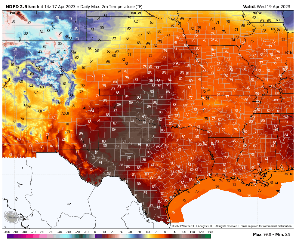
Wednesday.
Thursday.

Friday.

Our afternoon high temperatures will average some 5º to 10º above normal this week.
A strong cold front will drop southward through the local area Friday night dropping our temps slightly below normal for the weekend by some 5º to 10º. Overall our dry spring pattern shows little hope of breaking anytime soon.
On This Day In History - April 17th, 1970.
1970 (17th-18th): A very rare nighttime outbreak of tornadoes struck populated centers in the Texas Panhandle and South Plains region causing extensive damage and claiming the lives of 23 people. What made this nighttime outbreak so unusual was that some of the tornadoes occurred during fog, at times dense, and were accompanied by very little lightning making
nighttime spotting almost impossible.
nighttime spotting almost impossible.
The weather for much of the afternoon over the region did not immediately suggest a
pattern that was favorable for such a historic event as abundant fog and low clouds prevailed with temperatures only in the 50s and 60s. However, observations in central Texas revealed unusually moist air for late April with dewpoints near 70° channeling northwest into West Texas on gusty southeasterly winds. An east-west oriented warm front began surging north into the South Plains by late afternoon at which point a dryline in southeast New Mexico erupted with scattered supercells.
pattern that was favorable for such a historic event as abundant fog and low clouds prevailed with temperatures only in the 50s and 60s. However, observations in central Texas revealed unusually moist air for late April with dewpoints near 70° channeling northwest into West Texas on gusty southeasterly winds. An east-west oriented warm front began surging north into the South Plains by late afternoon at which point a dryline in southeast New Mexico erupted with scattered supercells.
Although additional weather data is sparse for this event, it is believed that at least one of these supercells tracked northeast all the way into the southern South Plains after sunset at which point the first violent tornado touched down in Whiteface before striking Whitharral. The Witharral Postmaster said "The tornado was not the usual funnel shape, but more like a rain cloud. It hit Whitharral like a ball of fire, lighting the entire town with electricity picked up when it hit power lines". This half-mile wide F4 tornado caused 20 injuries and $2M in damage
in Whiteface alone with four injuries and $700,000 damage reported in Whitharral. A testament to the instability and wind shear in place, this tornadic storm also produced giant hail to four inches in diameter.
in Whiteface alone with four injuries and $700,000 damage reported in Whitharral. A testament to the instability and wind shear in place, this tornadic storm also produced giant hail to four inches in diameter.
Additional significant tornadic supercells developed late in the night near Lazbuddie, Cotton Center and Tulia. All of these were recorded as long-tracked F4 tornadoes with the Lazbuddie tornado perhaps the most significant of them all (from a meteorological perspective) in
that it was on the ground for just over two hours from Lazbuddie all the way into the northeast Texas Panhandle where the city of Pampa suffered 10 injuries and damage to 20 homes. In reality, this tornado may have been comprised of a series of dissipating and developing tornadoes throughout its lengthy path; however, more recent outbreaks have confirmed that such long-lived single tornadoes are indeed possible.
that it was on the ground for just over two hours from Lazbuddie all the way into the northeast Texas Panhandle where the city of Pampa suffered 10 injuries and damage to 20 homes. In reality, this tornado may have been comprised of a series of dissipating and developing tornadoes throughout its lengthy path; however, more recent outbreaks have confirmed that such long-lived single tornadoes are indeed possible.
The Cotton Center tornado was observed to feature a companion tornado one-to-two miles away near the start of its path. This F4 tornado caused considerable damage to the southwest and northeast areas of Plainview where nearly every structure was leveled with some homes swept clean leaving only a concrete slab. Forty people were injured and two killed in Plainview alone. This tornado followed a nearly perfect straight line northeast into Silverton where a 14 year-old girl was killed. Interestingly, eyewitness accounts in Plainview stated that
there was little noise associated with this tornado when it struck and that it was completely hidden from view due to thick fog and little lightning.
there was little noise associated with this tornado when it struck and that it was completely hidden from view due to thick fog and little lightning.
Near Silverton, this tornado deposited two 50-foot tall tanks of grain 1/4 mile from their origin and a massive 1.5 million bushel tank was moved 50 feet. Farther north, the Tulia tornado fortunately began northeast of the city; however, in similar fashion to the other tornadoes, this cyclone moved northeast in a straight line passing northwest of Clarendon before dissipating north of McLean. Tragically, 15 people were killed west-northwest of Clarendon, most of whom lived in mobile homes at the Sherwood Shores resort community at the Green Belt Reservoir.
Here alone, 172 mobile homes were completely destroyed. This tornado also blew several tank cars off the railroad tracks near I-40. The exact number of tornadoes from this outbreak is unknown; largely due to the unusual time of this event and the lack of comprehensive storm damage surveys at the time. Considering the magnitude of this outbreak, it is likely that
several more tornadoes occurred than only the four recorded in the official 1970 Storm Data publication. Interestingly, on more than one occasion eyewitnesses reported multiple funnel clouds in the vicinity of some of the main tornadoes; however, it was never determined if any of these funnels became tornadic. Not adjusting for inflation, this entire outbreak exceeded $10M in property losses. Just three weeks later, another violent nighttime tornado would occur on the South Plains; this time in the city of Lubbock. Much of the significance of the April 17th outbreak would soon be overshadowed by the Lubbock F5 tornado.
several more tornadoes occurred than only the four recorded in the official 1970 Storm Data publication. Interestingly, on more than one occasion eyewitnesses reported multiple funnel clouds in the vicinity of some of the main tornadoes; however, it was never determined if any of these funnels became tornadic. Not adjusting for inflation, this entire outbreak exceeded $10M in property losses. Just three weeks later, another violent nighttime tornado would occur on the South Plains; this time in the city of Lubbock. Much of the significance of the April 17th outbreak would soon be overshadowed by the Lubbock F5 tornado.
There Are None So Blind As Those Who "Will - Not" To See...107.


Comments
Post a Comment
Your comments, questions, and feedback on this post/web page are welcome.