Prolonged Damaging High Wind - Blowing Dust Event Tuesday.
North Of Artesia On State Hwy #2.
On The Eddy/Chaves County Line.
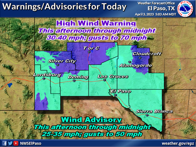
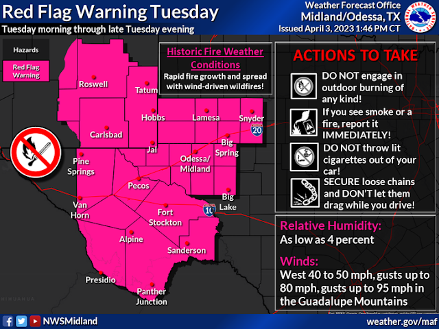
Widespread strong to potentially damaging winds will impact the region through Tuesday. Southwest wind gusts of 60 to 70 mph will transition out of the west Tuesday with gusts of 65 to 75 mph. A few spots in Lincoln and southwest Chaves counties may reach 85 mph. Tuesday. Very dangerous fire weather conditions will also occur with extremely dry air in place over the region. Blowing dust may reduce visibility below one mile at times. Outdoor burning should not be done as wildfires will spread rapidly. Hazardous crosswinds will make travel difficult to impossible for large and high profile vehicles.
Prolonged Damaging High Wind - Blowing Dust Event Tuesday.
Tuesday's weather across most of New Mexico and nearby West Texas simply will be awful! Widespread damaging westerly winds sustained at 35 to 50 mph with gusts of 65-85 mph now appear likely. Peak wind gusts in the Guadalupe mountains may equal or exceed 100 mph!
These high winds will be capable of causing roof damage with some roofs possibly being blown off, outbuildings may be damaged or blown away. Power lines and utility lines may be blown down with power and utility poles blown down. Power outages are possible. Trees may be blown down along with tree limbs. North -south facing fences may be blown down. Some west facing windows could also be blown out especially in gusts above 70 mph. High profile vehicles may be blown off highways and roads...especially north/south facing roads.
Hardest hit areas will be the Sacramento, Capitan, and Guadalupe mountains. Along with the southeastern and eastern plains eastward into West Texas. Some of the highest wind gusts may occur on the east slopes of the Sacramento mountains out onto the Chaves and Eddy County plains. As well as in the Guadalupe mountains.
Widespread Blowing Dust Tuesday!
Blowing dust is expected to become widespread as the day wears on. Ahead of the approaching Pacific cold front the visibility easily could drop below 1 mile in many locations that experience wind gusts over 60 mph especially at the lower elevations.
Blinding dust storms (brown outs) will likely occur suddenly with little to no advanced warning especially over and near these dust prone areas. Open or exposed farmlands, fields, lots, and highway road construction areas. The visibility may literally drop down to feet making it impossible to drive. Remember the area has a long history of these blinding dust storms and multi-vehicle accidents with injuries and fatalities.
Potential Historic Fire Weather Conditions Tuesday!
Please avoid any type of outdoor activity that involves the use of sparks or flame!
High Wind Event March 12, 2006.
I took a look at some of the analog events for this pattern and the March 12, 2006 high wind event comes to mind.
The Artesia Airport clocked a peak wind gust out of the west at 84 mph. The front windows of the Sherwood Williams Paint Store in town were blown out. Large trees were uprooted and power lines, utility lines, and power poles were blown down along with tree limbs. Roof damage occurred (shingles mostly) and agriculture irrigation side role sprinklers were blown away.
An emergency flare at a gas plant near McDonald, New Mexico started a wildfire that grew to nearly 100,000 acres. Sustained wind speeds of 35 to 45 mph with gusts to 84 mph and very low relative humidity values contributed to the rapid growth and spread of this fire. These high winds occurred as both upper-level height gradients and surface pressure gradients tightened as a strong upper-level low pressure system approached southeastern New Mexico.
The fire began around 10:30am MST and was visible on satellite by 11:00am MST. The NWS first learned of the fire through a cooperative observer in Tatum, New Mexico, who submitted a storm report online at 11:42am MST. New Mexico State Road 206 was closed by the New Mexico State Police between Tatum and McDonald due to the fire.
News reports in later days indicated that the final acreage of the burn area was 92,390 acres. The fire was contained Monday, March 13th after burning down the U.S. Post Office, two primary residences, four abandoned homes, three barns, and several pieces of fire equipment. Two dozen fire departments fought to put out the fire and one man suffered burns and was treated at a burn center in Lubbock, Texas. All of the destroyed properties above were taken into account for the property damage estimate above. It is not known at this time if any crops were being grown in the area of the fire.
Take a look at my blog post (and photos) from the February 28, 2012 high wind and blowing dust event. A blinding dust storm at the intersection of US Hwy 285 and north 26th street. A 17 vehicle pile up in a raging dust storm injured 10 people.
There Are None So Blind As Those Who "Will - Not" To See...107.


Comments
Post a Comment
Your comments, questions, and feedback on this post/web page are welcome.