

Widespread Prolonged Damaging High Wind - Blowing Dust Event Tuesday!

Southwest Of Lubbock, TX.

Widespread Major High Wind - Blowing Dust Event Tuesday!


This may surprise some but April can often be as bad if not worse than March with high winds and blowing dust events. Current forecasts and model data indicate that this upcoming event may be as bad as the February 22nd wind/dust storm, and the February 26th wind/dust storm. Should the jet stream and strong mid-level winds shift just a tad further to the south than currently forecast.
Update To Watches & Warnings At 2:03 PM MDT Sunday.
Update At 3:40 PM MDT.
Southeastern Plains:
A Wind Advisory is in effect for Eddy County from 11 AM MDT Monday through 8 AM MDT Tuesday morning. Southwest winds will become sustained at 30 to 45 mph with gusts to 55 mph!
A High Wind Watch is in effect for Eddy and Culberson Counties from Tuesday morning through Tuesday evening. Monday will be windy with southwest winds increasing to sustained speeds of 30 to 45 mph with gusts of 55 mph. These strong winds will continue overnight into Tuesday morning. Then becoming westerly sustained at 40 to 60 mph with gusts to 80 mph Tuesday into Tuesday evening!
A Wind Advisory is in effect for Chaves County from Noon MDT through 9 PM MDT Monday. Southwest winds will become sustained at 25 to 35 mph with gusts to 50 mph!
A High Wind Warning is in effect for Chaves County from 6 AM MDT Tuesday morning through 9 PM MDT Tuesday evening. Westerly winds are forecast to become sustained at 40 to 50 mph with gusts to 70 mph!
A Wind Advisory is in effect for eastern Lincoln County and southwest Chaves County from 9 AM MDT Monday morning through 6 PM MDT Monday afternoon. Southwest winds becoming sustained at 25 to 35 mph with gusts to 55 mph!
A High Wind Warning for easter Lincoln County and southwestern Chaves County from 6 PM MDT Monday afternoon through 9 PM MDT Tuesday night. West winds becoming sustained at 40 to 50 mph with gusts to 75 to 80 mph!.
A Wind Advisory is in effect for Lea County and parts of West Texas including the Tatum, Hobbs, Lovington, Van Horn, and Fort Davis areas. From 11 AM MDT Monday through 8 AM MDT Tuesday. Southwest winds will become sustained at 25 to 35 mph with gusts to 50 mph!
A High Wind Watch is in effect for Lea County and parts of West Texas including the Tatum, Hobbs, Lovington, Van Horn, and Fort Davis areas. From Tuesday morning through Tuesday evening. Southwest winds will become sustained at 30 to 50 mph with gusts to 65 to 70 mph!
Guadalupe Mountains:
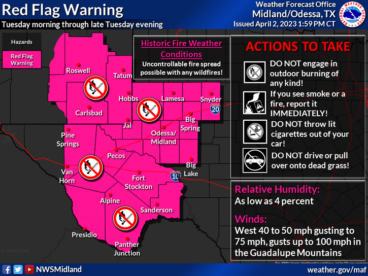
A High Wind Warning is in effect for the Guadalupe mountains of Eddy County, and Culberson County in West Texas from 11 AM MDT Monday morning through 2 AM MDT Wednesday morning. On Monday west winds will be sustained at 35 to 55 mph with gusts to 75 mph!
On Tuesday Westerly winds are forecast to become sustained at 50 to 70 mph with gusts near 100 mph!
Northern Sacramento Mountains:
A High Wind Watch is in effect for Southwestern Chaves and Lincoln Counties from Monday evening through Tuesday evening. Westerly winds are forecast to become sustained at 35 to 50 mph with gusts to 75 mph!
Southern Sacramento Mountains:
A High Wind Warning is in effect from 3 PM MDT Monday afternoon through 9 PM MDT Tuesday evening. Westerly winds are forecast to become sustained at 30 to 50 mph with gusts to 70 mph!
Southern New Mexico:
A Wind Advisory is in effect for the southern one third of New Mexico including the Tularosa Basin from 3 PM MDT Monday afternoon through 9 PM MDT Tuesday night. West winds sustained at 25 to 40 mph with gusts to 50 mph are forecast.
These hIgh winds (especially on Tuesday) across the area may down trees, power lines, utility lines, power and utility poles. This could lead to power outages. Wind damage to homes, roofs, shingles, barns, sheds, and other outbuildings may occur. Some west facing windows may be blown out in the stronger gusts above 70 mph. Vehicles traveling on north/south oriented roads and highways may be blown over. Especially high profile vehicles such as semi trucks, school buses, and campers.
Widespread blowing dust is expected over much of the area Monday afternoon through Tuesday night. Many areas may see the visibility drop down to less than 1/2 of a mile. Dust prone locations such as freshly plowed or exposed farmlands, fields, lots, and high construction sites will experience sudden drops in the visibility down to zero with little to no advanced warning in the higher gusts. Travel upon some roads and highways may become difficult if not impossible with some road closures possible.
Life threatening conditions may develop in some of these areas causing complete brownouts! Please remember that southeastern New Mexico has a long history of blinding dust storms with multivehicle accidents with fatalities and injuries during these blinding dust storms.
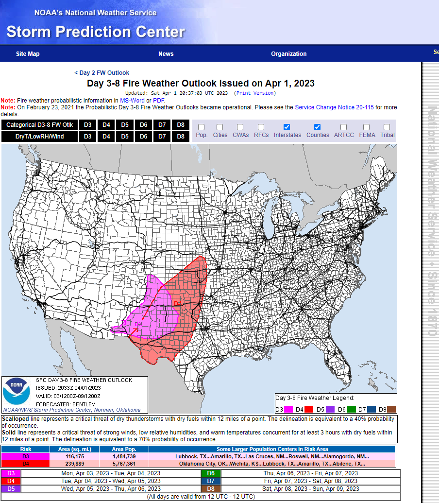
Critically Dangerous Fire Weather Conditions Today.

Critically Dangerous Fire Weather Conditions Monday.

Extremely Critically Dangerous Fire Weather Conditions Tuesday!


BULLETIN - EAS ACTIVATION REQUESTED
Fire Warning!
New Mexico EMERGENCY MANAGEMENT AGENCY Torrance County New Mexico
Relayed by National Weather Service Albuquerque NM
1228 PM MDT Sun Apr 2 2023

The following message is transmitted at the request of the New
Mexico EMERGENCY MANAGEMENT AGENCY Torrance County New Mexico.

A large grassfire spreading eastward immediately south of
Moriarty is threatening the community of Echo Ridge. County
officials have requested evacuation of this area to the Moriarty
Civic Center at: 202 South Broadway Moriarty, NM 87035. Residents
in need of urgent assistance can contact 911 or the Torrance
County Dispatch Center at 505-384-2705.
Extremely Critically Dangerous Fire Weather Conditions Forecast Tuesday!
The extremely dry conditions and the anticipated high winds have the potential produce Historic Fire Weather Conditions Tuesday! Any wildfire, forest fire, or grass fires will have the ability to rapidly spread and grow threatening life and properties Monday into Tuesday. Any potential fire would rapidly become large, destructive, and almost impossible to control in these high winds especially Monday afternoon into Tuesday night. Especially on Tuesday! Simply put please refrain from any type of outdoor activity that involves the use of sparks or flame today through Tuesday.
Any wildfire (pray they don't) that could possibly develop (from downed power lines and other sources) could potentially add to the dangerous travel conditions especially if they break out near highways or roadways. Dense smoke could combine with the blowing dust to add to the hazardous conditions.

Today.

Monday.

Tuesday.

NWS NDFD Forecast Low Temperatures.
Wednesday Morning.

Forecast high temperatures today and Monday are expected to be in the mid to upper 80's across the Southeastern Plains.
The Ruidoso, Capitan, Mescalero, Mayhill, Sacramento/Weed, Pinon, Timberon, and High Rolls/Mountain Park areas will see the mid 60's to near 70 today and Monday. The Cloudcroft and Sunspot areas will climb up into the low to mid 50's today and Monday.
A strong Pacific cold front will race across the state and region on Tuesday dropping our high temps down some 15-20 degrees from Sunday and Monday's readings. Come Wednesday morning most of New Mexico will experience a freeze with many areas a hard freeze.
There Are None So Blind As Those Who "Will - Not" To See...107.


Comments
Post a Comment
Your comments, questions, and feedback on this post/web page are welcome.