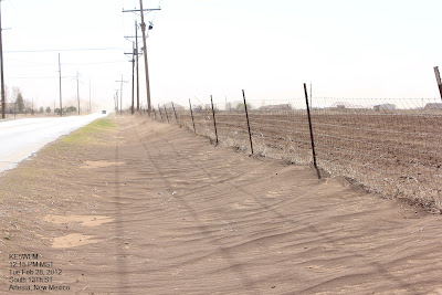
Video Of The Blinding Dust Storm In Artesia, NM Today.
Blog updated at 7:00 AM MST Wed Feb 29, 2012.
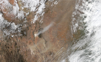
Sand Is Being Blown Northeastward From White Sands,
And The Brown Splotches Are Blowing Dust Over Mexico,
And Southeastern/Eastern New Mexico.
15-Vehicle Pile Up North Of Artesia Tuesday.
Blowing dirt is blamed for this multi-car crash on U.S. Highway 285 north of Artesia early Tuesday afternoon, according to N.M. State Police. Officers were first called to a two-car collision at around 12:30 p.m., but a total of 15 vehicles eventually crashed into the pileup, said NMSP Sgt. Lawrence Murray. Ten people were hospitalized - eight of those transported by ambulance - but none were seriously injured, police said. Article is courtesy of the Carlsbad Current Argus. http://www.currentargus.com/ci_20066513
As of 2:30 PM MST this afternoon some of the stronger wind gusts that already been recorded include-
WSMR - Salinas Peak (Sierra County) 107 mph
WSMR - Museum 83 mph
WSMR (EMRE) - NE of San Augustine Pass 79 mph
Sierra Blanca Regional Airport 74 mph
WSMR Main Post 70 mph
WSMR- Bldg 1830 69 mph
Artesia Airport AWOS 67 mph
Pine Springs - GNP 65 mph
San Augustine Pass - Organ Mtn's 63 mph
Guadalupe Pass ASOS 63 mph
Dunken Raws 60 mph
Bowl Raws - North Of Guadalupe Pk 59 mph
Tatum MesoNet 59 mph
2 SW Tatum 57 mph
Carlsbad Airport ASOS 56 mph
Dunken Raws 55 mph
Carlsbad - NMAQ 55 mph
Roswell Airport ASOS 53 mph
Hobbs Airport 53 mph
Caprock Raws 53 mph
Fort Stanton Raws 52 mph
Pinery Raws - Pine Springs 51 mph
Sacramento Peak - Sunspot 50 mph
Mescal Raws - Mescalero 50 mph
Wind Data Is Courtesy Of-
The Truth Is Stranger Than Fiction!
My Web Page Is Best Viewed With Google Chrome.


Comments
Post a Comment
Your comments, questions, and feedback on this post/web page are welcome.