Significant High Wind/Blowing Dust Event Today - Prepare For An Arctic Invasion!
Looking SW From C-Hill In Carlsbad.
Altocumulus Standing Lenticular Cards.
NWS NDFD Peak Wind Gust Forecast.
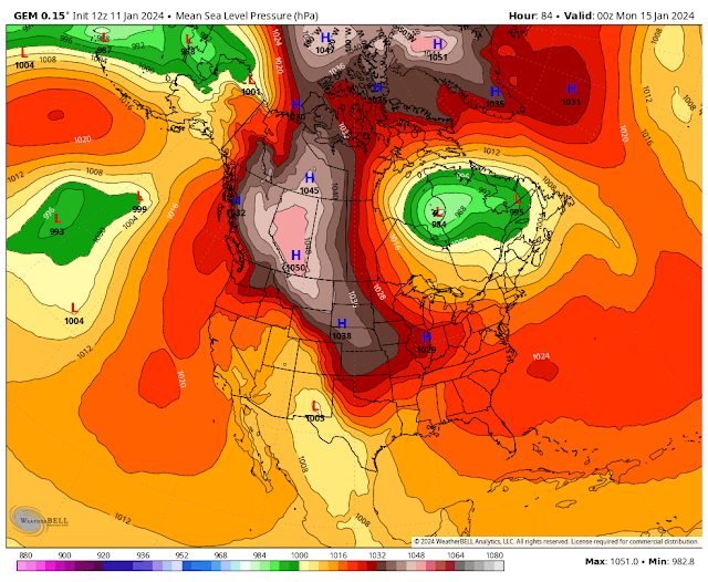
Mean Sea Level (MSP).
Sunday At 5 PM MST
At 11 AM MST Today.
At 5 AM MST Saturday.
High Wind/Blowing Dust Event Today!
Good morning everyone.
High Wind Warnings continue in effect today for Eddy, Lea, Culberson, Lincoln, and Otero Counties. As well as for southern New Mexico and much of West Texas. Wind Advisories continue in effect in other areas not under a High Wind Warning.
In the High Wind Warning areas west winds will become sustained (already are in some areas) at 35 to 50 mph with gusts near 65 to 75 mph. This includes the Artesia, Carlsbad, Hobbs, Ruidoso, Cloudcroft, Mayhill, Sacramento/Weed/ Pinon, Timberon, Mountain Park/High Roll, Mescalero, Silver Lake, Hondo, Capitan, and Alto areas.
West winds are forecast to become sustained at 40 to 65 mph with gusts near 95 mph in the Guadalupe Mountains. It's possible that Guadalupe Pass could be closed due to these hurricane force wind gusts and low visibility from the blinding dust storms.
A few higher gusts may occur in some areas. As of 10:10 AM MST some of the stronger gusts already noted this Thursday morning include:
Pinery Raws - Pine Springs in the Guadalupe Mtn's National Park 62 mph
White Sands Missile Range - Main Post 62 mph
3 Cross Ranch north of Dunken 61 mph
CBat Draw Raws - Carlsbad Caverns National Park Visitor Center 61 mmph
Carlsbad Airport ASOS 60 mph
Lincoln Portable Raws North of Mayhill 53 mph
Wind damage will occur in some locations especially in those areas that see peak gusts in excess of 65 mph! This includes: Damage to roofs, shingles, barns, sheds, road signs, billboards, power/utility lines/poles, and farmland irrigation sprinkler systems.
Widespread blowing dust will severely limit the visibility in many areas especially in our normally dust prone locations. Sudden drops in the visibility with little to no warning will occur during the stronger gusts. This includes: freshly plowed, cultivated or exposed/open farmlands, fields, lots, and highway construction sites. Blinding dust storms may bring travel to a halt in some locations.
There is also the potential for wildland, grasslands, and forest fires should the high winds down power lines. If this occurs thick smoke from these fires could add to visibility problems.
Thousands of people have moved into southeastern New Mexico and West Texas over the past 10 years or so. Many have no idea how bad our blind dust storms can be during these high wind events. Travel on area roads can not only be dangerous it can be deadly especially during these sudden brown outs caused by the higher wind gusts.
Brutal Arctic Invasion Still Coming!
The latest computer model forecasts available this morning continue to show an invasion from the arctic headed our way. The arctic front is forecast to enter northeastern New Mexico Saturday morning. There are model differences in whether or not this powerful cold front will get hung up in northeastern and eastern New Mexico on Saturday. It may slow its southward plunge somewhat until Sunday.
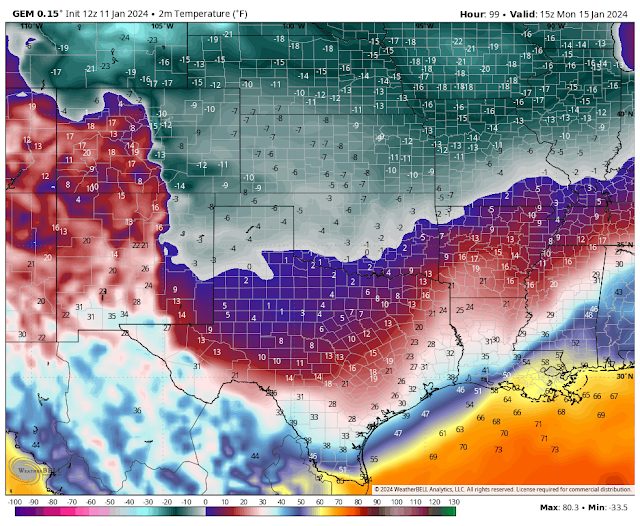
By Sunday at sunset most models agree that it will have beaten down the front down here in southeastern New Mexico. This morning's run of the Canadian (GEM) model still shows a nearly 70-degree temperature difference across the frontal boundary. Forecast temps at sunset Sunday (GEM model) show a temp of -6F in Clayton with a wind chill of -25F while the low to mid 60's are forecast for Eddy County.
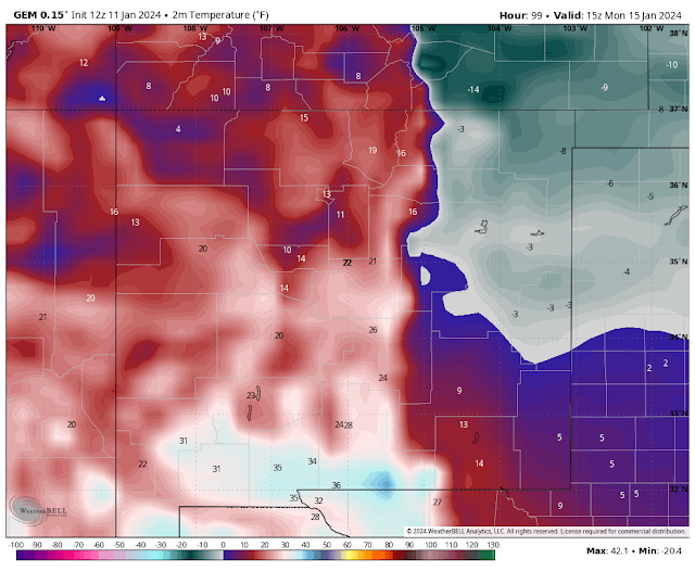
Again there are model differences in how long this brutally cold air mass stays entrenched across the eastern one half of the state. And to what extent it pushed westward through the northern-central-southern mountain chains, and how cold it gets west of the mountains.
For now it appears that much of the eastern half of the state will plunge below freezing Saturday (starting in NE NM first, then SE NM by Sunday afternoon or evening) and not get out of the deep freeze until perhaps Wednesday? This is still uncertain so expect to see changes in our local forecasts.
Wind Chill Advisories and Wind Chill Warnings will possibly be issued for areas along and east of the northern-central-southern mountains of New Mexico eastward into West Texas. As early as Saturday and into parts of the area into at least Tuesday I believe.
With wind chill temperatures cratering from 0F to as low as -25F/-30F across these areas do not underestimate the dangers of the impending cold weather outbreak. These readings will be life threatening to all caught outdoors without proper clothing and shelter.
These brutally cold temperatures will also have adverse effects on livestock, wildlife, and pets who remain outdoors. Now is the time to prepare in advance.
Oilfield activities will be greatly impacted by the brutally cold temperatures and wind chills also. Single digit low temperatures with some area dropping as low as -7F appear possible Monday morning east of the mountains. The coldest areas with the most severe wind chill temps will be across northeastern New Mexico and the Texas Panhandle, and southward down to at least a Clovis to Lubbock line. These areas may see lows below zero with wind chill temps in the -10F to -20F range.
Locally across the southeastern plains our low temps may drop down into the single digits to near zero in a few areas Monday morning. With wind chills ranging from near 0F to -20F.
More on all of this later. Visit my weather web page for additional info and all updates at:
There Are None So Blind As Those Who "Will - Not" To See...107.


Comments
Post a Comment
Your comments, questions, and feedback on this post/web page are welcome.