Beautiful Weather Until Friday - Next Winter Storm Friday Into Next Weekend.
North Of Capitan, NM.
Snow Drifts - State Hwy 246.
GFS 500 M (18,000' MSL) Forecast.
Valid At 5 PM MST Thursday, February 1, 2024.
Valid At 5 PM MST Saturday, February 3, 2024.
GFS 500 MB (18,000' MSL) Forecast.
GFS 500 MB (18,000' MSL) Forecast.
Valid At 5 PM MST Saturday, February 3, 2024.
GFS Mean Sea Level Pressure (MSLP) Forecast.
Valid At 5 PM MST Saturday, February 3, 2024.
GFS Total Snowfall Forecast.
Valid At 5 PM MST Saturday, February 3, 2024.
Carlsbad, New Mexico.
You can't hardly beat our weather as far as late January is concerned. That is if you love above normal temps and no precip. Enjoy because this will change come Friday into the upcoming weekend.
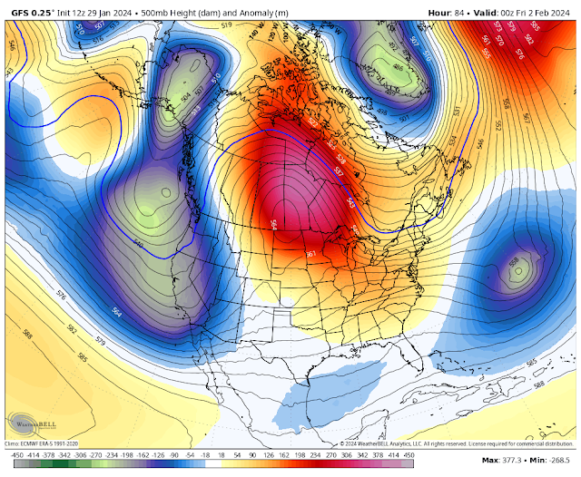
Our next strong winter storm will develop over the Western U.S. and Great Basin, then dive southeastward into the Desert Southwest late this week. This one has the potential to bring heavy mountain snows and lowland rains. Especially over western, northern, central, and northeastern New Mexico. Too early for trying to nail down the details as to how much rain and snow and exactly where yet.
Snow levels will start out fairly high over the western and northern halves of the State on Friday at around 8,500' lowering to valley floors Friday night into Saturday morning.
For the southeastern plains we may get a few rain showers Friday into Saturday. But with the current storm track trekking north of us once again I think our main weather story Friday into the weekend will be another high wind event. Early model forecasts are hinting at southwesterly wind gusts perhaps in the 55 to 65 mph range especially next Saturday. Another widespread dust storm will be possible especially if we get left out of the rain again. 😡
For the Sacramento and Capitan Mountains the setup looks pretty good for another round of moderate to heavy snowfall Friday into the weekend. Snow levels currently are forecast to start out around 9,000' on Friday dropping down to around 5,000' by next Saturday morning. Moderate to heavy snow looks possible above about 7,000'.
The exact details of where and what this next inbound winter storm will do are still fuzzy so I'll keep everyone updated later this week as the forecast models try and work out their differences and offer a better consensus of what will happen. Until then enjoy a tranquil week.
(Oct 1st, 2023 - Jan 29, 2024).
The Cloudcroft National Weather Service Climate Co-Op Station has recorded a seasonal snowfall total (Oct 1, 2023 to Jan 29, 2024) of 33.7". With 6" reported on the ground this morning. The report for Ruidoso is not yet available. So far this El Nino Modoki winter has been rather disappointing for us moisture-wise in the southeastern plains. And the Sacramento, Capitan, and Guadalupe Mountains.And there are signs that it may be weakening and headed back into a La Nina phase. As if it isn't dry enough here already.
Long Range Forecasts.
There Are None So Blind As Those Who "Will - Not" To See...107.


Comments
Post a Comment
Your comments, questions, and feedback on this post/web page are welcome.