

Multiple Days Of T-Storms/Heavy Rainfall - Flash Flood Threat Is High!

Ruidoso Downs, NM.
Ruidoso Downs Race Track.
Blog Post Updated At 10:30 AM MDT Friday, July 19, 2024.


(Valid Today Through 6 AM MDT Friday, July 19, 2024).

(Today Through 6 AM MDT Sunday, July 21, 2024).

Weather Prediction Center (WPC) 7-Day Total Rainfall Forecast.

(As Of 8 AM MDT Thursday, July 18, 2024).

(As Of 7 AM MDT Thursday, July 18, 2024).

(As Of 7 AM MDT Thursday, July 18, 2024).


(January 20th - July 17, 2024).

(January 20th - July 17, 2024).

Burn Scar Flash Flood Threat Is Very High Today Into The Weekend!
Widespread moderate rainfall with pockets of heavy rainfall fell over much of the state Wednesday afternoon and evening. But once again Eddy County as well as the southern one-quarter of the state, and far northwestern New Mexico were for the most part left out. Areas of heavy rainfall with totals generally in the 1" to 3" range fell over eastern New Mexico, parts of the northern mountains, and the central mountain chain. Lesser amounts in the light to moder category fell elsewhere.
Generally the forecast remains basically the same today into the weekend for most of the state...wash, rinse, and repeat. Daily rounds of showers and t-storms with locally heavy rainfall and flash flooding in some areas. Some t-storms may last overnight into the early morning hours in some areas. Nocturnal t-storms are fairly common in New Mexico in the summer months.
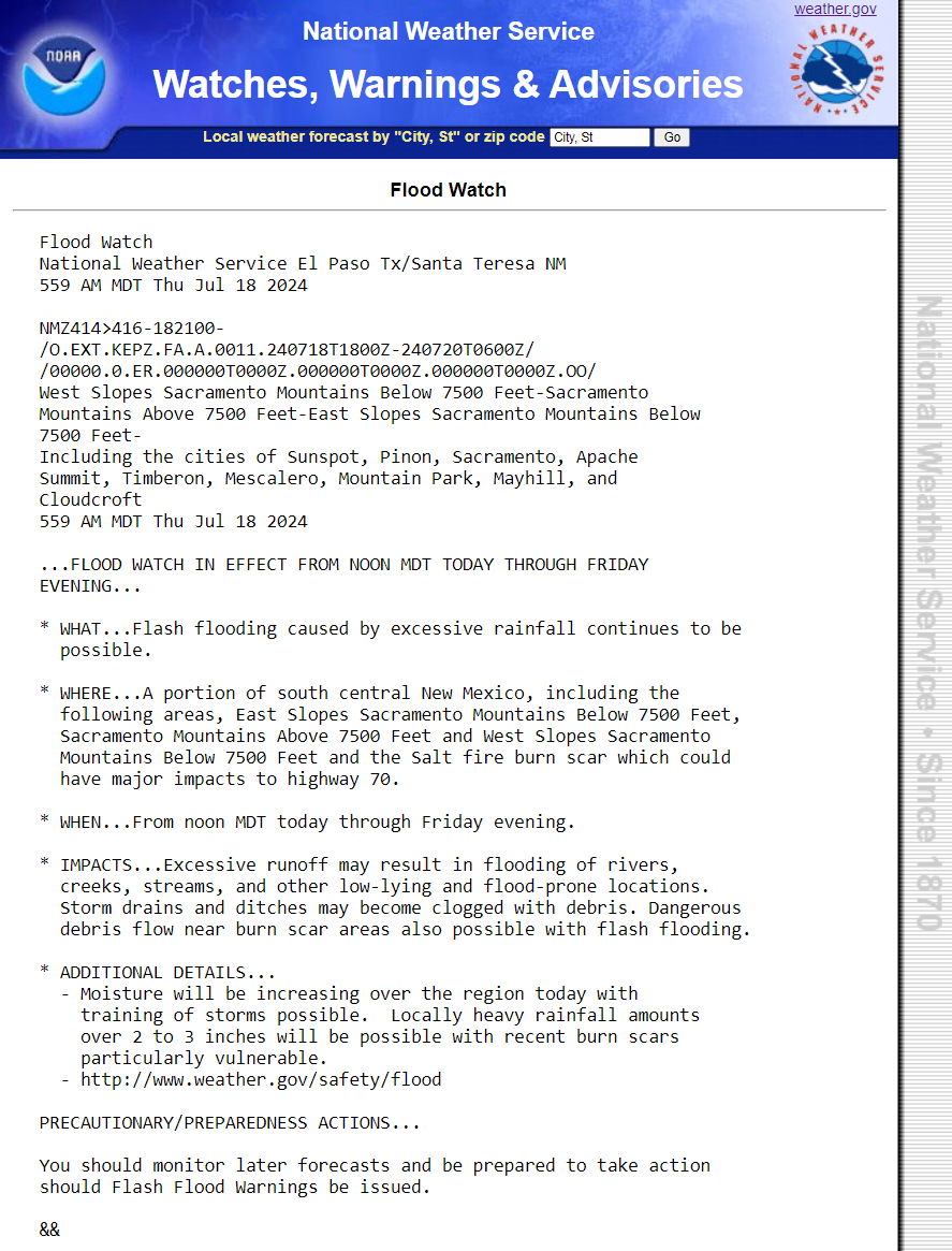
Concerns in the burn scar areas (see the attached t-storm matrix chart) for destructive or even catastrophic life threatening flash flooding remain very high today into the weekend. A Flood Watch covers much of the state and is valid through Friday in some locations. Additional Flood Watches will likely be issued by our local National Weather Service Offices into the weekend. The flash flood potential won't be limited just to the burn scar areas. Any area in the state that receives heavy to excessive t-storm rainfall today into the weekend will have the potential for flash flooding.
Remember: Turn Around - Don't Drown!
Much needed and for the most part welcome rainfall is forecast to fall today into the first of next week for most of the state. Forecast models are still showing some spots with storm totals in the 3" to 6" range by the weekend. It should be noted that the models sometimes underestimate rainfall totals in these types of setups. So do not be surprised if a few locations end up receiving more than what is forecast.
Ruidoso and surrounding areas are once again under the gun. They do not want nor need any additional heavy rainfall but it's going to happen. I can't stress how dangerous the situation is in and near that mountain community. Sadly the models are painting a bullseye on the Ruidoso area for very heavy to excessive rainfall from thunderstorms today into the first of next week. Complex's of thunderstorms and or training thunderstorms (one after another) will only make a very bad situation much worse very quickly. The flash flood threat will not be limited to daytime hours either as some storms could easily persist well into the night. All of the Sacrament mountains have a flash flood threat as well so Ruidoso won't be the only trouble spot into the weekend.
489
NOUS45 KABQ 181613
PNSABQ
NMZ201>241-190413-

Public Information Statement
National Weather Service Albuquerque NM
1013 AM MDT Thu Jul 18 2024

...HIGHEST WIND REPORTS...

Location                     Speed     Time/Date

...New Mexico...

...Cibola County...
El Morro 16 SSE (Malpais Lav 44 MPH    0525 PM 07/17
I-40 At Sr6                  40 MPH    0619 PM 07/17

...De Baca County...
Canyon Blanco                58 MPH    0650 PM 07/17
East Fort Sumner             46 MPH    0650 PM 07/17

...Guadalupe County...
Se Vaughn                    43 MPH    0630 PM 07/17

...Lincoln County...
Shist (WSMR)                 46 MPH    0710 PM 07/17
Nogal 5 NW                   42 MPH    0930 PM 07/17
Oscura Range Camp (WSMR)     41 MPH    0640 PM 07/17

...Los Alamos County...
Los Alamos 3 ESE (LANL)      40 MPH    1245 AM 07/18

...Roosevelt County...
Dora 2 SW                    45 MPH    0923 PM 07/17
Tolar 13 SE (Melrose Range)  40 MPH    0814 PM 07/17

...San Juan County...
Farmington Airport           40 MPH    1006 PM 07/17

...Sandoval County...
Placitas                     52 MPH    0815 PM 07/17
Coronado Swcd                41 MPH    0520 PM 07/17
Frijoles (Tower)             40 MPH    1008 PM 07/17

...Santa Fe County...
I-25 At La Bajada            40 MPH    0410 PM 07/17

...Socorro County...
Tower 6 (WSMR)               54 MPH    0955 PM 07/17
Little Burro (WSMR)          53 MPH    0655 PM 07/17
Mine (WSMR)                  47 MPH    0910 PM 07/17
Zumwalt Track (WSMR)         47 MPH    0935 PM 07/17
Stallion WIT (WSMR)          45 MPH    0840 PM 07/17
Sulf (WSMR)                  44 MPH    0825 PM 07/17
North Oscura Peak (WSMR)     41 MPH    1015 PM 07/17

...Taos County...
Arroyo Seco 3 SW             45 MPH    0430 PM 07/17
Taos Muni Airport            41 MPH    0401 PM 07/17

...Union County...
Clayton Muni Airpark         41 MPH    0324 PM 07/17

...PRECIPITATION REPORTS...

Location                     Amount    Time/Date

...New Mexico...

...Bernalillo County...
Tijeras 8.4 SSE              2.40 in   0700 AM 07/18
Ponderosa 1 WSW              2.17 in   0700 AM 07/18
Sedillo 1 ESE                1.36 in   0700 AM 07/18
1 SE Sedillo                 1.35 in   0753 PM 07/17
Miera 2 SW                   1.18 in   0600 AM 07/18
Ponderosa 2 WNW              1.10 in   0700 AM 07/18
Ponderosa 2 W                0.94 in   0956 AM 07/18
Albuquerque 7.6 E            0.73 in   0700 AM 07/18
Sedillo 1 S                  0.66 in   0700 AM 07/18
Cedar Crest 3.0 NNE          0.64 in   0700 AM 07/18
San Antonito 1 SSW           0.62 in   1000 AM 07/18
Sedillo 1 S                  0.61 in   1000 AM 07/18
Albuquerque 5.0 WSW          0.60 in   0500 AM 07/18
San Antonito 1 S             0.59 in   0955 AM 07/18
Albuquerque 8.0 ESE          0.58 in   0700 AM 07/18
Albuquerque 8.1 ESE          0.58 in   0700 AM 07/18
Albuquerque 8 ESE            0.54 in   1000 AM 07/18
3 NW Carnuel                 0.53 in   0722 PM 07/17
Ponderosa 2 NNW (Oak Flats)  0.53 in   0904 AM 07/18
Albuquerque 7.4 E            0.52 in   0700 AM 07/18
Sandia Park 3.7 ESE          0.52 in   0700 AM 07/18
Albuquerque 4.7 SSW          0.52 in   0800 AM 07/18
Albuquerque 7.8 ESE          0.52 in   0800 AM 07/18
Sandia Park 4.9 ESE          0.49 in   0700 AM 07/18
Carnuel 3 NW                 0.47 in   0955 AM 07/18
Sandia Park 3.6 ESE          0.46 in   0700 AM 07/18
Albuquerque 4.3 SSW          0.42 in   0700 AM 07/18
Edgewood 6.1 NW              0.41 in   0539 AM 07/18
3 SSW Rio Grande Nature Cent 0.40 in   0615 PM 07/17
Westside ABQ Comms Center    0.40 in   0955 AM 07/18
Albuquerque 7.8 ESE          0.39 in   0700 AM 07/18
Sedillo 2 ESE                0.39 in   0800 AM 07/18
Edgewood 6.3 NW              0.36 in   0700 AM 07/18
Albuquerque 8.1 ESE          0.34 in   0730 AM 07/18
Albuquerque NWS Office       0.32 in   0500 AM 07/18
South Valley 1.1 S           0.32 in   0700 AM 07/18
Albuquerque 6.6 E            0.28 in   0725 AM 07/18
Miera 2 ESE                  0.28 in   0800 AM 07/18
ALBUQUERQUE                  0.28 in   0959 AM 07/18
Edgewood 4.8 W               0.27 in   0700 AM 07/18
Albuquerque 6.5 SW           0.27 in   0700 AM 07/18
Albuquerque 7.3 W            0.27 in   0800 AM 07/18
Ponderosa 3 ENE              0.26 in   0700 AM 07/18
Albuquerque 6.8 W            0.25 in   0800 AM 07/18
Chilili 2 N                  0.24 in   0700 AM 07/18
Albuquerque Intl Sunport     0.24 in   0952 AM 07/18
Albuquerque 9.8 ESE          0.23 in   0700 AM 07/18
Tijeras 1.2 SW               0.21 in   0925 AM 07/18
Edgewood 4.4 W               0.20 in   0800 AM 07/18
Sandia Park 0.5 S            0.20 in   0900 AM 07/18
Albuquerque 4.7 W            0.19 in   0900 AM 07/18
Albuquerque 6.5 ESE          0.18 in   0700 AM 07/18
Sandia Heights 4.0 S         0.14 in   0700 AM 07/18
Albuquerque 7 E              0.14 in   0958 AM 07/18
Tijeras 0.4 SE               0.13 in   0700 AM 07/18
Albuquerque 6 ENE            0.13 in   0955 AM 07/18
Sedillo 1 WSW                0.12 in   0700 AM 07/18
3 SW Albuquerque             0.11 in   0627 PM 07/17
Albuquerque 6 W              0.11 in   0958 AM 07/18
Albuquerque 8.0 ESE          0.10 in   0700 AM 07/18
Albuquerque 4 NE             0.10 in   0700 AM 07/18
Albuquerque 8.7 SE           0.10 in   0700 AM 07/18
Albuquerque 4 NE             0.10 in   0954 AM 07/18

...Catron County...
Datil 11 NNE (Datil)         0.65 in   0911 AM 07/18
Luna 1 ENE (Luna)            0.52 in   0907 AM 07/18
Alma                         0.42 in   0651 PM 07/17
Mogollon 1 WSW (Mogollon)    0.29 in   0913 AM 07/18
3.0 W Glenwood (JE-FULLER)   0.24 in   1043 PM 07/17
14.3 S Luna (JE-FULLER)      0.20 in   0256 AM 07/18
Reserve 1 WSW                0.14 in   0908 AM 07/18
Reserve 1 W                  0.11 in   0915 AM 07/18

...Chaves County...
Roswell 5.5 E                1.00 in   0700 AM 07/18
Roswell No. 1 Portable       0.53 in   0940 AM 07/18
Roswell 0.3 SSW              0.50 in   0700 AM 07/18
Mesa 4 SW                    0.35 in   0800 AM 07/18
Roswell 6.0 NNW              0.32 in   0700 AM 07/18
Roswell 3.4 NNE              0.27 in   0700 AM 07/18
Bitter Lake WL Refuge 14 NNE 0.26 in   0937 AM 07/18
Roswell 5.1 N                0.25 in   0800 AM 07/18
Roswell Air Center           0.22 in   0951 AM 07/18
Roswell 25.3 NW              0.15 in   0700 AM 07/18
Mesa 11 NW                   0.15 in   0700 AM 07/18

...Cibola County...
El Morro 16 SSE (Malpais Lav 0.93 in   0925 AM 07/18
San Mateo 6 SSW (Grants)     0.70 in   0916 AM 07/18
Pine Hill 14 SSE             0.69 in   0934 AM 07/18
19 SW Acoma Pueblo (Brushy M 0.38 in   0949 AM 07/18
Grants 1.6 NE                0.23 in   0700 AM 07/18
Ramah 3.1 ENE                0.14 in   0600 AM 07/18
Pine Hill 7 S                0.10 in   1000 AM 07/18

...Colfax County...
Angel Fire 4.1 NNW           0.44 in   0700 AM 07/18
Angel Fire Airport           0.34 in   0935 AM 07/18
Miami 1 WSW                  0.28 in   0700 AM 07/18
Ute Park 3 N (Cimarron)      0.13 in   0909 AM 07/18

...De Baca County...
Fort Sumner 12 NW            0.24 in   0800 AM 07/18

...Guadalupe County...
Santa Rosa Airport           0.84 in   0855 AM 07/18
Fort Sumner 17.0 NW          0.42 in   0800 AM 07/18
Santa Rosa 12.1 SE           0.33 in   0700 AM 07/18

...Harding County...
3 ENE Mosquero               0.40 in   0700 PM 07/17

...Lincoln County...
Ruidoso 5.6 NNE              1.28 in   0700 AM 07/18
Capitan 1.3 WSW              1.05 in   0745 AM 07/18
Alto 4.8 NE                  0.95 in   0700 AM 07/18
Capitan 5.5 NE               0.79 in   0700 AM 07/18
Ruidoso 2 SSW                0.73 in   0700 AM 07/18
Alto 0.3 N                   0.73 in   0700 AM 07/18
Nogal 4.6 SSE                0.73 in   0700 AM 07/18
Capitan 4.3 WSW              0.72 in   0700 AM 07/18
Alto 1 E                     0.67 in   0955 AM 07/18
Ruidoso 1 NNW (Smokey Bear)  0.60 in   0900 AM 07/18
Lincoln Portable No. 2       0.50 in   0937 AM 07/18
Carrizozo 1 WNW              0.50 in   0946 AM 07/18
Ruidoso 3.2 SW               0.47 in   0800 AM 07/18
Lincoln 1.4 ESE              0.46 in   0700 AM 07/18
Nogal 5 NW                   0.45 in   1000 AM 07/18
Alto 7.4 W                   0.42 in   0700 AM 07/18
5.4 SW Bonito Lake           0.35 in   0950 AM 07/18
Roswell No. 2 Portable       0.16 in   0920 AM 07/18

...Los Alamos County...
Los Alamos 2.5 WSW           1.14 in   0800 AM 07/18
Los Alamos 1.8 WNW           0.73 in   0822 AM 07/18
Los Alamos 2 E               0.43 in   0955 AM 07/18
Los Alamos Airport           0.40 in   0955 AM 07/18
Los Alamos 2 ENE             0.38 in   0957 AM 07/18
Los Alamos 1 NNE             0.34 in   1000 AM 07/18
Los Alamos 6.9 SSE           0.17 in   0700 AM 07/18
White Rock                   0.17 in   0800 AM 07/18
Los Alamos 7.1 SE            0.15 in   0800 AM 07/18
White Rock                   0.15 in   0958 AM 07/18
White Rock 1.5 NNE           0.12 in   0800 AM 07/18

...McKinley County...
Rio Puerco Qd No. 1          0.49 in   0903 AM 07/18

...Mora County...
Chacon 2.1 ENE               0.74 in   0700 AM 07/18
Bartley                      0.35 in   0904 AM 07/18
Wagon Mound 3.2 WNW          0.10 in   0700 AM 07/18

...Quay County...
McAlister 3.7 WNW            0.67 in   0700 AM 07/18
House 0.1 S                  0.63 in   0700 AM 07/18

...Rio Arriba County...
Truchas 3 ENE (Truchas)      0.35 in   0911 AM 07/18
6.9 ESE Cuba (SNOTEL)        0.30 in   0900 AM 07/18
Truchas 1.4 ESE              0.28 in   0700 AM 07/18
Chama 6.6 SSE                0.21 in   0500 AM 07/18
Chama 1.0 N                  0.20 in   0800 AM 07/18
Chama 2 N                    0.18 in   0900 AM 07/18
Alcalde                      0.12 in   0730 AM 07/18
Gallina 2.0 W                0.10 in   0700 AM 07/18
Espanola 4 S                 0.10 in   0955 AM 07/18

...Roosevelt County...
Portales 5.1 SSW             1.87 in   0700 AM 07/18
Elida 5.7 W                  1.20 in   0700 AM 07/18
Elida 9.1 S                  0.97 in   0700 AM 07/18
Portales 2.0 N               0.88 in   0702 AM 07/18
Causey 13.4 SW               0.46 in   0700 AM 07/18
Milnesand                    0.38 in   0700 AM 07/18
12 SE Tolar                  0.27 in   0955 AM 07/18
Tolar 13 SE (Melrose Range)  0.20 in   0914 AM 07/18
Tolar 13 SE (Melrose)        0.12 in   0914 AM 07/18

...San Juan County...
Aztec 5.2 E                  0.10 in   0500 AM 07/18

...San Miguel County...
PECOS                        1.14 in   1000 AM 07/18
Rowe 2.7 NNW                 0.77 in   0700 AM 07/18
Lower Colonias 5 E (Pecos)   0.38 in   0914 AM 07/18
Ilfeld 0.7 NE                0.36 in   0800 AM 07/18
Rociada                      0.17 in   0945 AM 07/18
Las Vegas                    0.14 in   0700 AM 07/18
San Pablo 2 E                0.14 in   0700 AM 07/18

...Sandoval County...
Placitas 0.3 SSE             0.66 in   0700 AM 07/18
Cuba                         0.61 in   1000 AM 07/18
Nmspa_port1                  0.60 in   0953 AM 07/18
Jemez Pueblo 5.7 NNW         0.51 in   0630 AM 07/18
Los Posos (DRI)              0.46 in   0900 AM 07/18
Placitas 2.6 W               0.42 in   0700 AM 07/18
CUBA                         0.37 in   0956 AM 07/18
Bernalillo 3 E               0.36 in   0945 AM 07/18
Cuba 2.1 NNW                 0.35 in   0700 AM 07/18
Jemez Springs 6.6 ENE        0.30 in   0700 AM 07/18
San Antonio (DRI)            0.29 in   0900 AM 07/18
Bernalillo 1.8 NE            0.27 in   0700 AM 07/18
Redondo (DRI)                0.21 in   0900 AM 07/18
Jemez Springs (DRI)          0.21 in   0900 AM 07/18
La Cueva 2 SSE (Jemez)       0.21 in   0908 AM 07/18
Placitas 2.0 E               0.20 in   0700 AM 07/18
Bernalillo 0.9 SSE           0.20 in   0700 AM 07/18
Placitas 1.6 ENE             0.17 in   0700 AM 07/18
Jemez Springs 7.9 NNE        0.15 in   0800 AM 07/18
Cebollita Spring (DRI)       0.15 in   0900 AM 07/18
Frijoles (Tower)             0.15 in   0908 AM 07/18
Rio Rancho 5.4 NNE           0.14 in   0645 AM 07/18
Bernalillo 0.9 WSW           0.14 in   0800 AM 07/18
VALLES CALDERA LOS ALAMOS 13 0.12 in   0915 AM 07/18

...Santa Fe County...
Glorieta 2.4 E               1.85 in   0700 AM 07/18
Glorieta                     0.90 in   0958 AM 07/18
Santa Fe 3.2 WNW             0.75 in   0800 AM 07/18
Santa Fe 3.3 WNW             0.72 in   0700 AM 07/18
Santa Fe 0.7 ESE             0.62 in   0700 AM 07/18
Santa Fe                     0.62 in   1000 AM 07/18
Santa Fe 3.6 WNW             0.55 in   0700 AM 07/18
Santa Fe 1.6 WSW             0.51 in   1159 PM 07/17
Santa Fe 0.9 WNW             0.51 in   0700 AM 07/18
Santa Fe 4.6 NW              0.49 in   0700 AM 07/18
Santa Fe 0.7 E               0.48 in   0700 AM 07/18
Santa Fe 1.5 W               0.47 in   0811 AM 07/18
Santa Fe 4.1 WNW             0.45 in   0700 AM 07/18
Santa Fe 0.3 NNE             0.44 in   0800 AM 07/18
Santa Fe                     0.44 in   1000 AM 07/18
Santa Fe 0.6 ENE             0.43 in   0730 AM 07/18
Tesuque                      0.42 in   0946 AM 07/18
Santa Fe 3 NW                0.42 in   0947 AM 07/18
Santa Fe 7.7 WNW             0.41 in   0700 AM 07/18
Santa Fe                     0.35 in   0700 AM 07/18
Tesuque                      0.35 in   0939 AM 07/18
Santa Fe 4 NW                0.34 in   0955 AM 07/18
Agua Fria 1 N                0.34 in   0955 AM 07/18
Edgewood 2 N                 0.30 in   1000 AM 07/18
Santa Fe 1.1 N               0.29 in   0700 AM 07/18
Santa Fe 1.1 NNW             0.29 in   0700 AM 07/18
Santa Fe 1 WNW               0.28 in   0958 AM 07/18
Edgewood 2.7 W               0.25 in   0700 AM 07/18
2 N Santa Fe                 0.23 in   0700 AM 07/18
Santa Fe 5 E (Santa Fe Water 0.18 in   0953 AM 07/18
Santa Fe 2 SSE               0.18 in   0955 AM 07/18
Santa Fe 3 ENE               0.16 in   0957 AM 07/18
Santa Fe 4 ENE               0.16 in   1000 AM 07/18
Santa Fe 3.7 NE              0.13 in   0800 AM 07/18
Tesuque 1 W                  0.13 in   0953 AM 07/18
Santa Fe 3.4 NE              0.12 in   0700 AM 07/18
Glorieta 6 WNW               0.12 in   0945 AM 07/18
Edgewood                     0.12 in   0959 AM 07/18
Pojoaque 1.0 E               0.10 in   0700 AM 07/18

...Socorro County...
Abo 10 SW                    0.33 in   0700 AM 07/18
Socorro Airport              0.21 in   0955 AM 07/18
Polvadera 0.5 S              0.20 in   0700 AM 07/18
Bosque Del Apache 1 NNE (Bos 0.18 in   0950 AM 07/18
Polvadera                    0.14 in   0600 AM 07/18
Socorro 1.3 E                0.11 in   0700 AM 07/18
Contreras 1 ESE (Sevilleta)  0.11 in   0911 AM 07/18

...Taos County...
San Cristobal 0.1 NE         0.27 in   0700 AM 07/18
Valdez 1 NNW                 0.16 in   0959 AM 07/18
Taos 4.3 NNW                 0.11 in   1159 PM 07/17
Costilla 0.1 SE              0.11 in   0700 AM 07/18
Arroyo Hondo 2.5 E           0.10 in   0700 AM 07/18
Taos Pueblo Raws             0.10 in   0913 AM 07/18
Arroyo Seco 3 SW             0.10 in   1000 AM 07/18

...Torrance County...
Estancia 10.6 WNW            0.64 in   0700 AM 07/18
Estancia 9.4 NW              0.35 in   0700 AM 07/18
Mountainair 4.8 WNW          0.30 in   0800 AM 07/18
Estancia 7 SSW               0.28 in   0945 AM 07/18
Edgewood 7.0 SSW             0.23 in   0700 AM 07/18
Estancia 2 WSW               0.23 in   0951 AM 07/18
Mountainair 8 NW             0.20 in   0700 AM 07/18
Estancia 6.4 WSW             0.18 in   0700 AM 07/18
Mountainair 4.2 WSW          0.18 in   0700 AM 07/18
Abo 3 N                      0.15 in   0945 AM 07/18
Clines Corners 1 SSE         0.13 in   0953 AM 07/18
Edgewood 3.2 S               0.10 in   0600 AM 07/18

...Union County...
Clayton 1.1 W                1.55 in   0900 AM 07/18
Clayton 12.4 SSW             1.25 in   0700 AM 07/18
Clayton 13.7 N               1.25 in   0700 AM 07/18
Clayton 2.3 ENE              1.16 in   0700 AM 07/18
Clayton Muni Airpark         1.13 in   0955 AM 07/18
Grenville 7.2 ENE            0.78 in   0616 AM 07/18
Clayton 14.6 SSW             0.65 in   0700 AM 07/18
Amistad 8.5 WSW              0.35 in   0700 AM 07/18
Amistad 7.7 SW               0.26 in   0700 AM 07/18

...Valencia County...
Peralta 1 WSW                0.86 in   0945 AM 07/18
Peralta 0.6 S                0.77 in   0700 AM 07/18
Los Lunas 3.5 E              0.64 in   0700 AM 07/18
Rio Communities 0.5 N        0.55 in   0730 AM 07/18
Belen 1.2 WSW                0.49 in   0700 AM 07/18
Belen 1.0 NNE                0.49 in   0823 AM 07/18
Los Lunas 3.7 SSE            0.48 in   0800 AM 07/18
Belen 3.3 SSE                0.46 in   0700 AM 07/18
Los Lunas 4.1 SE             0.38 in   0600 AM 07/18
Valencia 1 NNE               0.36 in   1000 AM 07/18
Los Lunas                    0.35 in   0955 AM 07/18
Los Lunas 3.3 ESE            0.34 in   0800 AM 07/18
Belen 3.2 S                  0.30 in   0700 AM 07/18
Los Lunas 3 SSW              0.30 in   0730 AM 07/18
Bosque Farms 0.6 N           0.27 in   0700 AM 07/18
Tome 2 NNW                   0.24 in   0955 AM 07/18
Meadow Lake                  0.23 in   0800 AM 07/18
Los Lunas 6.9 SSE            0.19 in   0800 AM 07/18
Belen Regional Airport       0.16 in   0955 AM 07/18
&&
There Are None So Blind As Those Who "Will - Not" To See...107.


Comments
Post a Comment
Your comments, questions, and feedback on this post/web page are welcome.