Cold Front Drops Temps Much Below Normal Monday & T-Storms Return.
Artesia, New Mexico.
Sinclair/Navajo Refinery.
Outflow winds from a line of t-storms east and southeast of Artesia on Wednesday, June 26th produced areas of blowing dust that briefly cut the visibility down to near zero. Also, see my blog post on July 1st: Seven Rivers, NM Wet Microburst & Hagerman Landspout Tornado- June 26, 2024.
Much Cooler Monday With Hit & Miss T-Storms & Normal Temps Next Week.
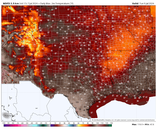
An unusually strong backdoor cold front (for the first week of July) will slide south amd west into the southeastern plains late tonight into Monday morning. After topping out with high temps this afternoon generally around 105F, our highs on Monday behind the front will only be in the upper 70's to the mid 80's.
Hit-and-miss t-storms will dot the landscape next week with the best chances for rainfall over and near the mountains. Any one storm will have the potential to drop heavy rainfall and produce localized flash flooding especially over and near the burn scars in the mountains. Tuesday into Wednesday evening will have the highest chances for this activity.
Overall a fairly typical summertime monsoonal pattern is forecast next week for the local area. Our high temps in southeastern New Mexico will be closer to normal than of late. With a chance of afternoon and evening hit-and-miss storms. No drought busters are on the way but it is a welcome change from the relentless heat we've had so far this summer.
It has been another hot summer so far but it could always be worse trust me. Consider Death Valley, California where the official temperature at the Visitors Center at 11 AM PDT (Noon MDT) was already 111F after a morning low of 94F. Their high temp on Saturday was 128F. Forecast highs today into next Wednesday will flirt with 130F.
Today.
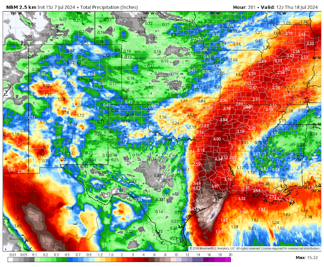
Thursday.
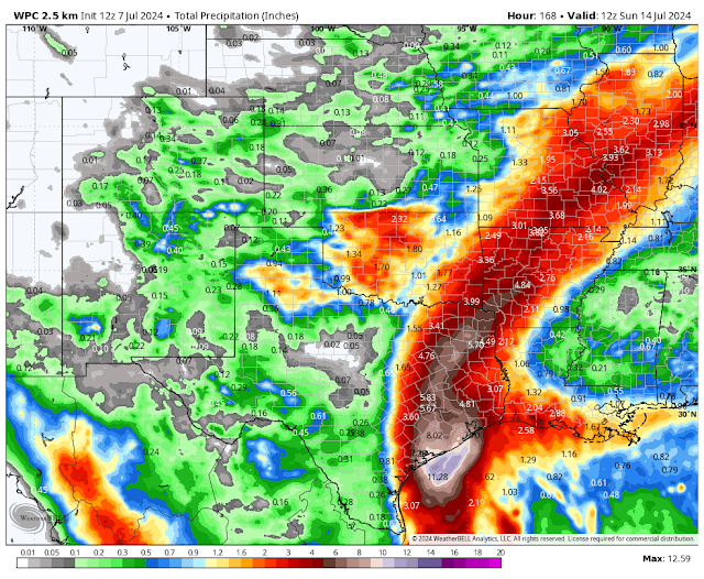
WPC 7-Day Total Rainfall Forecast.
As Of 7 AM MDT Saturday, July 6, 2024.
At 11:36 AM MDT Sunday, July 7, 2024.
548
WTNT32 KNHC 071447
TCPAT2

BULLETIN
Tropical Storm Beryl Advisory Number  36
NWS National Hurricane Center Miami FL       AL022024
1000 AM CDT Sun Jul 07 2024

...BERYL BECOMING BETTER ORGANIZED AND FORECAST TO BECOME A
HURRICANE BEFORE LANDFALL...
...PREPARATIONS SHOULD BE RUSHED TO COMPLETION...


SUMMARY OF 1000 AM CDT...1500 UTC...INFORMATION
-----------------------------------------------
LOCATION...25.9N 95.1W
ABOUT 195 MI...315 KM SSE OF MATAGORDA TEXAS
ABOUT 195 MI...310 KM SE OF CORPUS CHRISTI TEXAS
MAXIMUM SUSTAINED WINDS...65 MPH...100 KM/H
PRESENT MOVEMENT...NW OR 325 DEGREES AT 10 MPH...17 KM/H
MINIMUM CENTRAL PRESSURE...992 MB...29.29 INCHES


WATCHES AND WARNINGS
--------------------
CHANGES WITH THIS ADVISORY:

A Storm Surge Warning has issued for the coast of Texas from High
Island to Sabine Pass.

The Storm Surge Watch has been discontinued from the mouth of the
Rio Grande to Baffin Bay, Texas.

The Tropical Storm Watch for the Texas coast east of High Island to
Sabine Pass has been upgraded to a Tropical Storm Warning.

The Hurricane Watch for the Texas coast south of Baffin Bay to
the mouth of the Rio Grande has been discontinued.

SUMMARY OF WATCHES AND WARNINGS IN EFFECT:

A Storm Surge Warning is in effect for...
* North Entrance of the Padre Island National Seashore to Sabine
Pass, including Corpus Christi Bay, Matagorda Bay, and Galveston
Bay

A Hurricane Warning is in effect for...
* The Texas coast from Baffin Bay northward to San Luis Pass

A Hurricane Watch is in effect for...
* The Texas coast north of San Luis Pass to Galveston Island

A Tropical Storm Warning is in effect for...
* The Texas coast south of Baffin Bay to the mouth of the Rio
Grande
* The Texas coast north of San Luis Pass to Sabine Pass
* The northeastern coast of mainland Mexico from Barra el
Mezquital to the mouth of the Rio Grande River

A Storm Surge Watch is in effect for...
* North of Baffin Bay, Texas to North Entrance of the Padre Island
National Seashore

A Hurricane Warning means that hurricane conditions are expected
somewhere within the warning area.  Preparations to protect life
and property should be rushed to completion.

A Hurricane Watch means that hurricane conditions are possible
within the watch area.

A Tropical Storm Warning means that tropical storm conditions are
expected within the warning area.

A Storm Surge Warning means there is a danger of life-threatening
inundation, from rising water moving inland from the coastline,
during the next 36 hours in the indicated locations. For a
depiction of areas at risk, please see the National Weather
Service Storm Surge Watch/Warning Graphic, available at
hurricanes.gov.  This is a life-threatening situation.  Persons
located within these areas should take all necessary actions to
protect life and property from rising water and the potential for
other dangerous conditions.  Promptly follow evacuation and other
instructions from local officials.

A Storm Surge Watch means there is a possibility of life-
threatening inundation, from rising water moving inland from the
coastline.

Interests elsewhere along the northwestern Gulf of Mexico coast
should closely monitor the progress of Beryl.

For storm information specific to your area in the United
States, including possible inland watches and warnings, please
monitor products issued by your local National Weather Service
forecast office. For storm information specific to your area
outside of the United States, please monitor products issued by
your national meteorological service.


DISCUSSION AND OUTLOOK
----------------------
At 1000 AM CDT (1500 UTC), the center of Tropical Storm Beryl was
located near latitude 25.9 North, longitude 95.1 West. Beryl is
moving toward the northwest near 10 mph (17 km/h). A turn toward
the north-northwest is expected this afternoon, with a turn toward
the north on Monday. On the forecast track, the center of Beryl is
expected to make landfall on the middle Texas coast early Monday.
Beryl is forecast to turn northeastward and move farther inland
over eastern Texas and Arkansas late Monday and Tuesday.

Maximum sustained winds have increased to near 65 mph (100 km/h)
with higher gusts.  Steady strengthening is expected, and Beryl is
forecast to become a hurricane again later today.  Continued
strengthening is expected overnight before Beryl reaches the Texas
coast.

Tropical-storm-force winds extend outward up to 125 miles (205 km)
from the center.

The estimated minimum central pressure is 992 mb (29.29 inches).


HAZARDS AFFECTING LAND
----------------------
Key messages for Beryl can be found in the Tropical Cyclone
Discussion under AWIPS header MIATCDAT2, WMO header WTNT42 KNHC,
and on the NHC website at hurricanes.gov/text/MIATCDAT2.shtml.

WIND: Hurricane conditions are expected in the hurricane warning
area by early Monday.  Winds are first expected to reach tropical
storm strength by late today, making outdoor preparations difficult
or dangerous.

Hurricane conditions are possible in the hurricane watch areas by
early Monday, with tropical storm conditions beginning by tonight.

Tropical storm conditions are expected in the tropical storm
warning areas in Texas and northeastern Mexico by tonight.

STORM SURGE: The combination of storm surge and tide will cause
normally dry areas near the coast to be flooded by rising waters
moving inland from the shoreline.  The water could reach the
following heights above ground somewhere in the indicated areas if
the peak surge occurs at the time of high tide...

Mesquite Bay, TX to San Luis Pass, TX...4-6 ft
Matagorda Bay...4-6 ft
San Luis Pass, TX to Sabine Pass, TX... 3-5 ft
N Entrance Padre Island NS, TX to Mesquite Bay, TX...3-5 ft
Galveston Bay...3-5 ft

The deepest water will occur along the immediate coast near and to
the right of the center, where the surge will be accompanied by
large and destructive waves. Surge-related flooding depends on the
relative timing of the surge and the tidal cycle, and can vary
greatly over short distances.  For information specific to your
area, please see products issued by your local National Weather
Service forecast office.

For a complete depiction of areas at risk of storm surge inundation,
please see the National Weather Service Peak Storm Surge Graphic,
available at hurricanes.gov/graphics_at2.shtml?peakSurge.

RAINFALL:  Heavy rainfall of 5 to 10 inches with localized amounts
of 15 inches is expected across portions of the middle and upper
Texas Gulf Coast and eastern Texas beginning today through Monday
night. This rainfall will produce areas of flash and urban flooding,
some of which may be locally considerable. Minor to isolated
moderate river flooding is also expected.

For a complete depiction of forecast rainfall and flash flooding
associated with Tropical Storm Beryl, please see the National
Weather Service Storm Total Rainfall Graphic, available at
hurricanes.gov/graphics_at2.shtml?rainqpf and the Flash Flood Risk
graphic at hurricanes.gov/graphics_at2.shtml?ero

TORNADOES: A few tornadoes could occur along the middle and upper
Texas Coast through tonight, and across eastern Texas and western
Louisiana on Monday.

SURF:  Swells generated by Beryl are expected to affect eastern
Mexico and much of the Gulf Coast of the U.S. during the next day
or two.  These swells are expected to cause life-threatening
surf and rip current conditions. Please consult products from your
local weather office.


NEXT ADVISORY
-------------
Next intermediate advisory at 100 PM CDT.
Next complete advisory at 400 PM CDT.

$$
Forecaster Blake
There Are None So Blind As Those Who "Will - Not" To See...107.


Comments
Post a Comment
Your comments, questions, and feedback on this post/web page are welcome.