Chance For Rain Into Tonight - Mixing With Snow Late.
Click On The Maps To Enlarge them.
Blog updated at 3:34 PM MST.
Blog updated at 3:34 PM MST.
Northern Sacramento Mtn's
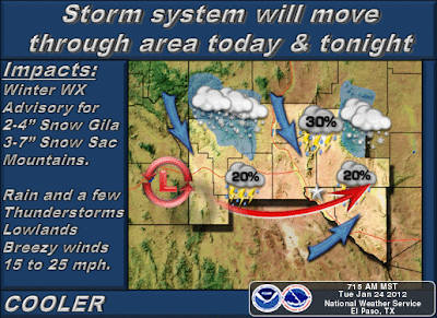
Valid 11 AM MST Today - 8 AM MST Wed.
2"- 4" Snowfall Below 7,500'
4"-7" Above 7,500'.
Southern Sacramento Mtn's
Valid 11 AM MST Today - 11 AM MST Wed.
3"- 7" Snowfall Above 6,500'.
Winter Weather Advisory!
(Guadalupe Mtn's)
Valid 11 PM MST Tonight - 5 PM MST Wednesday
A Rain/Snow Mix Tonight Above 6,000'.
Rain Changing Over To Snow After Midnight
In The Guadalupe Mtn's. 2" - 4" Of Snow
Possible In The Guadalupe Mtn's By Wed.
Special Weather Statement!
(Eddy-Culberson Counties.)
Rain/Snow/Sleet Mix Across Eddy/Culberson
Counties Late Tonight Into Wed Morning. Isolated
T-Storms Possible Which Will Enhance The Wintry
Precipitation.
At sunrise this morning our next weather maker was located over southern Arizona. This mid-upper level disturbance continues to sag southward early this morning, and is forecast to form a closed low later today. It is then forecast to crawl slowly east or southeastward along the New Mexico/Mexico border tonight,and by tomorrow morning it is forecast to be located over or near southeastern New Mexico.
I am a little concerned that this next inbound mid-upper level storm is going to end up being a little stronger than forecast, and it appears to have shifted a little further to the west than what the models have been forecasting. If this storm digs southward into northern Mexico and stalls, then our chances for seeing accumulating snowfall across parts of SE NM could increase later tonight into tomorrow morning. This has been a winter of surprises for SE NM and W TX, so I would not be shocked to see some of us get some snow on the ground out of this storm. I think that this will be especially over and near the Guadalupe and Sacramento Mountains. Just my two cents worth of thinking on this storm folks.
Cloudy skies will dominate the area today with our afternoon high temps expected to be in the upper 50's to the mid 60's. A Pacific cold front will move into the area tonight. Our overnight lows are forecast to drop down to near freezing by sunrise tomorrow morning. Wednesday will be cooler with highs ranging from 45 - 50.
Rain showers and higher mountain snow showers are increasing this morning over the western one-third of the state. These will continue to increase in aerial coverage and intensity throughout the day. By this afternoon scattered rain showers will move into our local area and continue into tonight. Our chances of seeing measurable rain and snowfall currently stand at around 40% - 50%.
An isolated thunderstorm or two is not out of the questions across SE NM. There is a better chance of this happening across parts of West Texas in the Permian Basin and Lower Tran Pecos areas. A few of these t-storms may approach severe levels and produce large hail and strong wind gusts.
Snow is forecast to mix in with the rain over parts of SE NM late tonight into tomorrow morning. However, current thinking from our local National Weather Service Offices is that the airmass will not be quite be cold enough to support accumulating snowfall amounts across the lower elevations of SE NM and W TX.
Snow levels today across the Sacramento Mountains are forecast to range from around 6,000' to 6,500' MSL. Snow levels are forecast to drop down to around 5,000 MSL over the western slopes of the Sacramento's by tomorrow morning. Accumulating snowfall will occur today above 6,500' MSL.
Snowfall totals across the Sacramento Mountains are forecast to generally be in the 3" - 7" range by midday Wednesday. A few of the higher peaks and east facing slopes may see a little more than this.
The Truth Is Stranger Than Fiction!
My Web Page Is Best Viewed With Google Chrome.


Comments
Post a Comment
Your comments, questions, and feedback on this post/web page are welcome.