More Record Warmth & Breezy - Windy Today.
Guadalupe Mtn's - Continues Until 8 PM MST Tonight.
West Winds 35-45G60 MPH.
Lincoln County.
Continues In Effect Until 8 PM MST Today.
West Winds 35G50 MPH.
SE NM & W TX.
Valid From 11 AM - 5 PM MST.
SW-W Winds 20-30G35+ MPH.
Critically Dangerous Fire Weather Conditions.
Record High Temps Possible Again Today.
As of 5 AM MST this morning, the Roswell Airport was reporting a temp of 32F with calm winds. Meanwhile, at the Carlsbad Airport the temp was 61F with a WSW wind at 23 mph gusting to 28 mph. This temperature difference is a direct result of those warm dry downslopping southwesterly winds that are occurring across the Guadalupe Mountains.
In fact these winds have gusted up to 69 mph at the Bowl Raws, which is located about a 1/2 mile north of Guadalupe Peak, 60 mph at the Pinery Raws located in Pine Springs, and 34 mph at the Queen Raws which had a temp of 50 at 5 AM.
High temperatures yesterday ranged from 80 at the Roswell Airport and the Paduca Raws which is located near the WIPP Site southeast of Carlsbad. Other highs include 79 at my home here in Carlsbad, 79 at the Carlsbad Airport, 78 at the 8-Mile Draw Raws located northeast of Roswell, 78 10 miles ESE of Hagerman, 77 at the Artesia Airport, 77 in Hobbs (Jefferson) 76 2 miles SW of Tatum, 75 at the Hobbs Airport. A list of the daily record high temperatures that were set yesterday will be published later today.
Another breezy to windy day in on tap for the local area today. Forecast high temperatures are once again expected to top out into the upper 70's, with a few spots possibly see the 80-degree mark once again this afternoon. Southwesterly winds of around 20-30 mph with a few gusts above 35 mph can be expected across parts of SE NM today.
Warm & Windy Weekend.
Valid At 11 AM MST Sun Jan 22, 2012.
Valid At 11 AM MST Sun Jan 22, 2012.
SW Chaves & Lincoln Counties.
Valid Saturday Morning - Sunday Morning.
West Winds Increasing To 40G60+ MPH.
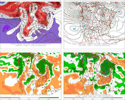
A warm and windy weekend is on tap for the area. The highest winds will likely occur over and near the mountains Saturday into Sunday. A jet stream wind speed maximum at located at about 400 millibars, or about 24,000' Mean Sea Level (see the map above) is forecast to sweep across northern New Mexico on Sunday.
Strong winds aloft are forecast to mix downward to the surface Saturday, and more so on Sunday. This along with a tightening surface pressure gradient will produce westerly winds of around 20-30 mph with higher gusts across the lower elevations, especially on Sunday.
Should this next mid-upper level trough of low pressure swing a little further to the south than is currently forecast, the SE NM would see stronger winds than is in current forecast. Our high temperatures on Saturday are forecast to be mostly in the low-mid 70's. Sunday will be a little cooler with highs in the 60's to near 70.
Next Weeks Potential Winter Storm.
Valid At 5 PM MST Tue Jan 24, 2012.
Last nights model runs have started their usual game of flip-flopping their forecast around concerning next weeks next potential Winter Storm for the area. This is to be expected given the difficult split flow pattern that has prevailed until recently this winter. A better picture of how strong and wet this next storm will be, may not occur until later this weekend, when this storm drops southward out of the Gulf of Alaska, and into the Pacific Northwest. So until then, the models may not have a good handle on this storm.
Current model forecast indicate that we may be dealing with another potentially strong Winter Storm by the middle of next week. Most of the models dig the storm southward into northern Mexico, and cut if off from the main jet stream flow to its north. How cold will the storm be, how far south will it dig, and how much moisture will it have to work with, will all be crucial as to what impacts if any this storm has on the local area.
I will keep you posted as the details emerge out of the murky waters of model forecasting.
The Truth Is Stranger Than Fiction!
My Web Page Is Best Viewed With Google Chrome.


Comments
Post a Comment
Your comments, questions, and feedback on this post/web page are welcome.