First High Wind Event Of The New Year.
Warm & Windy Today.
Guadalupe Mtn's
Valid Until 11 PM MST Tonight.
SW Winds Increasing To 40-50G70 MPH.
Lincoln & Otero Counties.
Valid Until 5 AM MST Tuesday.
West Winds Increasing To 35-45G60 MPH.
Eddy-Lea-Chaves Counties.
Valid Until 8 PM MST Tonight.
SW Winds Increasing To 25-35G50 MPH.
Strong winds aloft, a passing upper-level disturbance to our north, combined with a tightening surface pressure gradient, will generate strong gusty winds across the area today. Southwesterly winds are forecast to increase to around 25-35 mph with gusts near 50 mph across the plains by about mid-day. Stronger winds are forecast across the Guadalupe, Sacramento, and Capitan Mountains, where gusts may reach or exceed 60 mph.
Today will be unseasonably warm with afternoon high temperatures in the low-mid 70's expected across most of the local area. I few spots may climb up into the upper 70's. Patchy areas of blowing dust will be possible in the stronger gusts. This will be especially true over and near freshly plowed or exposed farmlands, fields, lots, and construction sites.
A cold front will move into the area tomorrow. This will cool our afternoon highs back down into the 60's tomorrow and Wednesday. But by Thursday we will warm back up to the low-mid 70's. Friday will likely see high temperatures in the 75-80 degree range, and Saturday most of us may reach at least the low 80's.
Does Winter Make A Comeback Next Week?
This Mornings 12Z/5 AM MST ECMWF 500 MB Forecast.
Valid At 5 AM Tue Jan 24, 2012.
This Mornings 12Z/5 AM MST ECMWF 500 MB Forecast.
Valid At 5 AM Tue Jan 24, 2012.
Valid At 5 PM MST Mon Jan 23, 2012.
Update at 1:45 PM MST Today-
This mornings 12Z run of the European model (ECMWF) develops a strong closed 500 millibar low over southeastern New Mexico by around next Tuesday, January 24th. Wow, should this forecast pan out, this would be the fourth strong Winter Storm this season to hit the local area. You can see this via the top map depicted above.
-------------------------------------------------------------
Most of the long-range models to some extent forecast a change in the mid-upper level pattern next week. It looks similar to the pattern we experienced in December into the first of this month. The European model (ECMWF) forecasts a cutoff upper-level to form over the southwestern part of the state by around next Monday, and then drops it south into northern Mexico by mid-week. This is a long ways off, and I expect to see the models offer different forecasts between now and next weekend, so we will have to take a wait and see attitude for now.
Brutal Cold Across The Yukon Territories
In Northwestern Canada.
Valid At 5 PM Tue Jan 17, 2012.
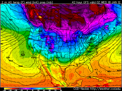
A couple of the colder temperatures that I could find across the Yukon Territories in Northwestern Canada at 6 AM MST this morning include, -54F at Mayo, -51F at Dawson, and -49F at Watson Lake. By tomorrow evening at sunset temperature departures from normal across Northwestern Canada are forecast by the GFS to be some 60-73 degrees below normal. Temperatures of -40F to -60F are forecast for this region.
The Truth Is Stranger Than Fiction!
My Web Page Is Best Viewed With Google Chrome.


Comments
Post a Comment
Your comments, questions, and feedback on this post/web page are welcome.