More Snow Headed To SE New Mexico!
Click On The Maps To Enlarge Them.
Blog updated at 3:00 PM MST Today.
Blog updated at 3:00 PM MST Today.


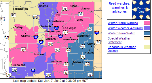
This Map Does Not Update On This Blog-
Click On The Link Below For The Latest Information.


This Map Does Not Update On This Blog-
Click On The Link Below For The Latest Information.


This Map Does Not Update On This Blog-
Click On The Link Below For The Latest Information.
Maps Are Courtesy Of The El Paso NWS Office.
Valid At 5 AM MST Mon Jan 9, 2012.

3" - 7" Snowfall Guadalupe Mtns.
3" - 6" Snowfall Lower Elevations SE NM & W TX.
Locally Heavier Totals Possible...Especially Mtn's.
Difficult To Impossible Driving Conditions.
Difficult To Impossible Driving Conditions.
N - NE Winds 10-20 mph with higher gusts.
Low Visibilities.
Sunday Evening - Monday Afternoon.
Chaves-Roosevelt-Curry-De Baca Co's.
3" - 6" Snowfall - Locally Heavier Totals Possible.
Difficult To Impossible Driving Conditions.
N - NE Winds 10-20 mph with higher gusts.
Low Visibilities.
6 AM Sunday Morning - 6 AM Monday Morning.
Lincoln-SW Chaves Co's.
6" - 9" Snowfall Above 7,500'.
Locally 12" Possible Higher Slopes.
3"- 6" Below 7,500'.
Difficult To Impossible Driving Conditions.
N - NE Winds 10-20 mph with higher gusts.
Low Visibilities.
Winter Storm Warning.
11 AM Sunday Morning - 1 PM Monday Afternoon.
Southern Sacramento Mtn's.
4" - 8" Snowfall.
Locally Heavier Totals Higher Slopes Possible.
NE Winds 10-20G35 mph.
Localized Blowing & Drifting Snow.
Winter Storm Warning.
11 AM Sunday Morning - 1 PM Monday Afternoon.
Southern Sacramento Mtn's.
4" - 8" Snowfall.
Locally Heavier Totals Higher Slopes Possible.
NE Winds 10-20G35 mph.
Localized Blowing & Drifting Snow.
Difficult To Impossible Driving Conditions.
N - NE Winds 10-20 mph with higher gusts.
Low Visibilities.
Yet Another Major Winter Storm For NM!
Update At 3:00 PM MST Today-
Current model trends indicate that yet another strong closed upper-level low will be located over southwestern New Mexico by sunset Sunday. This cold and very strong upper-level storm will then drift southeastward towards the local area Monday into Tuesday. The models may still be underestimating the strength of the storm.
Rain should break out across SE NM by around sunset Sunday, but will quickly change over to all snow. Snow will fall earlier in the day across the Sacramento and Guadalupe Mtn's. There is the real possibility that we may yet again be dealing with another Major Winter Storm across much of New Mexico, including southeastern New Mexico and nearby areas.
Much as our Christmas storm wrecked havoc with local driving conditions...this next incoming Major Winter Storm has the potential to do the same across many areas of the state, as well as the local area. Heavy snowfall is now forecast for all of our area from Sunday night into Tuesday morning.
Convective bands of snow showers (thunder snow) will also be possible...and these may produce localized very heavy snowfall totals in a few places. Road closures will be possible in many areas of New Mexico, including southeastern New Mexico, Sunday into Tuesday.
----------------------------------------------------------------------
Winter Storm #3 is getting ready to take aim on SE NM Sunday night into Tuesday. This will be Winter Storm #6 for the rest of New Mexico. After suffering through one of the most brutal summers on record, the snow and rain are very much welcome. However, once again this next Major Winter Storm is forecast to cause travel headaches across the state. For the very latest road conditions across New Mexico please visit this site. New Mexico Roads.
A strong upper-level short wave trough of low pressure is forecast to drop southward into the Four-Corners Region today. It will then settle southward into southwestern New Mexico, or southeastern Arizona tonight, and then crawl slowly eastward across southern New Mexico, or Northern Mexico Monday into Tuesday. There are still some some differences in the exact forecast track of this storm in the models, so just where the heaviest snowfall will occur, and when, is still somewhat questionable early this morning.
Southeastern New Mexico is getting ready to get hit once again with another snow storm. There is the potential for locally heavy snowfall in some areas, with the current storm total snowfall amounts in the 2" - 6" range.
A re-enforcing surge of colder air Sunday night will inject low-level upslope moisture from the east, into the upper-level storm to our west. This will set the stage for locally heavy snowfall totals across the area, especially across the mountains. Our high temps on Monday are forecast to remain in the 30's.
Yet another Winter Storm may take aim on the state by the middle to end of next week. I will post additional information on this storm later today as conditions warrant.
The Truth Is Stranger Than Fiction!


Comments
Post a Comment
Your comments, questions, and feedback on this post/web page are welcome.