Cold Front Has Arrived - Monday Continues To Look Much Colder/Wet.
Surface Map @ Noon MDT Today.
Finally our anticipated cold front has arrived...although somewhat slower than what the models had originally forecast. So this means that our high temperatures today in southeastern New Mexico and nearby areas will be a little warmer than originally forecast as well.
As of noon today the coolest reading I can find was 48ºF at the Buck Mountain Automated Weather Station (10,720') located near Sierra Blanca Peak, west of Ruidoso. A close second was the Sunspot Solar Observatory (9,255') with 49ºF. The Smokey Bear Raws in Ruidoso (7,090') was reporting a temp of 59ºF while a Personal Weather Station in Cloudcroft (8,698') was reporting 51ºF. Here at our home in Carlsbad my Davis Vantage Pro2 Home Weather Station was reporting 73ºF.
With the cold front now in West Texas and continuing to push to the south and east, and the increase in the low cloud deck, our temps will holding steady for awhile then slowly drop through the afternoon.
Northeasterly winds have gusted in the 25-40 mph range this morning along and behind the cold front.
Satellite Images Show Moisture Increasing Over The Region.
Low level upslope flow behind the cold front has commenced. Local aviation observations show that a low deck of clouds ranging from 1,900 above ground level in Hobbs, to between 3,500' and 5,500' above the ground level in the Roswell, Artesia, and Carlsbad areas continue to thicken and lower. Abundant mid and high level moisture is also streaming in from the southwest over the top of this lower cloud deck from near the Baja California Region.
As has been forecast for the past week our upper level storm continues to dig southward into Northwestern Old Mexico nearing the noon hour today. It is located south of Tucson and is forecast to become a cutoff upper level low and slowly retrograde or wobble southwestward or westward over the next day or so. The red shaded colors on the map indicate dry air at the mid levels of the atmosphere while the gray shade over West Texas and New Mexico indicates moisture. The light and darker blue blob south of Midland, Texas indicates a cluster of thunderstorms.
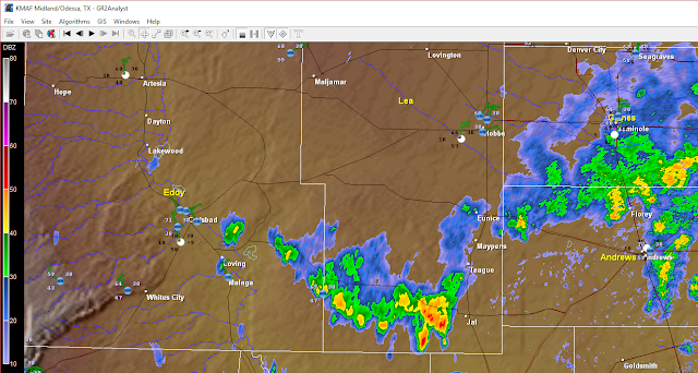
Local GR2Analyst 2.00 @ 12:50 PM MDT This Afternoon.
Radar is coming alive with echoes as the low and mid level moisture begin to interact with the upper level storm to our southwest. This trend is forecast to continue today into Monday morning.
As of 1 PM MDT this afternoon this is where the heaviest rainfall has already fallen across West Texas. Radar estimates some 3" to 6" fell roughly from the Sterling City area northeastward to the Sweetwater area over the past 24 hours.
(Valid @ 6 PM MDT Tuesday).
So with our high temperatures on Monday to be in the 50's to near 60ºF these readings will be some 20 to 30 degrees below normal for the date. Not to worry Monday will still feel very much like fall so bundle up the kiddos for school tomorrow morning.
With the cutoff low to our southwest having decided to back up, or go in reverse so to speak,(technical term is retrograde) this will lessen our chances of widespread heavy rainfall across southeastern New Mexico. Simply because its the main mechanism that is keeping the atmosphere unstable and providing the lift necessary to produce our rainfall and thunderstorms. The further away from us it is the less rain we get. Given all of this I suspect that there will be a few spots that get hammered with an inch or two of rain by Monday evening. A Flash Flood Watch remains in effect for West Texas today through Monday morning. Some locals may get another 2" to 4" of rain.
The Truth Is Stranger Than Fiction!


Comments
Post a Comment
Your comments, questions, and feedback on this post/web page are welcome.