It Rained In The Pecos Valley!
Rain In The Sacramento Mountains.
Click On The Photos To Enlarge Them.
Life giving rains return to the Sacramento Mountains this
month. Looking west towards the Dunken area.
Low clouds & fog shroud the mountain tops during an
afternoon t-storm in the Sacramento-Weed areas.
Cloudcroft's namesake.
You would think this was a fall morning shot but it wasn't. It
was taken near Sacramento, NM on the afternoon of 7-22-11.
Raindrops & puddles...A welcome site.
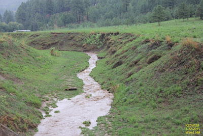
Only a trickle now...but this arroyo can become a raging torrent
during flash flood events.
Mountain runoff near Weed, NM 7-22-11.
Selected Rainfall Totals Across SE NM.
(Ending At 7 AM MDT Today).
Chaves County-
8-Mile Draw Raws .28"
7.6 NNW Roswell .20"
Roswell Climate .05"
Roswell Arpt ASOS .03"
Eddy County-
Queen Raws .77"
0.9 NE Lakewood .52"
2.0 N Downtown Carlsbad .48"
Downtown Carlsbad - OEM Bldg .45"
33.3 WSW Carlsbad - Queen .31"
2.1 NNW Downtown Carlsbad .30"
2.6 NNW Downtown Carlsbad .28"
South Artesia .21"
3.1 SSE Carlsbad .19"
4.8 SSE Artesia - Atoka .18"
Carlsbad Arpt ASOS .17"
Artesia Arpt AWOS .09"
6 SSE Artesia - Atoka/Alfaldale .06"
Otero County-
Mayhill Raws .32"
16 ESE Cloudcroft - Mayhill .30"
Carlsbad Climate .23"
Mayhill CW9878 .21"
Dark Ridge Observatory - Weed .13"
4.9 NE Cloudcroft .09"
1.8 SW Cloudcroft .08"
Pierce Canyon .08"
Dry Canyon .07"
Cloudcroft Fire Stn .06"
Cosmic Raws - Apache Summit .01"
Rainfall Data Is Courtesy Of-
Remnants Of Tropical Storm Don-
Tropical Storm Don moved inland near Baffin Bay, between Corpus Christi and Brownsville, Texas yesterday evening. Don died rapidly once inland...this was something that I didn't expect, nor did a lot of other people.
An upper level low (Tutt Low) is located over SE NM this morning, and was partly responsible for kicking off yesterday afternoon's and evening's crop of t-storm across the area. We can expect to see similar conditions again today into Sunday. Some of Don's remnant moisture (not much though) will add to the mix, and help produce widely scattered to scattered t-storms across the area.
The Truth Is Stranger Than Fiction!


Comments
Post a Comment
Your comments, questions, and feedback on this post/web page are welcome.