More Photos From The Christmas 2011 Snow Storm.

Blog updated at 8:15 PM MST Thu Dec 29, 2011.

Click On The Photos To Enlarge Them.

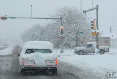
Carlsbad, New Mexico Christmas Eve.
Photo Courtesy Of Ruthie Porter.
"Desert Photos."

Carlsbad, NM Dec 24, 2011. By Brenda Wiedenmann.

Carlsbad, NM Dec 24, 2011. By David Gordon.

Queen, NM Dec 24, 2011. By Pat Wright.

Carlsbad, NM Dec 24, 2011 - C-Hill Looking Southwest.

Roswell, NM Dec 26, 2011.

Seven Rivers, NM Dec 27, 2011.

West Of Hagerman, NM Dec 27, 2011.

SECC MODIS Wed Dec 28, 2011.
Zoomed In To 1,000 Miles.

SECC MODIS Thu Dec 29, 2011.
Zoomed In To 1,000 Miles.

SECC MODIS Wed Dec 28, 2011.
Zoomed In To 250 Miles.

SECC MODIS Thu Dec 29, 2011.
Zoomed In To 250 Miles.


For Additional Photos Please Visit These Links-


The Truth Is Stranger Than Fiction!

Comments

  1. Pretty nice post. I just stumbled upon your Website and wished to say that I have really enjoyed surfing around your Website posts.Christmas Tattoos
    After all, I’ll be subscribing to your feed and I hope you write again very soon!
    Tattoos Quotes!

    ReplyDelete

Post a Comment

Your comments, questions, and feedback on this post/web page are welcome.

NWS Midland Radar

Cannon AFB Radar

NWS Albuquerque Radar

NWS Lubbock Radar

Holloman AFB Radar

NWS El Paso Radar

South Plains Radar

Southern Rockies Radar

Regional Radar

Current Watches In Effect

SPC Mesoscale Discussions

Storm Prediction Center (SPC) Day 1 Severe Weather Outlook

Current NWS National Watches/Warnings In Effect

Current NWS National Watches/Warnings In Effect
Click On The Map For The Latest Updates

New Mexico

Eddy County Plains & Guadalupe Mtn's

Guadalupe Mtn's In Culberson County

Chaves County Plains & Mtn's

Lea County

Lincoln County

Otero County

Current US Temps

Current US Wind Chill/Heat Index Temperatures

NWS Forecast High Temps Today

NWS Forecast Low Temps Tonight

NWS Albuquerque Storm Total Rainfall Forecast

NWS Midland Storm Total Rainfall Forecast

NWS El Paso Storm Total Rainfall Forecast

Average Daily High/Low Temperatures

Average Daily High/Low Temperatures