

Winter-Like Temps This Morning.
Click On The Maps To Enlarge Them.
Blog Updated @ 8:30 AM MDT.


Visible Satellite Image @ 7:30 AM MDT This Morning.
 Map Is Courtesy Of The Midland NWS Office.
 Map Is Courtesy Of The Lubbock NWS Office.
 Record Low-Max Temps In Danger Of Being Broken Today In NM.
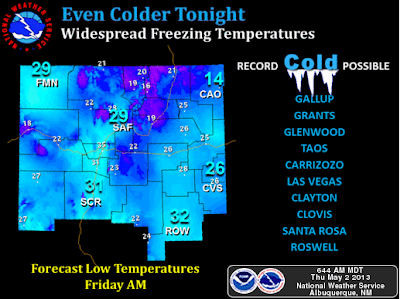 Record Low Temps Possible Tonight Across New Mexico.
A Freeze Watch remains in effect for southeastern New Mexico into tomorrow morning. Record low temperatures below freezing are forecast tonight. In fact some locations will be in danger of breaking their all-time low temperatures recorded for the month of May. Unbelievable.


A Freeze Watch remains in effect for southeastern New Mexico into tomorrow morning. Record low temperatures below freezing are forecast tonight. In fact some locations will be in danger of breaking their all-time low temperatures recorded for the month of May. Unbelievable.
The Truth Is Stranger Than Fiction!
My Web Page Is Best Viewed With Google Chrome.


Comments
Post a Comment
Your comments, questions, and feedback on this post/web page are welcome.