

Major Winter Storm Impacts NM Today Into Tuesday.

Valid @ 7:45 AM MST This Morning.
Major Winter Storm To Impact Much Of New Mexico.


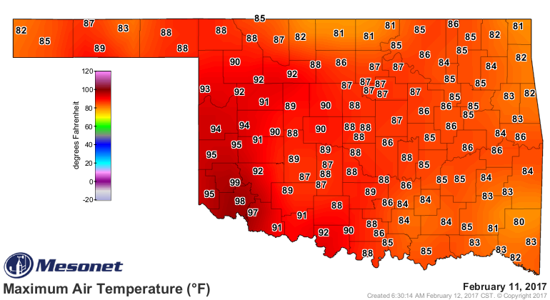
High temperatures Saturday afternoon once again soared up into the 90's from Southeastern New Mexico and parts of West Texas to Southwestern Oklahoma. My high temp here at our home in Carlsbad reached 90ºF. The nations high was recorded at Rio Grande Village, Texas with 100ºF. A high temp of 99ºF was also noted in far Southwestern Oklahoma.
Cutoff Upper Level Low Has Settled In South Of San Diego.

Valid @ 5 AM MST This Sunday Morning.
GFS 500 MB (18,000' MSL) Forecast.

Valid @ 5 AM MST Tuesday Morning.
Looking at the water vapor satellite image above you can clearly see where the 500 millibar cutoff upper level low was located at 7:45 AM MST this morning. The storm had dropped south of San Diego just west of the Baja Peninsula out over the Pacific Ocean. All of the models slide this low slowly eastward across Northern Mexico and into or near Southeastern New Mexico by Tuesday. There are some differences in the track and speed concerning this but overall the general theme remains the same.
This storm has dropped off of the upper air grid so I'm not convinced that this morning's model runs have a good handle on it. In other words it appears that there isn't sufficient enough data in this morning's upper air data to correctly depict the strength of the storm thus the models in my opinion seem to be underestimating the storm. This could have huge impacts upon our local forecasts. If this is correct then I think we will end up with more snow in Southeastern New Mexico than is currently being forecast. But if in fact the models are correct we also could end up with less.
This storm has dropped off of the upper air grid so I'm not convinced that this morning's model runs have a good handle on it. In other words it appears that there isn't sufficient enough data in this morning's upper air data to correctly depict the strength of the storm thus the models in my opinion seem to be underestimating the storm. This could have huge impacts upon our local forecasts. If this is correct then I think we will end up with more snow in Southeastern New Mexico than is currently being forecast. But if in fact the models are correct we also could end up with less.

Valid @ 5 AM MST This Sunday Morning.

Valid @ 5 AM MST Monday.
Surface Map Forecast.

Valid @ 5 PM MST Monday.
Much colder air is overspreading the area behind the surface cold front that rushed through the state overnight. Northeast to easterly winds are gusting in the 35 to 55 mph range this morning across the Eastern and Southeastern Plains, as well as across the Rio Grande Valley and in the Capitan and Carrizozo areas. Today's high temperatures on average across New Mexico will be some 30-degrees colder than Saturday's readings. Most communities in the state more than likely will have already reached their daily high temp by noontime with steadily falling temps throughout the day. Monday's highs will be even colder with another 10 to 20-degree drop in temps compared to today's readings.
Temps Drop 30-Degrees Today Verses Saturday.
Today.


Monday.


Experimental NWS Storm Total Snowfall/Ice Forecasts.
(As Of 10 AM MST This Sunday Morning).


(As Of 10 AM MST This Sunday Morning).


Major Winter Storm To Impact Much Of NM Today Into Tuesday.
Winter Storm Warnings are now in effect for much of the northern two thirds of New Mexico through Tuesday including Chaves, Lincoln, and Otero Counties. The Roswell area could receive 3" to 7" of snow from this storm. Winter Storm Warnings are also in effect for the Sacramento Mountains through Tuesday. Local web cams show snow already falling over the Sacramento Mountains as of 10 AM MST this Sunday morning.
Heavy to very heavy snow is forecast for the mountains of the state including the Sacramento's where 10" to 20" storm total accumulations will be possible by Tuesday above roughly about 7,000'. This includes the Interstate I-40 corridor from Tijeras east to Clines Corners. Below that storm total accumulations are forecast to be in the 4" to 9" range. Snowfall accumulations across the Northeastern and Eastern Plains will range from 5" to 10".
Freezing rain and sleet is also forecast for the Eastern and Southeastern Plains off and on at times tonight into Monday night. By Tuesday the precipitation should have changed over to all snow. Accumulating ice is possible from Roswell northeast to the Portales and Clovis areas.
Currently (As of 10:30 AM MST Sunday) there are no Winter Watches or Warnings in effect for Eddy, Lea, or Culberson Counties. I suspect that this could change later today. Current NWS forecasts for Eddy and Lea Counties calls for a mix of rain, freezing rain, sleet, and snow tonight through Tuesday with some light accumulations of ice and snow possible, mainly Monday night into Tuesday. However please check our local forecasts frequently especially if you have travel plans since this forecast may change with a trend towards worsening conditions across Eddy and Lea Counties..
Difficult and dangerous driving conditions (or NM Roads) will occur over a large part of New Mexico tonight into Tuesday. This will be especially true in and near the mountains, and over the Northeastern, Eastern, and Southeastern Plains. A combination of snow which will be heavy at times, blowing and drifting snow, freezing rain and sleet will cause numerous problems on many of the state's highways in the warned areas. Travel in some locals may become impossible along with road closures. White out conditions will be possible in some of these areas dropping the visibility down to near zero at times. For the latest road conditions across the area please visit this link:
Computer Model Snowfall/Rainfall Forecasts.
(Worst Case Scenario).

Valid @ 5 AM MST Wednesday Morning.
NWS NDFD Ice Accumulation Forecast.

Valid @ 5 PM MST Tuesday.
NWS NDFD Storm Total Rainfall Forecasts.

Valid @ 5 PM MST Tuesday.
As I mentioned above the models in my opinion seem to be struggling with their snowfall forecasts concerning this storm now. So I've opted to not include them so as to not add confusion to ongoing forecasts. Where the temperature remains warm enough to prevent snowfall rain is forecast to fall, some of which may be moderate to heavy. Overall this should be a wet storm.
The Truth Is Stranger Than Fiction!


Comments
Post a Comment
Your comments, questions, and feedback on this post/web page are welcome.