Increasing Chance For T-Storms Late Tonight Into Sunday Morning.
Heavy rains have fallen the past several days across the Desert Southwest. Its pretty unusual to see this much rainfall in these areas in March. Which is pretty much our driest month of the year for many of us. And more to come tonight into mid-week. Image how beautiful the desert will be soon!
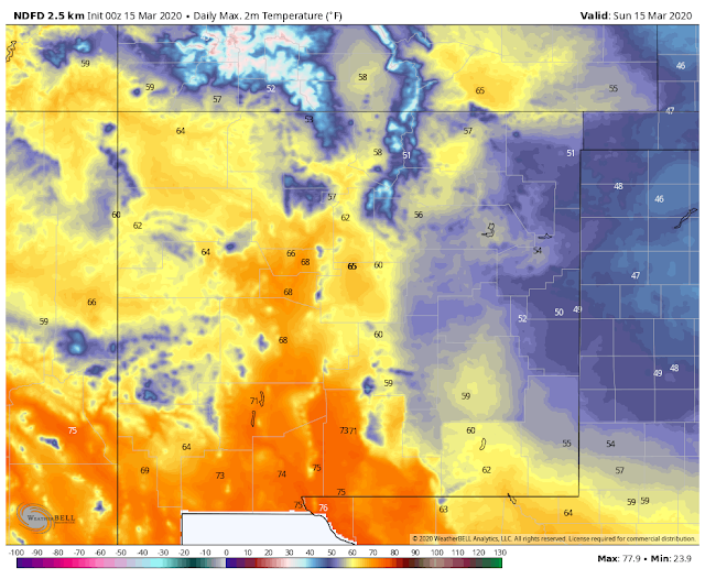
Valid At 6 PM MDT Sunday Afternoon.
Temperatures at 6:30 PM MDT ranger from the 70's across parts of SE NM & W TX to the 30's in the Oklahoma Panhandle behind the cold front.
(Overnight Into Early Sunday Morning).
Valid Late Tonight Into Sunday Afternoon.
Stormy Late Tonight Into Early Sunday Morning.
A stalled cold front to our northeast will backdoor to the south and southwest overnight tonight reaching the Southeastern Plains early Sunday morning. This slow-moving cold front combined with a couple of disturbances being ejected northeastward over the area will aide in destabilizing the atmosphere overnight.
Scattered thunderstorms are forecast to form late tonight into Sunday morning. A few of these may become Marginally Severe and produce large hail. These will be elevated supercell type thunderstorms.
Low clouds and fog are forecast to develop behind the cold front as it slips into the local area early Sunday morning. Our chances for thunderstorms will increase later tonight into Sunday morning and generally will be in the 40% to 70% range.
Locally heavy rain will be possible especially across southern Lea County into West Texas and across parts of southern Eddy County. This could possibly lead to localized flash flooding especially since some of these locals have received heavy rain the past couple of days.
Sunday will much colder with highs ranging from the 40's in the Clovis and Portales areas and the mountains, to the mid 50's to the low 60's across Chaves, Lea, and Eddy Counties.
The Truth Is Stranger Than Fiction - And Sometimes It Hurts!


Comments
Post a Comment
Your comments, questions, and feedback on this post/web page are welcome.