

First Look At Next Weeks Cold & Winter Storm.
Valid Next Wednesday.

Canadian Model (GEM).

U.S. Model (GFS).

European Model (ECMWF).

German Model (ICON).

National Blend Of Models (NBM).

(At 5 AM MST Saturday, February 5, 2022).


Albuquerque.

Santa Fe.

Clovis.


Coldest/Strongest Winter Storm This Season Next Week?
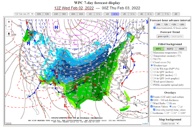
Computer forecast models this morning were relatively close to one another considering their forecasts for a winter storm to impact the state and region next week. As always the models have their differences in the strength, timing, and track of the storm but all agree that winter rules next our weather next week. We are still 5 days away from the beginning of the storm's impacts locally but it's time to start talking about its potential impacts...which could be significant. I chose the Canadian (GEM) model for today's blog. It is pretty close to the European (ECMWF) and the U.S. (GFS) model forecasts...but the coldest of the three.
Points To Consider For Next Weeks Potential Winter Weather.
1. The long-wave trough of low pressure may or may not crave out a closed low over the Four Corners area towards the middle to end of next week. This could prolong and increase the precipitation (snow) areawide if it does. It would also mean more of a widespread and heavier snow event. If the storm sweeps across the area as a trough of low pressure...this would mean less snow ending sooner and not as widespread.
2. An Arctic airmass associated with the storm could bring the coldest temperatures of the winter for much of the region. With the potential for a multiday subfreezing temperature event to develop Wednesday into Saturday (depending upon where you live) if the Canadian model forecasts are correct. The Canadian model hints at single-digit lows across much of New Mexico's lower elevations late next week. With below zero readings across most mountainous areas. This remains subject to change and is not written in stone at this time.
3. Very cold temperatures along with dangerous wind chill temperatures look fairly certain early on (Thursday morning into the day). There is a chance that the cold (especially if it is several days in occurrence) may have a bigger weather story with a more significant impact upon the region than the snow. Either way, our regional weather will change significantly next week towards much colder and stormier.
4. The U.S. GFS model forecasts brutal wind chill temperatures Thursday morning for all of the region. Ranging from near zero in the Southeastern Plains of New Mexico to -10ºF to -20ºF over the Northeastern and Eastern Plains, and parts of the Central mountain chain. As well as over the Texas Panhandle and South Plains.
5. At this early stage all four of the long-range forecast models (GFS, ECMWF, GEM, ICON) forecast a widespread snow event for the Four Corners area into Texas Wednesday into Friday. Some areas could see heavy snow, especially in the mountains. Heavy snow is not out of the question, especially for the state's mountains. But pinpointing how much and where now is not possible now.
6. Much will change in the model forecasts as we head into next week. There remains a great deal of uncertainty concerning the details of next week's cold weather and the potential for a winter storm. The forecast models are a guide we use to forecast these events. This is the first look. Just know that for now there is a reasonable chance of our weather turning much colder, with the chance for some snow over most of the area from Wednesday into perhaps Friday. Keep abreast of all of your local forecasts concerning next week's potential storm. Our local National Weather Service forecasts, watches, warnings, current conditions, radar, satellite and much more are available on my main weather web page...Welcome To Southeast New Mexico Weather.
6. Much will change in the model forecasts as we head into next week. There remains a great deal of uncertainty concerning the details of next week's cold weather and the potential for a winter storm. The forecast models are a guide we use to forecast these events. This is the first look. Just know that for now there is a reasonable chance of our weather turning much colder, with the chance for some snow over most of the area from Wednesday into perhaps Friday. Keep abreast of all of your local forecasts concerning next week's potential storm. Our local National Weather Service forecasts, watches, warnings, current conditions, radar, satellite and much more are available on my main weather web page...Welcome To Southeast New Mexico Weather.
7. At this early stage the model forecasts have some semblance in their forecasts to the bitterly cold arctic outbreak that hammered the region last February. I'm not saying at this time that this storm will be as bad or as cold as last year's. But there are some similarities in the model forecasts that bear watching to see how this one pans out. See my blog posts from last year about this event.
FEBRUARY 12-19, 2021 HISTORIC WINTER STORM SUMMARY #1.
FEBRUARY 12-19, 2021 HISTORIC WINTER STORM SUMMARY #1.
The Truth Is Stranger Than Fiction!


Let’s hope so! We really need the moisture.
ReplyDelete