


Worst Of The Storm Today Into Tonight - Frigid Sunday Morning!
(At 8:06 AM MST).
(At 9:00) AM MST).
Worst Of The Storm Today Into Tonight - Frigid Sunday Morning!
A quick update at 9:30 AM MST New Year's Day.
Don't let your guard down folks...especially those of you who live in western, northwestern, northern, northeastern, and parts of central New Mexico.
Round 1 (yesterday into last night) has ended. Now round 2 is underway across the state. The worst is yet to come!
The cold and strong long-wave trough of low pressure is digging south from the Great Basin into central Arizona as of this writing.
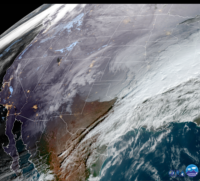
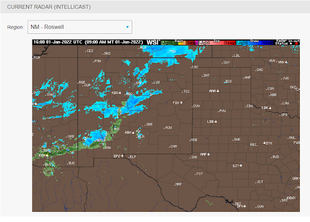
Take a look at the Geo Color satellite snapshot and regional radar at 9:00 AM this morning. Low clouds can be seen along, and north of the brutally cold arctic cold front over the Texas panhandle and Eastern New Mexico. Low and mid-level clouds stretch in a band from southern Arizona into northern New Mexico. This is storm #2 moving into New Mexico.
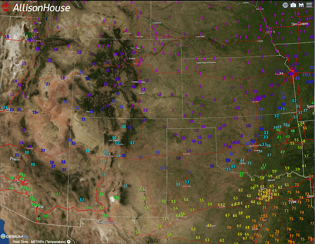
The arctic cold front is now south of Clovis and north of Roswell. At 9 AM the temp in Clovis was 20ºF, with northeast winds at 22 mph producing a wind chill of 4ºF. Temperatures are in the teens in northeastern New Mexico and the northern Texas Panhandle. They are in the single digits in southeastern Colorado and western Kansas with wind chills down to -10ºF to -20ºF.
Meanwhile here in Carlsbad, south of the arctic cold front, it's 54ºF with a west-southwest wind gusting to 44 mph. A gust to 73 mph was recorded at the Bat Draw Raws at the Carlsbad Caverns National Park at 4:52 AM MST. The Pinery Raws (Remote Automated Weather Station) located in Pine Springs in the Guadalupe Mountains National Park southwest of Carlsbad clocked a gust of 74 mph at 1:52 AM MST, as did the Bowl Raws at 2:38 AM MST.
For those of you who have been missing winter...trust me, it's coming your way fast.
Numerous Winter Storm Warnings and Winter Weather Advisories continue in effect across the state. These remain in effect through tonight.
Moderate to heavy snow is falling in Ruidoso with west-southwest winds gusting to 48 mph. At least 6" has been reported at Ski Apache this morning. Roads are slick and icy.
Heavy snow fell in the Cloudcroft area yesterday. A CoCoRaHS Observer located 1.8 miles southwest of Cloudcroft reports 12.5" of new snowfall this morning. With a total of 13.1" the past two days.
Snow heavy at times today into tonight along with blowing snow, drifting snow will cause travel disruptions across many areas of the state under Warnings and Advisories.
Whiteout conditions and blizzard conditions will be possible with the 50-65 mph wind gusts over the Sacramento and Capitan mountains. And across parts of northern and western New Mexico at the higher elevations with the strongest gusts. Sudden drops in the visibility down to near zero may occur with little to no advance warning.
Life-threatening weather conditions will impact these areas today into Sunday morning. Dangerous wind chill values of 0ºF to -20ºF will occur in parts of these areas including the Sacramento and Capitan mountains. If you do not have to travel then consider staying at home if you are able.
Across the Southeastern Plains yet another high wind/blowing dust event is possible today ahead of the southward moving arctic cold front. Southwest to west winds are forecast to gust up to around 50-60 mph, locally higher. Across the Guadalupe mountains, these winds are forecast to gust up to 85 mph.
Local travel issues may become a problem during the strongest wind gusts and associated localized blowing dust. Sudden drops in the visibility down to near zero may occur with little to no advance warning. Some localized damages may occur should the gusts exceed 65 mph.
Sunday morning will see the coldest air of the season envelope the local area and state. Locally we will see our low temps drop down into the single digits and teens across the Southeastern Plains. Wind chill values will drop down into the single digits to subzero readings tonight.
Singel digit low temperatures are expected in the Sacramento and Capitan mountains with wind chills this afternoon into tonight in the 0ºF to -15ºF range.
The Truth Is Stranger Than Fiction!


Comments
Post a Comment
Your comments, questions, and feedback on this post/web page are welcome.