

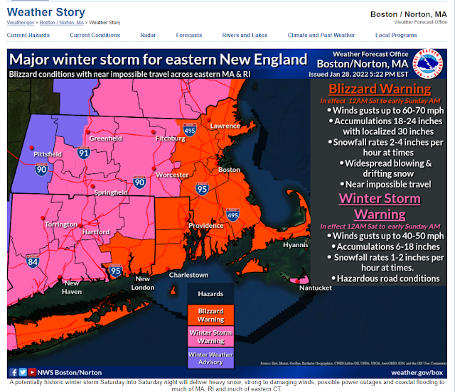
Historic Major Winter Storm For Southern New England Tonight Into Saturday!
A fascinating Area Forecast Discussion (AFD) from the Norton/Boston, MA National Weather Service Forecast Office this afternoon. You just don't see this very often. I want so bad to be there.
Blizzard Warnings!
Quote-
"FXUS61 KBOX 282125
AFDBOX
.SYNOPSIS...
A cold front moves through the region this afternoon, possibly
accompanied by a few snow showers or flurries. A historic major
winter storm will impact much of southern New England Saturday
into Saturday evening, bringing heavy snow, blizzard conditions
to the much of southeastern New England, and possibly damaging
winds and coastal flooding. Drier weather returns with below
normal temperatures Sunday before a warm up next week.
&&
.NEAR TERM /UNTIL MIDNIGHT TONIGHT/...
Quiet before the storm through this evening. So be sure to take
advantage to make any pre-storm preparation. There are some flurries or scattered light snow showers associated with a weak disturbance.
A cold front moves across southern New England this evening with
temperatures slowly falling into the mid 20s to low 30s.
&&
.SHORT TERM /MIDNIGHT TONIGHT THROUGH SATURDAY NIGHT/...
Highlights...
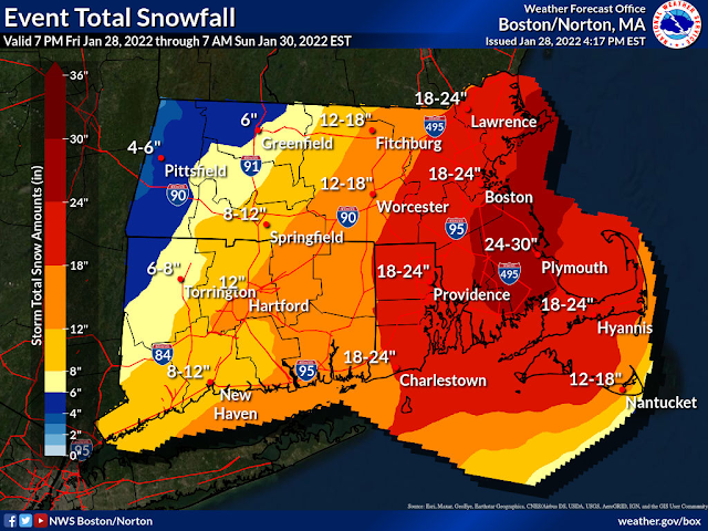
* We now have high confidence in a historic major winter storm for
eastern New England. Widespread 1 to 2 ft snowfall with localized
3 ft is likely for eastern MA and RI along with blizzard
conditions.
* Snowfall rates could reach 2 to 4 inches per hour at times during
the day on Saturday with possibility of thundersnow across eastern MA and RI.
* In addition to potential historical snowfall, strong winds up to
hurricane force especially along the coast will lead to bitterly
cold wind chills on Saturday along with minor to moderate coastal
flooding.
Details...
Heavy snowfall/Extreme snowfall rates...
Models have now come into consensus for a historical blizzard to
impact eastern southern New England. Explosive cyclogenesis will
occur off the Mid Atlantic coast tonight, with an impressive 40 mb
pressure drop in 24 hours as a surface low tracks from east of the
Carolinas to the 70W/40N benchmark. For reference, a bomb cyclone`s criteria is a drop of 24 mb in 24 hours. At this point within 24 hours of the storm, we are now in the time frame where the NAM generally performs well during an East Coast cyclogenesis event.
We now have high confidence in exceptional to extreme snowfall rates with the possibility for thundersnow across eastern MA and RI.
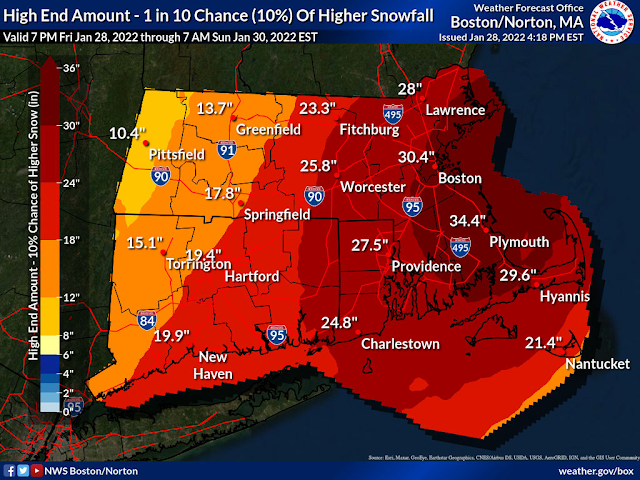
Somewhat lower confidence in the exact placement of the heaviest
band, however. Both NAM and GFS Bufkit soundings show over 50 units of omega coinciding with the favorable snow growth region. Given that a double-barrel low could develop with the potential for an eye-like feature at some point, wherever the mesoscale snow band sets up could see 2 to 4 inches per hour snowfall rates with an outside chance for 5 inches per hour especially when on the backside of the system. If a deformation band can persist when the arctic air arrives later in the day, snow to liquid ratios (SLRs) could be as high as 20-25 to 1. Therefore, we felt confident enough in this
forecast package to introduce an area of 24 to 30 inches storm total snowfall. It is possible that this band could set up further west,
or there may be two bands of heavy snow with lesser amounts in
between. Either way, we are confident enough to go with a Blizzard
Warning for the potential of blowing and drifting snow with near
zero visibility at times across much of eastern MA and RI.
Strong winds/Blowing snow...
With 925mb winds at 65-70 kts or 4 to 5 standard deviations above
normal according to GEFS and NAEFS situational awareness table and combined with excellent mixing, there will be hurricane-force wind gusts at times along the immediate coast and 50-60 mph gusts further inland. This will translate to widespread drifting and blowing of snow with localized snow drifts of up to 4 ft or higher. With temperatures in the teens to low 20s, we have high confidence in rather widespread blizzard conditions across eastern MA and RI, including the Providence to Boston corridor. Based on the latest guidance trends, it is possible that the I-95 or even the I-495 corridor ends up with a secondary local snowfall maxima. The silver lining is that because we are dealing with dry powdery fluff, there is less of a concern for snow loading issues except for parts of the Outer Cape and Nantucket due to the coastal front.
Power outage potential looks to be highest across Cape/Islands,
where the warmer temps would lead to heavier and wetter snow and consequently higher snow loading. With 70 mph winds, power outages will be likely.
There is somewhat lower confidence how far west the heavy snow
overspreads and this is something that we cannot be entirely sure
until the mesoscale band sets up as the storm gets going tomorrow
morning. While we do think that Plymouth county is still going to
end up with one of the highest totals for this storm, however, the
SLRs may be affected by the Dendritic Growth Zone`s less than ideal coincidence with the best omega resulting in riming and the fact that the hurricane-force gusts could break up dendrites.
Temperatures...
We will start the day off in the teens across north and west of the
I-95 corridor with some uncertainty how far inland the coastal front
makes. Temp will be right around or just above freezing along and
east of the coastal front. But this coastal front will collapse
eastward through late morning into the afternoon. In other words,
the biggest risk for heavy, wet snow will be across Cape Cod and the Islands prior to the collapse of the coastal front. Taking into
account the strong winds, wind chill values will be between +5 to -
10F across the interior and 0 to +10F closer to the coast. So not
quite Wind Chill Advisory criteria, but given the potential for near
white-out conditions at times, again, don`t venture out if at all
possible because it could become a life-threatening situation.
Coastal flooding...
See coastal flooding section for discussion.
&&
.LONG TERM /SUNDAY THROUGH FRIDAY/...
Highlights...
* Relatively quiet with increasingly mild weather to follow through
most of next week.
Low pressure moves off into the Maritimes Sunday, leaving southern New England in a diminishing westerly flow. Mostly sunny skies will allow temperatures to recover some, but with fresh snow cover across most of our region, expecting it will be a struggle just to reach the 20s. High pressure should pass us by Tuesday, leading to a warming trend from mid-week into next Friday.
Next chance for some wet weather comes around Wednesday with an approaching front. This front likely stalls to our west, potentially
providing a path for a low pressure to travel to our west late next
week. Looking more like rain at this time, but did not pay too much
attention to the details of a Day 6-7 forecast with the impending
storm.
&&"
The Truth Is Stranger Than Fiction!


Comments
Post a Comment
Your comments, questions, and feedback on this post/web page are welcome.