

New Year's 2022 Winter Storm Summary.
(January 2, 2022).
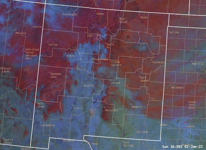
Not a cloud in the sky this morning, which makes for great viewing of the snow cover! In this image, red is snow, while aqua colors are bare ground. #nmwx
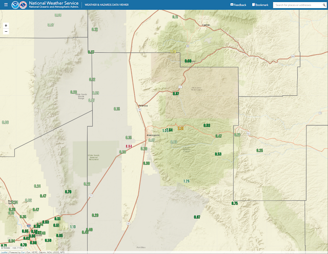
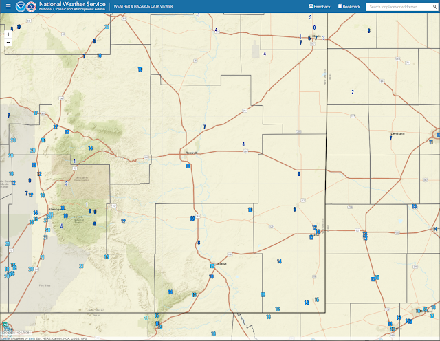
NM Storm Total Reported Snowfall Amounts.


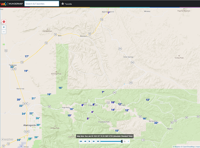
I'm not sure why the southern Sacramento mountain snowfall reports are not showing up on this map.

The 17.4" of snowfall recorded at the CoCoRaHS station located 1.8 miles southwest of Cloudcroft was the highest total in the Sac's that I could find. Their 4-day precipitation total was 3.00" and was also the highest reported in New Mexico. This was the greatest CoCoRaHS total reported in New Mexico from this storm.
The Sunspot CoCoRaHS station located 0.2 SSW was also one of the big winners as far as snowfall totals from the New Year's Storm go. That station reported a 4-day storm total of 16.1".
12.7" was measured 0.4 miles east-southeast of Cloudcroft, and 11.5" 2.3 miles south of Cloudcroft. I expected to see more in the Mayhill area but that didn't happen. A CoCoRaHS station located 2.8 miles west-northwest reported 1.2" of snowfall and a storm total of 1.03" of precipitation.
Power outages occurred in the Cloudcroft area due to the heavy wet snow breaking tree limbs that fell onto power lines along with the high wind gusts.

NM Storm Total Reported Precipitation Totals.
NM 48-CoCoRaHS 48-Hour Reported Rainfall Totals.


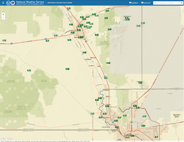
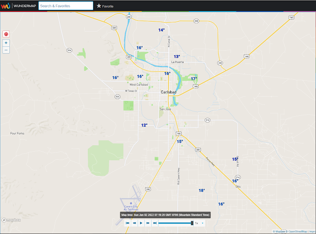
Moderate to heavy rain fell over the Sacramento and Capitan mountains as well as southern across New Mexico. As was expected the Southeastern Plains was pretty much left out precipitation-wise. I managed a storm total of 0.08" here at our home in Carlsbad. I saw a few snow flurries falling last night at 9 pm. Roswell, Artesia, and Hobbs also reported light snowfall with some ground cover noted in Lovington.
(Sunday, January 2, 2022).


(Sunday, January 2, 2022).


Single-digit overnight low temperatures were common locally over the Southeastern Plains and the Sacramento and Capitan mountains this Sunday morning. Several locations got down close to 0ºF. Locally this generally is the coldest morning of the season so far.
(New Years Day, 2022).


000
NOUS44 KEPZ 021432
PNSEPZ
NMZ401>417-TXZ418>424-030232-

Public Information Statement
Spotter Reports
National Weather Service El Paso TX
732 AM MST Sun Jan 02 2022

The following are unofficial observations taken during the storm that
has been affecting our region. Appreciation is extended to Skywarn
spotters, news media, and mesonet operators including West Texas
Mesonet and the Dona Ana County Flood Commission. This summary also
is available on our home page at weather.gov/ElPaso.

***********************PEAK WIND GUST***********************

LOCATION             MAX WIND     TIME/DATE   COMMENTS
                        GUST            OF
                         MPH    MEASUREMENT

NEW MEXICO

...Dona Ana County...
   6 ESE WSMR Main Post    57  1025 AM  1/01  ELEV 4006 FT WSMR
   KLRU                    55   235 PM  1/01  ELEV 4455 FT AWOS
   5 WNW Santa Teresa      54  1132 AM  1/01  ELEV 4115 FT RSOIS
   Dripping Springs        54   326 PM  1/01  ELEV 5885 FT RAWS
   18 NE WSMR Main Post    53  1050 AM  1/01  ELEV 3951 FT WSMR
   10 ENE Akela            51   244 PM  1/01  ELEV 4328 FT DACFC
   11 NE Organ             51   201 PM  1/01  ELEV 6138 FT RAWS
   4 NE Las Cruces         47  1100 AM  1/01  ELEV 4325 FT DACFC
   5 NE Las Cruces         43   343 PM  1/01  ELEV 4406 FT DACFC
   9 NE Las Cruces         43   300 PM  1/01  ELEV 4551 FT DACFC
   Organ                   43   943 AM  1/01  ELEV 5174 FT DACFC
   12 WSW Las Cruces       41   252 PM  1/01  ELEV 4432 FT DACFC
   2 E Chaparral           39  1143 AM  1/01  ELEV 4079 FT DACFC
   4 ENE Las Cruces        39  1100 AM  1/01  ELEV 4265 FT DACFC
   1 NE La Union           38  1131 AM  1/01  ELEV 3787 FT CWOP
   6 NE Afton              38   333 PM  1/01  ELEV 4239 FT DACFC
   2 NNE Radium Springs    37   301 PM  1/01  ELEV 4295 FT DACFC
   2 WSW Las Cruces        37   456 PM  1/01  ELEV 3902 FT DACFC
   5 NNE Las Cruces        37  1057 AM  1/01  ELEV 4327 FT DACFC
   5 NE Las Cruces         36  1027 AM  1/01  ELEV 4321 FT CWOP
   5 NNE Las Cruces        36   301 PM  1/01  ELEV 4324 FT DACFC
   2 SE Las Cruces         35  1100 AM  1/01  ELEV 3891 FT NMCC
   High Valley             35   317 PM  1/01  ELEV 4211 FT DACFC

...Grant County...
   KSVC                    45   235 PM  1/01  ELEV 5443 FT AWOS
   1 SSW Pinos Altos       38   301 PM  1/01  ELEV 6835 FT CWOP
   Lake Roberts            37   110 PM  1/01  ELEV 6031 FT EPZWXN

...Hidalgo County...
   15 SSW Hachita          59   740 AM  1/01  ELEV 4291 FT RAWS
   6 WSW Lordsburg         54   120 PM  1/01  ELEV 4265 FT NMDOT
   6 NE Road Forks         53   125 PM  1/01  ELEV 4148 FT NMDOT
   5 NE Road Forks         52   135 PM  1/01  ELEV 4149 FT NMDOT
   4 NE Road Forks         51   125 PM  1/01  ELEV 4153 FT NMDOT
   2 NE Road Forks         51   155 PM  1/01  ELEV 4158 FT NMDOT
   2 N Rodeo               49   150 PM  1/01  ELEV 4104 FT DRI

...Otero County...
   3 NE White Sands NM     51   200 PM  1/01  ELEV 4063 FT WSMR
   9 W Tularosa            51   200 PM  1/01  ELEV 4050 FT WSMR
   KALM                    51   215 PM  1/01  ELEV 4196 FT AWOS
   28 ENE Orogrande        51  1237 PM  1/01  ELEV 4886 FT RAWS
   Mescalero               51   241 PM  1/01  ELEV 6227 FT RAWS
   9 NE WSMR Main Post     51   500 PM  1/01  ELEV 3999 FT WSMR
   8 W Tularosa            50   205 PM  1/01  ELEV 4152 FT WSMR
   4 NW Orogrande          49   435 PM  1/01  ELEV 4183 FT WSMR
   Holloman AFB            48  1113 AM  1/01  ELEV 4094 FT AWOS
   14 WNW Orogrande        48   230 PM  1/01  ELEV 4040 FT WSMR
   Sunspot                 47   400 PM  1/01  ELEV 9255 FT WSMR
   15 W Orogrande          45   315 PM  1/01  ELEV 4029 FT WSMR
   19 WNW Tularosa         44  1030 AM  1/01  ELEV 4025 FT WSMR
   3 NW Mayhill            43  1000 AM  1/01  ELEV 7187 FT CWOP
   10 NW Tularosa          36   230 PM  1/01  ELEV 4237 FT WSMR
   Bell Canyon             35   141 PM  1/01  ELEV 7525 FT CWOP

...Sierra County...
   20 WNW Tularosa         46  1010 AM  1/01  ELEV 4055 FT WSMR
   Spaceport America       45   845 AM  1/01  ELEV 4597 FT AWOS
   Winston                 42  1130 AM  1/01  ELEV 6192 FT EPZWXN
   2 N Arrey               37   215 PM  1/01  ELEV 4197 FT CWOP

TEXAS

...El Paso County...
   South Franklin Peak     70   759 AM  1/01  ELEV 6614 FT CWOP
   10 NNE El Paso          55  1000 AM  1/01  ELEV 3958 FT TCEQ
   11 NE El Paso           54  1130 AM  1/01  ELEV 4007 FT CWOP
   2 WNW El Paso           53  1100 AM  1/01  ELEV 3799 FT TCEQ
   1 N Socorro             52  1100 AM  1/01  ELEV 3639 FT TCEQ
   5 ESE El Paso           49   700 PM  1/01  ELEV 3681 FT TCEQ
   5 ENE El Paso           48  1100 AM  1/01  ELEV 3740 FT TCEQ
   9 SW El Paso            43   100 PM  1/01  ELEV 3661 FT TCEQ
   12 E El Paso            38   101 PM  1/01  ELEV 3999 FT CWOP

...Hudspeth County...
   15 ENE Dell City        43   153 PM  1/01  ELEV 3873 FT RAWS

$$

BIRD
000
NOUS45 KABQ 021647
PNSABQ
NMZ201>241-030447-

Public Information Statement
National Weather Service Albuquerque NM
947 AM MST Sun Jan 2 2022

...SNOWFALL REPORTS...

Location                     Amount    Time/Date

...New Mexico...

...Bernalillo County...
4 NW Sandia Park             11.0 in   0754 AM 01/02
Edgewood 9.9 SSW             5.5 in    0800 AM 01/01
Tijeras 10.1 SSE             5.4 in    0700 AM 01/02
Tijeras 9.1 SE               5.4 in    0700 AM 01/02
Tijeras 7.2 SSE              5.0 in    0700 AM 01/02
Tijeras 5.1 E                4.8 in    0700 AM 01/02
Sedillo                      4.0 in    0829 AM 01/01
Tijeras 8.2 SSE              4.0 in    0700 AM 01/02
Tijeras 3.5 E                3.8 in    0800 AM 01/01
Tijeras 7.8 SSE              3.3 in    0700 AM 01/01
Edgewood 11.4 SSW            3.0 in    0700 AM 01/02
Sandia Park 3.7 ESE          2.5 in    0700 AM 01/02
Sandia Park 0.5 S            2.3 in    0900 AM 01/02
Sandia Park 4.9 ESE          2.1 in    0700 AM 01/01
Sandia Park 3.7 ESE          2.0 in    0700 AM 01/01
Cedar Crest 3.0 NNE          2.0 in    0700 AM 01/02
Edgewood 4.4 W               1.7 in    0800 AM 01/01
Tijeras 4.8 E                1.0 in    0700 AM 01/02
Albuquerque 9.5 ENE           T in     0600 AM 01/01
Albuquerque 8.0 ESE           T in     0700 AM 01/01
3 ESE North Valley            T in     0700 AM 01/02
Albuquerque 7.8 ESE           T in     0700 AM 01/02
Albuquerque 5.3 S             T in     0700 AM 01/02
Albuquerque 5.0 ESE           T in     0700 AM 01/02
Albuquerque 8.0 ESE           T in     0720 AM 01/02
Albuquerque 5.0 NE            T in     0800 AM 01/02
Albuquerque 2.1 S             T in     0830 AM 01/02
Albuquerque 6.6 E             T in     0830 AM 01/02

...Catron County...
Pie Town 0.1 WNW             12.0 in   0700 AM 01/02
6 WNW Pietown                10.0 in   0228 PM 01/01
Quemado 8.0 NE               8.9 in    0800 AM 01/02
6 ESE Mogollon               7.0 in    0619 AM 01/01
6 SSE Luna                   7.0 in    0206 PM 01/01
Luna                         7.0 in    0212 PM 01/01
4 N Apache Creek             4.0 in    0210 PM 01/01
Mogollon                     3.0 in    0218 PM 01/01
2 WNW Datil                  3.0 in    0221 PM 01/01
6 WSW San Francisco Plaza    2.0 in    0228 PM 01/01
Reserve                      0.5 in    0210 PM 01/01

...Chaves County...
2.0 E Elk                    0.5 in    0610 PM 01/01
Roswell 52.1 NNW             0.1 in    0700 AM 01/02
Roswell 6.0 NNW               T in     0700 AM 01/02

...Cibola County...
9 WSW Bluewater Lake State P 12.0 in   0617 AM 01/01
2 NNW Milan                  3.0 in    0327 PM 01/01
1 NW Grants                  2.0 in    0333 PM 01/01
5 NW Fence Lake              0.5 in    0157 PM 01/01
San Fidel                    0.5 in    0329 PM 01/01
Grants 1.0 W                 0.5 in    0700 AM 01/02
McCartys                      T in     0700 AM 01/02

...Colfax County...
3 E Angel Fire               17.0 in   0855 AM 01/02
Angel Fire 0.2 SSE           14.5 in   0700 AM 01/02
5 E Black Lake               13.9 in   0649 AM 01/02
Angel Fire 10.2 SSE          13.9 in   0700 AM 01/02
Angel Fire 4.1 NNW           12.0 in   0910 AM 01/01
Eagle Nest                   12.0 in   0400 PM 01/01
2 SE Enchanted Forest XC Ski 11.0 in   0242 PM 01/01
5 S Cimarron Canyon State Pa 11.0 in   0243 PM 01/01
2 WNW Angel Fire             11.0 in   0244 PM 01/01
Raton 1.0 N                  7.0 in    0700 AM 01/02
Raton                        3.5 in    1150 AM 01/01
Springer 11.7 W              1.7 in    0930 AM 01/01
0.6 SE Abbott                1.5 in    0600 PM 01/01

...Curry County...
2 WNW Clovis                 0.5 in    0551 PM 01/01
1 S Broadview                0.5 in    0730 PM 01/01
Melrose                      0.3 in    0108 PM 01/01

...De Baca County...
1 WNW Fort Sumner            1.2 in    1041 PM 01/01
Fort Sumner 8.9 NNW          1.2 in    0700 AM 01/02
Yeso                         1.0 in    0756 PM 01/01
Taiban                       1.0 in    0800 PM 01/01
1 WNW Sumner Lake State Park 0.5 in    0748 PM 01/01
Fort Sumner                  0.2 in    1253 PM 01/01

...Guadalupe County...
1 WNW Power Dam Lake         4.5 in    0732 PM 01/01
Newkirk 4.2 N                2.5 in    0700 AM 01/02

...Harding County...
4 W Mills                    1.5 in    0342 PM 01/01
Roy 22.1 ENE                 0.7 in    0655 AM 01/01
2 NNE Mosquero               0.3 in    0344 PM 01/01
Roy 22.1 ENE                 0.3 in    0640 AM 01/02

...Lincoln County...
5 SW Bonito Lake             10.0 in   1000 PM 01/01
2 SE Alto                    5.0 in    0445 PM 01/01
Nogal 4.6 SSE                4.9 in    0700 AM 01/02
Ruidoso 5.6 NNE              4.1 in    0700 AM 01/02
Ruidoso 1.4 SSW              4.0 in    0630 AM 01/02
Alto 1.9 E                   4.0 in    0700 AM 01/02
Ruidoso 2.9 SW               3.2 in    0700 AM 01/02
Ramon                        2.4 in    0700 AM 01/01
Alto 0.3 N                   0.5 in    0700 AM 01/01
Capitan 4.3 WSW               T in     0700 AM 01/01

...Los Alamos County...
Los Alamos 2.5 WSW           7.0 in    0800 AM 01/02
1 E Los Alamos               6.0 in    1008 AM 01/01
Los Alamos 1.4 E             5.2 in    0720 AM 01/01
Los Alamos 6.1 SE            3.4 in    0800 AM 01/01
Los Alamos 7.1 SE            2.3 in    0800 AM 01/01
White Rock 1.4 NE            2.0 in    0700 AM 01/01

...McKinley County...
Prewitt 5.5 NNE              7.0 in    0800 AM 01/01
Gallup 3.5 E                 5.0 in    0700 AM 01/01
Milan 14.4 NW                5.0 in    0730 AM 01/01
3 WSW Red Rock               4.0 in    0200 PM 01/01

...Mora County...
Chacon 2.1 ENE               7.6 in    0700 AM 01/02
Ocate 3.0 WNW (TWRNo. 2)     3.4 in    0952 AM 01/01
Ocate 3.7 WNW                3.3 in    1010 AM 01/01
Ocate 3.4 WNW (TWRNo. 1)     3.1 in    1000 AM 01/01

...Quay County...
2 N Montoya                  1.5 in    0739 PM 01/01
1 N Tucumcari                1.0 in    0715 PM 01/01
Quay                         1.0 in    0723 PM 01/01
3 S Ragland                  1.0 in    0729 PM 01/01
San Jon                      0.5 in    0722 PM 01/01

...Rio Arriba County...
11 NNW Canon Plaza           14.0 in   0236 PM 01/01
7 E Canjilon                 14.0 in   0236 PM 01/01
Chama 12.9 SE                12.1 in   0700 AM 01/01
4 NNE Regina                 12.0 in   0140 PM 01/01
8 SSW San Miguel             10.0 in   0235 PM 01/01
9 E Cuba                     10.0 in   0237 PM 01/01
12 SSE Coyote                10.0 in   0238 PM 01/01
7 ESE Cuba                   8.0 in    0238 PM 01/01
Chama                        5.0 in    0830 AM 01/01
5 NW Chama                   5.0 in    0233 PM 01/01
Youngsville 5.4 NE           3.0 in    0700 AM 01/01
1 NNW Youngsville            2.0 in    1000 AM 01/01
Alcalde 19 N                 1.8 in    0700 AM 01/02
1 ENE Espanola               0.5 in    0254 PM 01/01
Espanola 5.4 WNW              T in     0700 AM 01/02

...Roosevelt County...
4 WSW Portales               1.5 in    0849 PM 01/01
1 N Elida                    1.0 in    0756 PM 01/01
7 SSE Pep                    1.0 in    0759 PM 01/01
1 WNW Dora                   0.8 in    0748 PM 01/01
Elida 9.1 S                  0.1 in    0700 AM 01/02

...San Juan County...
5 SSW Toadlena               5.0 in    0607 AM 01/01
Sheep Springs                1.0 in    0342 PM 01/01
Farmington 2.8 S             1.0 in    0800 AM 01/02
Farmington 3.0 NE            0.5 in    0600 AM 01/01
Farmington 1.4 WSW           0.4 in    0700 AM 01/01
Farmington 4.1 E             0.3 in    0700 AM 01/01
Aztec 5.2 E                  0.3 in    0700 AM 01/01
Aztec 0.9 E                  0.3 in    0700 AM 01/02
Bloomfield 1.7 N             0.1 in    0945 AM 01/01
Aztec 2.3 WSW                 T in     0800 AM 01/02

...San Miguel County...
8 SW Rociada                 13.0 in   0247 PM 01/01
Tererro                      7.0 in    0402 PM 01/01
3 SSW Sena                   4.0 in    0353 PM 01/01
2 SE South San Ysidro        3.5 in    0606 PM 01/01
Las Vegas 8.7 SW             3.5 in    0700 AM 01/02
Sapello 5.1 WNW              1.6 in    1000 AM 01/01
Ilfeld 0.7 NE                0.5 in    0800 AM 01/01
12 ENE Bell Ranch            0.5 in    0329 PM 01/01

...Sandoval County...
6 N Battleship Rock          8.0 in    0500 PM 12/31
Torreon Navajo Mission       3.0 in    0153 PM 01/01
9 WSW Cuba                   2.0 in    0148 PM 01/01
Jemez Pueblo 5.7 NNW         1.4 in    0630 AM 01/01

...Santa Fe County...
7 E Chupadero                21.0 in   0531 AM 01/02
3 SSE Hyde Memorial State Pa 9.0 in    0247 PM 01/01
4 WSW Hyde Memorial State Pa 7.5 in    1006 AM 01/01
Santa Fe 3.6 ENE             6.5 in    0720 AM 01/01
Santa Fe 2.9 ENE             5.5 in    0700 AM 01/02
Santa Fe 2.4 N               5.0 in    0700 AM 01/01
Santa Fe 2.7 ENE             4.5 in    0700 AM 01/01
Santa Fe                     4.5 in    0948 AM 01/01
Santa Fe 2.3 SE              4.2 in    0800 AM 01/01
Santa Fe 0.7 ESE             4.0 in    0754 AM 01/01
Edgewood 3.7 WSW             4.0 in    0736 AM 01/02
Santa Fe 0.7 E               3.8 in    0730 AM 01/02
Santa Fe 1.1 ENE             3.7 in    1003 AM 01/01
Santa Fe 3.6 WNW             3.6 in    0800 AM 01/02
Santa Fe 3.3 WNW             3.5 in    0800 AM 01/01
Santa Fe 3.2 WNW             3.5 in    0800 AM 01/01
Santa Fe 5.5 SSE             3.5 in    1040 AM 01/01
Edgewood 2.1 WNW             3.5 in    0500 AM 01/02
Glorieta 2.4 E               3.2 in    0730 AM 01/01
Santa Fe 1.3 WSW             3.0 in    0700 AM 01/01
Santa Fe Seton               3.0 in    0700 AM 01/01
Santa Fe 8.7 S               3.0 in    0700 AM 01/01
Santa Fe 0.7 S               3.0 in    0800 AM 01/01
5 SSE Santa Fe               3.0 in    0850 AM 01/01
Santa Fe 3.6 NW              3.0 in    0800 AM 01/02
Santa Fe 4.3 SW              2.5 in    0730 AM 01/02
Santa Fe 10.2 S              2.2 in    0730 AM 01/01
Santa Fe 8.5 S               2.2 in    0900 AM 01/01
Santa Fe 10.5 S              2.2 in    0815 AM 01/02
Santa Fe 9.6 S               2.0 in    0700 AM 01/01
Santa Fe 6.9 WNW             2.0 in    0800 AM 01/01
2 N Santa Fe                 2.0 in    0807 AM 01/01
Santa Fe 4.1 WNW             2.0 in    1000 AM 01/01
Santa Fe 5.3 WSW             1.8 in    0700 AM 01/01
Agua Fria 2.0 SW             1.7 in    0700 AM 01/02
3 NW Santa Fe                1.5 in    1257 AM 01/01
Eldorado At Santa Fe 0.5 E   1.5 in    0800 AM 01/01
Edgewood 9.9 N               1.3 in    0800 AM 01/01
Glorieta 2.4 E               1.1 in    0700 AM 01/02
Santa Fe 10.7 S              0.5 in    0700 AM 01/02
Santa Fe 15.7 SSW            0.5 in    0700 AM 01/02
Santa Fe 11.4 SSE            0.4 in    0700 AM 01/02
Edgewood 5.7 NW              0.3 in    0700 AM 01/01
Pojoaque 0.7 N                T in     0700 AM 01/01
Madrid 0.6 SSW                T in     0700 AM 01/02

...Socorro County...
Magdalena 2.4 SSE            1.4 in    0700 AM 01/02

...Taos County...
8 S Red River                16.0 in   0642 AM 01/02
 null Red River              16.0 in   0725 AM 01/02
Taos 11.3 ESE                15.0 in   0700 AM 01/02
1 SSW Taos Ski Valley        14.0 in   0242 PM 01/01
Lama                         12.0 in   0104 PM 01/01
11 ENE Amalia                12.0 in   0240 PM 01/01
4 NNW Tres Ritos             11.0 in   0245 PM 01/01
9 NE Enchanted Forest XC Ski 10.0 in   0241 PM 01/01
5 SSE Llano Largo            10.0 in   0246 PM 01/01
Arroyo Seco 1.4 E            9.3 in    0800 AM 01/01
3 NW Tres Ritos              9.0 in    0603 AM 01/01
Tres Ritos                   8.0 in    0245 PM 01/01
Taos 2.7 WNW                 7.0 in    0800 AM 01/01
Taos 1.6 SE                  7.0 in    0900 AM 01/01
Taos                         6.5 in    1042 AM 01/01
Arroyo Seco 2.3 SW           6.0 in    0700 AM 01/01
Valdez                       6.0 in    0700 AM 01/01
Chamisal 4.7 SSE             5.5 in    0700 AM 01/01
San Cristobal 0.1 NE         5.0 in    0700 AM 01/01
Arroyo Hondo                 5.0 in    1052 AM 01/01
Arroyo Hondo 4.8 WSW         4.1 in    0830 AM 01/02
Ranchos De Taos 2.4 W        4.0 in    0700 AM 01/01
Taos 3.8 NNW                 0.6 in    0929 AM 01/01
Arroyo Hondo 1.5 S           0.5 in    0800 AM 01/01

...Torrance County...
4 S Chilili                  4.0 in    0942 AM 01/02
Mountainair 8 NW             2.5 in    0700 AM 01/02
1 E Manzano Mountain State P 2.5 in    0700 AM 01/02
1 N Moriarty                 1.9 in    0700 AM 01/02
Estancia 10.6 WNW            1.0 in    0700 AM 01/01
9 WNW Milagro                0.3 in    0350 PM 01/01
3 SSW Encino                 0.2 in    0348 PM 01/01

...Union County...
0.8 E Capulin                4.5 in    0600 PM 01/01
Clayton 1.1 W                1.0 in    0800 AM 01/01
Clayton                      1.0 in    0848 AM 01/01
Clayton 14.6 SSW             1.0 in    0700 AM 01/02
Amistad 8.5 WSW              0.4 in    0700 AM 01/02

...Valencia County...
Los Lunas 0.4 ESE             T in     0600 AM 01/02

Observations are collected from a variety of sources with varying
equipment and exposures. We thank all volunteer weather observers
for their dedication. Not all data listed are considered official.

$$
The Truth Is Stranger Than Fiction!


Comments
Post a Comment
Your comments, questions, and feedback on this post/web page are welcome.